| Tuesday | Tuesday Night | Wednesday | |
|---|---|---|---|
| Cloud Cover: | Partly Cloudy | Mostly Cloudy | Overcast |
| Temperatures: | 20 to 25 deg. F. | 8 to 13 deg. F. | 18 to 23 deg. F. |
| Wind Direction: | Southwest | South | Southwest |
| Wind Speed: | 5 to 15 mph | 5 to 15 mph | 10 to 20 mph |
| Snowfall: | 0 in. | 0 to 1 in. | 1 to 3 in. |
| Snow Line: | 500 ft | 2500 ft | 3500 ft |
Whitefish Range
How to read the forecast
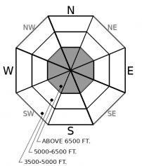
Yesterday's storm brought an uptick in avalanche activity. The snowpack is now adjusting, but human triggered avalanches are possible. These could break in the new and wind-drifted snow or on deeper weak layers. Travel cautiously in alpine terrain where fresh slabs are more widespread and persistent slabs have been more active.

2. Moderate
?
Above 6500 ft.
1. Low
?
5000-6500 ft.
1. Low
?
3500-5000 ft.
- 1. Low
- 2. Moderate
- 3. Considerable
- 4. High
- 5. Extreme
-
Type ?
-
Aspect/Elevation ?

-
Likelihood ?CertainVery LikelyLikelyPossible
 Unlikely
 -
Size ?HistoricVery LargeLargeSmall

Yesterday's storm left 4" to 6" of new snow in the Whitefish Range, accompanied by moderate to strong southwest winds. Shallow storm instabilities are most likely to be found on steep, wind affected terrain, where slabs are thicker or denser. Test small, steep slopes and look for shooting cracks before committing to larger terrain. Be extra cautious of thicker drifts behind leeward terrain features.
-
Type ?
-
Aspect/Elevation ?

-
Likelihood ?CertainVery LikelyLikelyPossible
 Unlikely
 -
Size ?HistoricVery LargeLargeSmall

Several large avalanches broke 3 to 4 feet deep into old snow layers over the weekend in adjacent mountain ranges: one resulted in a burial in the Swan Range and one was remotely triggered in Glacier Park. These persistent slabs give irregular feedback and are challenging to assess, but can produce surprisingly wide avalanches that break above you. Although this problem is isolated and difficult to trigger, you can reduce your risk by choosing terrain with a deep, uniform snowpack and avoid convex, rocky terrain. Collapses or whumpfs are clear signs to avoid steep terrain.
Storm totals from Sunday through Monday are 4" to 6" in the Whitefish Range, and 12" to 16" in the Flathead and Swan Ranges. The avalanche danger is more accute at higher elevations and in areas that picked up more snow. Observers yesterday reported tender soft slabs breaking a foot deep above Swan Lake and near Marion Lake. These instabilities were failing on weak layers within the storm snow, which generally heal quickly after the storm ends. The most problematic areas today will be upper elevations, where winds have stiffened slabs and you could encounter drifts up to several feet thick which will be slowest to heal.
Persistent slabs are another beast. They are like the creepy black van that has been lurking in your neighborhood for the past month giving you that uneasy feeling. Evidence of instabilities are rare, but they have been painting a subtle pattern of the most concerning terrain. 1) Parts of our forecast area with thinner, weaker snowpacks, such as the remotely triggered 4-foot slab near Snow Slip, or the collapses on Ousel Peak this weekend. Or 2) specific parts of the terrain that are shallow and variable, such as the persistent slab burial on Saturday that broke in rocky terrain, or the collapse yesterday on a windward terrain feature. Some of this terrain may sound inviting, as does a candy bar held out the window of your neighborhood van. But know that you assume a greater risk by going there. And right now there are plenty of safer options for good powder riding.
EDUCATION: We are offering the following upcoming classes: An Avalanche Awareness talk on Thursday, January 10 at The Stonefly Lounge at 7:00 p.m., a Motorized Level 1- Avalanche Fundamentals course on January 11-13, and a Ladies Introduction to Avalanches January 17 and 19
We'll see a brief lull in the weather today with partly cloudy skies and lighter winds. The next round of precipitation has moved onto the Pacific Coast this morning and will spread light snowfall into the region by tomorrow.
This forecast applies only to backcountry areas outside established ski area boundaries. The forecast describes general avalanche conditions and local variations always occur. This forecast expires at midnight on the posted day unless otherwise noted. The information in this forecast is provided by the USDA Forest Service who is solely responsible for its content.


