| Friday | Friday Night | Saturday | |
|---|---|---|---|
| Cloud Cover: | Overcast | Mostly Cloudy | Partly Cloudy |
| Temperatures: | 27 to 37 deg. F. | 15 to 25 deg. F. | 30 to 40 deg. F. |
| Wind Direction: | Southwest | Southwest | Southeast |
| Wind Speed: | 10 to 20 mph, gusting to 45 mph | 5 to 15 mph, gusting to 30 mph | 5 to 15 mph |
| Snowfall: | 3 to 6 in. | 0 to 1 in. | 0 in. |
| Snow Line: | 4000ft. | 4000ft. | 3500ft. |
Whitefish Range
Swan Range
How to read the forecast
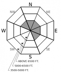
Today's go-to terrain is sheltered, mid-elevation slopes. That's terrain where you're least likely to encounter today's primary avalanche problem: freshly-formed wind slabs on leeward and cross-loaded slopes at upper elevations. And where you're least likely to stumble onto one of the few spots where you can still trigger a large, Persistent Slab avalanche. Step back to lower-angled slopes if you see or feel cracks shooting away from you or whumpfing collapses; these are clear signs of today's avalanche concerns.

2. Moderate
?
Above 6500 ft.
1. Low
?
5000-6500 ft.
1. Low
?
3500-5000 ft.
- 1. Low
- 2. Moderate
- 3. Considerable
- 4. High
- 5. Extreme
-
Type ?
-
Aspect/Elevation ?

-
Likelihood ?CertainVery LikelyLikelyPossible
 Unlikely
 -
Size ?HistoricVery LargeLargeSmall

Look for fresh slabs of drifted snow on leeward and cross-loaded slopes today. Fresh cornices are a sign the slope below has been recently loaded. The slabs will generally be soft, so pay attention to snow texture as you ride. Avoid steep gully walls and start zones with dense snow that shoots long, straight cracks away from you.
-
Type ?
-
Aspect/Elevation ?

-
Likelihood ?CertainVery LikelyLikelyPossible
 Unlikely
 -
Size ?HistoricVery LargeLargeSmall

The danger of triggering large slides that break several feet deep has grown isolated to terrain with the weakest snow and most trigger points. Give convex slopes with shallow snow cover, multiple trigger points, and recent accumulations of drifted snow a wide berth.
Thursday, gusty winds at upper elevations drifted snow near ridges and downwind of saddles. The drifted snow poses a danger where it collected into slabs eight inches or more thick. These slabs will remain sensitive to the weight of a person or snowmachine today, especially on slopes where loading contines. You’ll mostly find this danger near the summits of peaks and below exposed ridges along the crests of the Whitefish and Swan ranges. The most straightforward way to mitigate this danger is to simply avoid steep slopes where you find these conditions.
The danger of triggering large avalanches that break on old, weak snow has diminished to the point of being unlikely. We’ve received few reports of whumpfing collapses or avalanches from the Whitefish or Swan ranges in the past week or so. The terrain where it remains a danger is growing more isolated. Large, open slopes with numerous trigger points are the terrain where you can still get in trouble. There’s great riding on slopes that don’t fit this description.
The Whitefish Range – particularly the northern half - has seen more snowfall the past few days. A few more inches of snow are forecast for today. This fresh snow may be upside-down (denser at the surface). If you find more than about 8 inches of fresh snow that’s cracking around you or failing as small slides on steep test slopes, avoid slopes steeper than about 35 degrees.
This forecast applies only to backcountry areas outside established ski area boundaries. The forecast describes general avalanche conditions and local variations always occur. This forecast expires at midnight on the posted day unless otherwise noted. The information in this forecast is provided by the USDA Forest Service who is solely responsible for its content.


