| Friday | Friday Night | Saturday | |
|---|---|---|---|
| Cloud Cover: | Overcast | Mostly Cloudy | Partly Cloudy |
| Temperatures: | 27 to 37 deg. F. | 15 to 25 deg. F. | 30 to 40 deg. F. |
| Wind Direction: | Southwest | Southwest | Southeast |
| Wind Speed: | 10 to 20 mph, gusting to 45 | 5 to 15 mph, gusting to 30 | 5 to 15 mph |
| Snowfall: | 3 to 6 in. | 0 to 1 in. | 0 in. |
| Snow Line: | 4000 ft | 4000 ft | 3500 ft |
Flathead Range and Glacier National Park
How to read the forecast
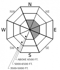
Today's go-to terrain is sheltered, mid-elevation slopes. It's the terrain where you're least likely to encounter today's avalanche problems: freshly-formed wind slabs at upper elevations and large, Persistent Slab avalanches that break in old snow at mid- and upper-elevations. Gusty winds and more snow are forecast for today, which should continue to improve riding conditions in the go-to terrain and maintain the lingering danger in the not-today terrain.

2. Moderate
?
Above 6500 ft.
2. Moderate
?
5000-6500 ft.
1. Low
?
3500-5000 ft.
- 1. Low
- 2. Moderate
- 3. Considerable
- 4. High
- 5. Extreme
-
Type ?
-
Aspect/Elevation ?

-
Likelihood ?CertainVery LikelyLikelyPossible
 Unlikely
 -
Size ?HistoricVery LargeLargeSmall

Look for fresh slabs of drifted snow on leeward and cross-loaded slopes today. These may be quite dense, with your machine or boards barely cutting into the snow. Slabs like these tend to break above you, so avoid undercutting steep slopes, like gully walls.
-
Type ?
-
Aspect/Elevation ?

-
Likelihood ?CertainVery LikelyLikelyPossible
 Unlikely
 -
Size ?HistoricVery LargeLargeSmall

It’s still possible to trigger large slides that break several feet deep on old weak layers. The likelihood of triggering these slides is highest on convex slopes with shallow snow cover, multiple trigger points, and recent accumulations of drifted snow. Give this terrain a wide berth.
Recent natural avalanche activity is clear evidence that there’s a lingering danger of triggering a large slide on old, weak snow. Most of the avalanche reports in the past week are concentrated in the southern Flathead Range, John F. Stevens Canyon, or the Marias Pass area. Many of these slides were large, and a few were dramatically large. The most recent occurred Thursday, on a southeast-facing slope that was likely cross-loaded by strong winds. It appeared to fail on weak facets near the ground, a layer that’s been reported consistently in the area over the past month.
The activity might be widespread through the Flathead Range and in the Lake McDonald area, but just not observed or reported. The upshot, though, is the same across the zone: avoid the slopes where your chances of triggering one of these beasts are greatest. Stick to sheltered terrain where the lack of wind scouring and drifting leaves a thicker, more consistent snow cover and fewer potential trigger points. Good candidates are shaded, mid-elevation slopes.
Thursday, observers reported strong southwesterly winds that drifted snow and formed some small, hard wind slabs in the southern part of the zone. I’m guessing similar conditions developed in the northern Flathead Range and around Lake McDonald as well. Wind speeds mostly dropped Thursday afternoon, and are forecast to keep trending down today, which should minimize wind slab growth.
Some freshly-formed wind slabs will be sensitive to the weight of a person today. Look for these near ridgelines on northeasterly and easterly slopes, and on the lee sides of gullies on more southerly slopes. If they’re hard – little to no ski or board penetration – they tend to break above you, so slope cuts aren’t an effective or safe tactic. Steer around them instead. Be aware that the debris from small triggered wind slabs may in turn trigger larger, more dangerous Persistent slab avalanches.
The northern part of the zone has seen more snowfall the past few days - 1.6 inches of snow water equivalent at the Flattop SNOTEL. This fresh snow may be upside-down (denser at the surface). If you find more than about 8 inches of fresh snow that’s cracking around you or failing as small slides on steep test slopes, avoid slopes steeper than about 35 degrees.
More mild temperatures, moderate winds, and a few more inches of snow today.
This forecast applies only to backcountry areas outside established ski area boundaries. The forecast describes general avalanche conditions and local variations always occur. This forecast expires at midnight on the posted day unless otherwise noted. The information in this forecast is provided by the USDA Forest Service who is solely responsible for its content.


