| Thursday | Thursday Night | Friday | |
|---|---|---|---|
| Cloud Cover: | Mostly cloudy | Mostly Cloudy | Mostly Cloudy |
| Temperatures: | 26 to 36 deg. F. | 20 to 30 deg. F. | 27 to 37 deg. F. |
| Wind Direction: | Southwest | Southwest | Southwest |
| Wind Speed: | 15 to 25 mph, gusting to 50 | 18 to 28 mph, gusting to 55 | 13 to 23 mph, gusting to 50 |
| Snowfall: | 1 to 3 in. | 1 to 3 in. | 3 to 5 in. |
| Snow Line: | 4500 ft | 5000 ft | 3500 ft |
Whitefish Range
Swan Range
Flathead Range and Glacier National Park
How to read the forecast
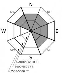
Blowin’ and snowin’… Wind and new precipitation today will again cause drifting onto leeward aspects. You may be able to trigger fresh winds slabs as drifted snow accumulates below ridgelines and on crossloaded features. We are still concerned that a triggered wind slab avalanche could step down into buried weak layers and cause a larger, more destructive slide. Carefully evaluate terrain with newly drifted snow at middle and upper elevations, especially on slopes harboring persistent weak layers.

2. Moderate
?
Above 6500 ft.
2. Moderate
?
5000-6500 ft.
1. Low
?
3500-5000 ft.
- 1. Low
- 2. Moderate
- 3. Considerable
- 4. High
- 5. Extreme
-
Type ?
-
Aspect/Elevation ?

-
Likelihood ?CertainVery LikelyLikelyPossible
 Unlikely
 -
Size ?HistoricVery LargeLargeSmall

A new generation of dense drifts will form today on leeward and crossloaded slopes as southwest winds redistribute thick new snow. Look for blowing snow and growing cornices when making your terrain choices. Be cautious as you transition into wind-affected terrain. Take extra care around features that stress the snowpack: convexities and unsupported slopes. Shooting cracks and collapsing are direct signs of instability.
-
Type ?
-
Aspect/Elevation ?

-
Likelihood ?CertainVery LikelyLikelyPossible
 Unlikely
 -
Size ?HistoricVery LargeLargeSmall

While the snowpack has been gaining strength, buried weak layers remain a concern. It’s hard to know exactly where and when persistent slabs will fail. Many of the recent persistent slab avalanche were triggered by smaller wind slabs overrunning weak layers. Weak layers can also fail under the weight of a single rider on the right slope. Consider avoiding steep, convex slopes and rocky areas with variable coverage. Better riding conditions will likely be found on smooth, sheltered slopes.
Winds gradually increased yesterday and continued blowing overnight. Most reports of drifting Wednesday came from the eastern half of the forecast area. Our friends at the BNSF railroad observed continuous wind loading and cornice development, but only small instabilities. In Canyon Creek winds were much lighter, and a layer of rime on the snow surface was preventing wind transport. If wind speeds and new snowfall reach forecasted amounts today, new drifts of 8” or deeper may form. The thicker the new drifts and the faster they build, the easier they will be to trigger. Typical trigger points for wind slabs include steep, leeward slopes just below cornices, and the sides of gullies that can become crossloaded. Convex slopes and rocky terrain should also give you second thoughts.
Large slides breaking on buried persistent weak layers remain a concern. On Monday, we recorded very large avalanches in the Essex area that failed on persistent weak layers during the last storm. Snowpack tests in Glacier on Tuesday showed that buried facets are still capable failure. The most recent round of persistent slab avalanches seem to have been triggered by smaller wind and storm slabs overrunning the buried weak layers. But don't rule out the possibility that a sigle rider hitting a hidden sweet spot could trigger these layers as well. Avoid triggering wind slabs and you are one step closer to avoiding a large and destructive persistent slab. Choosing sheltered, planar slopes with uniform steepness and snow cover is another good way to avoid the problem.
A warm weak disturbance will bring mixed precipitation and gusty winds today today before tapering late this evening. There will be a short-lived break in the weather before a similar system follows on Friday.
This forecast applies only to backcountry areas outside established ski area boundaries. The forecast describes general avalanche conditions and local variations always occur. This forecast expires at midnight on the posted day unless otherwise noted. The information in this forecast is provided by the USDA Forest Service who is solely responsible for its content.


