| Tuesday | Tuesday Night | Wednesday | |
|---|---|---|---|
| Cloud Cover: | Mostly cloudy | Partly Cloudy | Partly Cloudy |
| Temperatures: | 15 to 20 deg. F. | 6 to 11 deg. F. | 18 to 23 deg. F. |
| Wind Direction: | Southwest | Southwest | Southwest |
| Wind Speed: | 5 to 15 mph, gusting to 25 | 5 to 15 mph, gusting to 25 | 10 to 15 mph, gusting to 30 |
| Snowfall: | 0 in. | 0 in. | 0 in. |
| Snow Line: | 500 ft | 1000 ft | 1000 ft |
Whitefish Range
Swan Range
Flathead Range and Glacier National Park
How to read the forecast
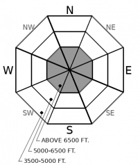
Shifting winds have formed several generations of wind slabs on a variety of aspects. Wind exposed slopes harbor instabilities in areas of drifted snow. Recent large destructive avalanche activity on buried weak layers confirms that persistent slabs remain a concern. Evaluate slopes affected by the wind and be suspicious of steep rocky terrain containing a variable snow depth.

2. Moderate
?
Above 6500 ft.
2. Moderate
?
5000-6500 ft.
1. Low
?
3500-5000 ft.
- 1. Low
- 2. Moderate
- 3. Considerable
- 4. High
- 5. Extreme
-
Type ?
-
Aspect/Elevation ?

-
Likelihood ?CertainVery LikelyLikelyPossible
 Unlikely
 -
Size ?HistoricVery LargeLargeSmall

Following a 24 hour period of winds out of the north and east, winds have returned to the prevailing southwest flow. Our recent storm provided plenty of low-density snow available for transport. Changing wind directions has resulted in several generations of wind slabs on a variety of aspects. Slabs will be thicker and more widespread below ridgelines and on cross-loaded features such as gullies. Fresh slabs are forming on low-density snow which may inhibit bonding. Look for lenses or pillows of snow with cracking a sign of instability.
-
Type ?
-
Aspect/Elevation ?

-
Likelihood ?CertainVery LikelyLikelyPossible
 Unlikely
 -
Size ?HistoricVery LargeLargeSmall

Our recent storm proves that buried weak layers in the bottom and middle of our snowpack remain a concern. Large destructive avalanches failed on these layers during this recent loading event. Many of these avalanches were in steep rocky terrain harboring areas of variable snow depth. Persistent slabs are a difficult problem to manage and often surprise us because they can be triggered remotely. Choosing terrain wisely is the best way to manage this problem. Avoiding steep rocky slopes, and areas containing a thin snowpack and convexities is your best bet.
Monday's bluebird conditions provided a great opportunity to observe avalanche activity associated with our recent storm. Observations were limited to areas around Essex in the Flathead Range and we do not have information from other locations. Highlights include (Example 1, Example 2, Example 3):
-Mid and upper elevations saw a widespread, storm slab cycle during the middle to latter part of the storm. These avalanches were breaking 5-10" on mid storm layers on all aspects with associated debris D1 to D1.5 in size.
-Upper elevation slopes produced wind slab avalanches up to 2' or 3' thick, that failed mid-storm, likely during the peak of wind loading on Saturday afternoon/night. These were mostly in cross-loaded gullies, D1.5 to D2 in size.
-Persistent slab avalanches (10?) that broke on older layers during the storm, D2 to D3 in size, 3 to 6 feet deep. One we estimate was a half-mile wide. More than half of these were step-downs, triggered by storm/wind slabs. These failed on a variety of aspects at mid and upper elevations, generally in rocky areas with variable snow coverage or on steep, cross-loaded convexities.
Today's surface instability is limited to recent wind drifted snow. Saturday/night, during the brunt of the storm, moderate to strong southwest winds drifted new snow onto easterly aspects. These slabs will be thickest and oldest of the lot. Sunday/night north and east winds drifted snow onto westerly aspects forming thin slabs. Monday morning the winds shifted back to the southwest forming fresh slabs on typical leeward aspects. Rather confusing, but the bottom line is to evaluate all recently loaded slopes before committing. Human triggered avalanches will be possible on all aspects affected by the wind.
A return to mostly cloudy conditions with cool but slightly warmer temperatures, light to moderate southwest winds and a few flurries. Continued warming and dry conditions on tap for tomorrow with continued light to moderate southwest winds.
This forecast applies only to backcountry areas outside established ski area boundaries. The forecast describes general avalanche conditions and local variations always occur. This forecast expires at midnight on the posted day unless otherwise noted. The information in this forecast is provided by the USDA Forest Service who is solely responsible for its content.


