| Friday | Friday Night | Saturday | |
|---|---|---|---|
| Cloud Cover: | Mostly Cloudy | Mostly Cloudy | Overcast |
| Temperatures: | 15 to 20 deg. F. | 10 to 15 deg. F. | 25 to 30 deg. F. |
| Wind Direction: | West-southwest | Southwest | Southwest |
| Wind Speed: | 10, gusting to 15 to 20 | 15 to 20 mph, gusting to 25 mph | 15 to 20 mph, gusting to 30 mph |
| Snowfall: | 0 in. | 0 in. | 0-1 in. |
| Snow Line: | 0 ft | 0 ft | 3000 ft |
Whitefish Range
Swan Range
Flathead Range and Glacier National Park
How to read the forecast
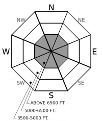
It remains possible to trigger avalanches that break one to two feet deep. This lingering danger is primarily a concern on high-elevation slopes steeper than about 35 degrees where dense slabs of drifted snow overly old weak layers. It is an isolated danger at mid elevations. If an approaching storm brings the strong winds and heavy snow that are forecast, the avalanche danger will rise this weekend.

2. Moderate
?
Above 6500 ft.
1. Low
?
5000-6500 ft.
1. Low
?
3500-5000 ft.
- 1. Low
- 2. Moderate
- 3. Considerable
- 4. High
- 5. Extreme
-
Type ?
-
Aspect/Elevation ?

-
Likelihood ?CertainVery LikelyLikelyPossible
 Unlikely
 -
Size ?HistoricVery LargeLargeSmall

To reduce your chances of triggering an avalanche that breaks on buried persistent weak layers, avoid steep terrain that harbors the combination of weak snow and stiff slabs - leeward and cross-loaded slopes near ridges. On other terrain, avoid riding near likely trigger points. Pick lines that keep you from crossing under old slabs of drifted snow near ridges, or dropping over convexities where a slope steepens abruptly. Slopes with the lower consequences are those with runouts free from rocks, trees, and gullies.
We’ve dropped the danger rating at mid-elevations to Low/ Level 1. You could treat that like a teenager hearing Mom and Dad left the car keys hanging by the door when they left town. As I remember it, that attitude led to trouble. Or you could consider Low Danger at mid elevations an indication that you can have great riding by avoiding the isolated slopes where Persistent Slabs remain a danger. It's like staying away from the one high school buddy that seemed to take it too far.
The mid-elevation slopes where you can still trigger a dangerous avalanche are generally steeper than about 35 degrees and have variable snow cover because they were scoured or cross-loaded during December’s storms. We haven't had reports of triggered slides on slopes like these in the past week, though snowpack tests have regularly produced propagating failures. These results are consistent across the forecast region - Elk Mountain, John F. Stevens Canyon, Noisy Basin, and the southern Whitefish Range. Safer riding options are sheltered slopes with a deeper, more uniform snow cover, no convex rollevers mid-slope, and runouts clear of trees, rocks and gullies. Whumpfing collapses and shooting cracks are clear signs of trouble ahead, so retreat to lower-angled, less consequential terrain.
At high elevations, the slabs leftover by December’s storms are more common, thicker, and wider. Snow depths are more variable from alternating rounds of wind loading and scouring. That makes the danger more widespread, so sticking to sheltered slopes less than 35 degrees is the easiest way to handle the problem. Avoid undercutting steep slopes below ridgelines, where it’s easier to trigger thick slabs on the slopes above.
The surface snow on most aspects and elevations is soft and makes for great, fast riding. It offers plenty of alternatives to the terrain harboring the Persistent Slab avalanche problem. But it may also get blown around easily when wind speeds increase this evening. If the winds arrive earlier than forecast, you may see small, shallow wind slabs develop. Best to avoid slopes where you see that happen.
A storm approaching this weekend has the potential to bring heavy snow to the forecast region – six to 12 inches accompanied by strong southwesterly winds. If the storm develops as forecast, the avalanche danger will rise as slabs of new and drifted snow bury the weak, soft snow currently at the surface.
A short-lived ridge will bring broken skies, light winds, and continued cold temperatures to the forecast region today. Wind speeds pick up tonight in advance of an approaching storm. While we may see light snow starting early Saturday morning, the heaviest snowfall is forecast for later in the day.
This forecast applies only to backcountry areas outside established ski area boundaries. The forecast describes general avalanche conditions and local variations always occur. This forecast expires at midnight on the posted day unless otherwise noted. The information in this forecast is provided by the USDA Forest Service who is solely responsible for its content.


