| Saturday | Saturday Night | Sunday | |
|---|---|---|---|
| Cloud Cover: | Partly cloudy | Mostly cloudy | Overcast |
| Temperatures: | 18 to 23 deg. F. | 11 to 16 deg. F. | 22 to 27 deg. F. |
| Wind Direction: | Southwest | South | Southwest |
| Wind Speed: | 5 to 15, gusting to 25 mph | 5 to 15, gusting to 25 mph | 5 to 15, gusting to 30 |
| Snowfall: | 0 in. | 0 in. | 1 to 3" in. |
| Snow Line: | 0 ft | 500 ft | 2000 ft |
Flathead Range and Glacier National Park
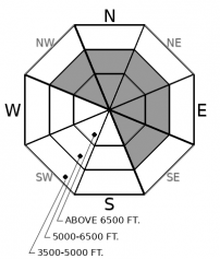
How to read the forecast
The likelilhood of triggering a large avalanche is decreasing, but the consequences remain serious. Steep, windloaded and crossloaded terrain is most suspect. Continue to evaluate the snow and terrain carefully.

2. Moderate
?
Above 6500 ft.
2. Moderate
?
5000-6500 ft.
1. Low
?
3500-5000 ft.
- 1. Low
- 2. Moderate
- 3. Considerable
- 4. High
- 5. Extreme
-
Type ?
-
Aspect/Elevation ?

-
Likelihood ?CertainVery LikelyLikelyPossible
 Unlikely
 -
Size ?HistoricVery LargeLargeSmall

Strong winds on Thursday night paired with 6"+ of fresh snow left wind slabs scattered across leeward terrain features at mid and upper elevations. Thicker drifts of snow could be sensitive to human triggers. Steer clear of pillowy looking drifts and denser deposits below ridgelines, in gullies, or behind steep rollovers. Cracking under foot or machine is a telltale sign of instability.
-
Type ?
-
Aspect/Elevation ?

-
Likelihood ?CertainVery LikelyLikelyPossible
 Unlikely
 -
Size ?HistoricVery LargeLargeSmall

December's storms have loaded persistent weak layers in the middle and bottom of the snowpack. Several hard slabs up to 5 feet thick failed during Tuesday's storm in the Flathead Range. These instabilities are becoming more difficult to find and trigger, but the consequences of triggering one demand careful terrain and snowpack assessments. Persistent slabs have potential to break above you or propagate surprisingly wide distances. Leave a wide margin for uncertainty near steep terrain. Concave, gladed terrain sheltered from the wind is safer than convex, windloaded slopes.
Most mountain locations have only picked up a couple inches of new snow in the past four days, and stability is generally improving. We have not observed any obvious signs of instability or avalanche activity since Tuesday's storm, which produced a number of slides up to D2.5 in size. In most locations, buried weak layers are catching their breath and the odds of triggering a persistent slab are decreasing as instabilities become increasingly stubborn and isolated. Flattop SNOTEL in Glacier Park has been the exception, squeezing out an additional 1.2" of SWE in the past two days. This equates to around a foot of snow, which was accompanied by winds gusting into the 50's on Thursday night. Continued loading in the Lake McDonald area, or other locations with similar snowfall amounts, equates to a greater likelihood of encountering a recent wind slab or larger persistent slab. I'll leave yesterday's discussion about persistent slabs up for one more day, to highlight the challenging nature of this problem.
On Thursday, our field teams in the Flathead came across several large persistent slab avalanches that ran during Tuesday's storm. A few comments on our social media page sum it up well: "Dayum!!" and "Daaaaang girrrrl". These aren't the kinds of avalanches that break predictably below you. In fact, failures can wrap around terrain features or up into slopes above you. They don't give obvious warning signs. Some may grumble with the occasional whumpf or shooting crack, but many lurk quietly. Stability tests are helpful, but not a silver bullet. Tracks on the slope aren't good feedback. The good news is these problems are spotty in distribution, and they are tough to trigger. But it is healthy to bring a cautious mindset into the backcountry today because the consequences of getting tangled in one of these beefy slabs will be quite unhealthy. The most dangerous slopes right now are windloaded alpine slopes; those where basal weak layers have been stressed the hardest and the snowpack has more variability. Surface hoar layers and sun crusts buried mid-pack are also a concern: be wary of protected slopes with good views of the sky and sunny aspects with substantial crossloading. If you have carefully assessed the snowpack and are moving into steep terrain, hedge your bets by traveling one at a time. Ease into smaller terrain and opt for slopes with broad, clean runouts. When in doubt, choose terrain less than about 33 degrees. That is your silver bullet.
We are offering an Avalanche Awareness talk Thursday, December 27 at Stumptown Snowboards at 7:00 p.m.! We are offering a Motorized Level 1- Avalanche Fundamentals course January 11-13!
A few lingering flurries, lighter winds, and a shot of sunshine characterize today's lull in the weather. Another weak disturbance arrives on Sunday.
This forecast applies only to backcountry areas outside established ski area boundaries. The forecast describes general avalanche conditions and local variations always occur. This forecast expires at midnight on the posted day unless otherwise noted. The information in this forecast is provided by the USDA Forest Service who is solely responsible for its content.


