| Friday | Friday Night | Saturday | |
|---|---|---|---|
| Cloud Cover: | Overcast | Mostly cloudy | Mostly cloudy |
| Temperatures: | 23 to 28 deg. F. | 13 to 18 deg. F. | 18 to 23 deg. F. |
| Wind Direction: | Southwest | Southwest | Southwest |
| Wind Speed: | 15 to 25, gusting 50 mph | 10 to 20, gusting to 30 mph | 7 to 17, gusting to 30 mph |
| Snowfall: | 1-4" in. | 0 to 1" in. | 0 in. |
| Snow Line: | 1500 | 0 | 0 |
Flathead Range and Glacier National Park
How to read the forecast
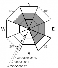
Strong winds overnight are drifting 6"+ of new snow into fresh slabs behind leeward terrain features. Lurking under a disguise of fresh snow and surface instabilities, deeper weak layers have produced surprisingly large and dangerous avalanches this week. The hazard for both of these issues is most widespread on leeward and crossloaded slopes near summits and ridgelines. Slopes sheltered from the wind and sky offer good riding today and are less likely to harbor buried weak layers.

3. Considerable
?
Above 6500 ft.
2. Moderate
?
5000-6500 ft.
1. Low
?
3500-5000 ft.
- 1. Low
- 2. Moderate
- 3. Considerable
- 4. High
- 5. Extreme
-
Type ?
-
Aspect/Elevation ?

-
Likelihood ?CertainVery LikelyLikelyPossible
 Unlikely
 -
Size ?HistoricVery LargeLargeSmall

6" of new snow accompanied by gusty winds will easily drift into pockets of unstable snow behind leeward features. Fresh wind slabs will continue to grow in size through the day and could be up to 18" thick below ridgelines. Watch for blowing snow, cracking underfoot, or thicker feeling snow drifts to clue you into trouble. Winds have been strong enough to form slabs further downslope than you might expect: below rollovers and in gullies at mid and upper elevations. Natural or human triggered wind slabs could step down to initiate larger persistent slab avalanches.
-
Type ?
-
Aspect/Elevation ?

-
Likelihood ?CertainVery LikelyLikelyPossible
 Unlikely
 -
Size ?HistoricVery LargeLargeSmall

December's storms have loaded persistent weak layers in the middle and bottom of the snowpack. Several persistent slabs up to 5 feet thick failed during Tuesday's storm, resulting in large and dangerous avalanches. These variably distributed and stubborn slabs complicate safe travel today. Persistent slabs can break above you or connect to adjacent slopes. Pay attention to terrain around you, and leave a wide margin for surprises when assessing and traveling near slopes steeper than 30 degrees. Concave, gladed terrain sheltered from the wind is safer than convex, windloaded slopes with variable snow depths.
Most mountain locations picked up a couple of inches of new snow last night (.2" SWE), but closer to the Continental Divide, some stations are reporting larger amounts. Flattop SNOTEL in Central Glacier Park won the overnight snow contest with over 6" (.8" of SWE). With gusty winds mixing into all elevations, fresh wind slabs are in the making. The danger is higher in areas that saw more snow, where wind slabs will be thicker and more widespread.
Yesterday, our field teams in the Flathead came across several large persistent slab avalanches that ran during Tuesday's storm. A few comments on our social media page sum it up well: "Dayum!!" and "Daaaaang girrrrl". These aren't the kinds of avalanches that break predictably below you. In fact, failures can wrap around terrain features or up into slopes above you. They don't give obvious warning signs. Some may grumble with the occasional whumpf or shooting crack, but many lurk quietly. Stability tests are helpful, but not a silver bullet. Tracks on the slope aren't good feedback. The good news is these problems are spotty in distribution, and they are tough to trigger. But it is healthy to bring a cautious mindset into the backcountry right now because the consequences of getting tangled in one of these beefy slabs will be quite unhealthy. The most dangerous slopes right now are windloaded alpine slopes; those where basal weak layers have been stressed the hardest and the snowpack has more variability. Surface hoar layers and sun crusts buried mid-pack are also a concern: be wary of protected slopes with good views of the sky and sunny aspects with substantial crossloading. If you have carefully assessed the snowpack and are moving into steep terrain, hedge your bets by traveling one at a time. Ease into smaller terrain and opt for slopes with broad, clean runouts. When in doubt, choose terrain less than about 33 degrees. That is your silver bullet.
We are offering an Avalanche Awareness talk Thursday, December 27 at Stumptown Snowboards at 7:00 p.m.! We are offering a Motorized Level 1- Avalanche Fundamentals course January 11-13!
Under a cooling trend, we'll see snow showers lingering into this evening. Winds have been gusting into the 30s in the valleys and near 50 mph at exposed ridgelines. This pattern should continue through the day and ease overnight. Saturday provides a break in the action before more active weather arrives next week.
This forecast applies only to backcountry areas outside established ski area boundaries. The forecast describes general avalanche conditions and local variations always occur. This forecast expires at midnight on the posted day unless otherwise noted. The information in this forecast is provided by the USDA Forest Service who is solely responsible for its content.


