| Thursday | Thursday Night | Friday | |
|---|---|---|---|
| Cloud Cover: | Broken | Overcast | Overcast |
| Temperatures: | deg. F. | deg. F. | deg. F. |
| Wind Direction: | 29-34 | 15-20 | 24-29 |
| Wind Speed: | S/SW10, gust to 20 and increasing. | SW15-20 gusting to 25 | SW/W15-20 gusting to 25 |
| Snowfall: | 0 in. | 3-6" in. | 1-3" in. |
| Snow Line: | 4000 | 3500 | 1500 |
Whitefish Range
Swan Range
Flathead Range and Glacier National Park
How to read the forecast
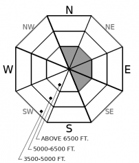
Today you can trigger dense slabs of drifted snow deposited by this week’s storm. These can break at the old snow surface, or on deeply buried weak layers. Triggered slides will be large enough to be dangerous. The hazard is most widespread on leeward and crossloaded slopes near summits and ridgelines. Slopes sheltered from the wind and sky offer good riding today and are less likely to harbor buried weak layers.

2. Moderate
?
Above 6500 ft.
2. Moderate
?
5000-6500 ft.
1. Low
?
3500-5000 ft.
- 1. Low
- 2. Moderate
- 3. Considerable
- 4. High
- 5. Extreme
-
Type ?
-
Aspect/Elevation ?

-
Likelihood ?CertainVery LikelyLikelyPossible
 Unlikely
 -
Size ?HistoricVery LargeLargeSmall

December’s storms have loaded weak layers near the base of the snow pack (Glacier National Park and Flathead Range) or closer to the surface (Whitefish and Swan Ranges). These layers complicate safe travel. You can trigger thick slabs from below, or from adjacent slopes. Because they break deep in the snowpack, they can be surprisingly large. Pay careful attention to terrain around you, and leave a wide margin for surprises when assessing and traveling near slopes steeper than 30 degrees.
-
Type ?
-
Aspect/Elevation ?

-
Likelihood ?CertainVery LikelyLikelyPossible
 Unlikely
 -
Size ?HistoricVery LargeLargeSmall

Strong, gusty winds during this week's storm drifted snow near and below exposed ridges and summits. Impressive cornices are a sign of this loading on the slopes below. These slabs remain sensitive to the weight of a person or snowmachine. Avoiding steep slopes like these is the most straightforward way to mitigate this hazard. Increasing wind speeds today could drift more snow and continue building slabs.
This week’s storm seems to have swept in and out of the room without sparking much talk from the snowpack. Despite impressive amounts of water (1-2” of SWE), we have received limited reports of natural or triggered slides. Test slopes and snowpack tests aren’t producing alarming results on the storm interface. Good news, except that there’s some grumbling from deeper in the snowpack.
December’s storms have loaded buried weak layers that are still sensitive to the weight of a person or snowmachine, and, if triggered, can involve dangerous amounts of debris. In the Whitefish and Swan Ranges, the potential failure planes include buried surface hoar and facets around crusts near the ground. The first seems localized to open slopes with unobstructed views of the sky. The second is most widespread on southerly slopes and easterly slopes where cross-loading has buried them with dense, hard slabs of drifted snow. This last structure was the culprit in a burial in the souther Whitefish Range last week, and likely for a remotely-triggered hard slab on Tuesday. Both occurred on mid-elevation, easterly slopes. In the Swan Range, a skier remotely triggered a dense slab on a southeasterly-facing slope below Mt. Aeneas.
In the Flathead Range and Glacier National Park, the most problematic layer is weak, faceted snow near the base of the snowpack. This layer is consistently producing propagation in snowpack tests, as well as some whumfing collapses. The slab above this layer is dense and thick.
To ride safely with these lurking dangers, leave a wide margin for surprises. Pay close attention to slope angles and aspects, so you can avoid riding on or under steep slopes likely to harbor deeply buried weak layers. Shooting cracks and whumpfing collapses are unambiguous signs of this danger. Minimize the consequences of surprises by riding one at a time and always keeping your partners in sight.
Our next Avalanche Awareness talk is Thursday, December 20th at Penco Power Products at 6:30 p.m.!
We are offering an Avalanche Awareness talk Thursday, December 27 at Stumptown Snowboards at 7:00 p.m.!
We are offering a Motorized Level 1- Avalanche Fundamentals course January 11-13!
Today will be a break between storms, with mild temperatures, broken skies and light winds through early afternoon. Wind speeds will tick up later this afternoon, and light snow is forecast for tonight.
This forecast applies only to backcountry areas outside established ski area boundaries. The forecast describes general avalanche conditions and local variations always occur. This forecast expires at midnight on the posted day unless otherwise noted. The information in this forecast is provided by the USDA Forest Service who is solely responsible for its content.


