| Wednesday | Wednesday Night | Thursday | |
|---|---|---|---|
| Cloud Cover: | Broken | Broken | Broken |
| Temperatures: | deg. F. | deg. F. | deg. F. |
| Wind Direction: | 25-31 | 20-25 | 30-35 |
| Wind Speed: | W 15-20G30 | SW 10-15 G25 | S 10-15 G25 |
| Snowfall: | 1-2" in. | 0-2" in. | none in. |
| Snow Line: | 3000 | 2500 | 4000 |
Swan Range
How to read the forecast
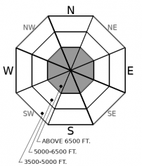
Dangerous conditions exist on or below steep slopes near ridgelines today. Dense snow and gusty winds have created slabs 1-3 feet thick that will be reactive to the weight of a person or snowmachine. Natural avalanches are also possible. Both triggered and natural slides could break into deeply buried weak layers. The likelihood of triggering slides – and their potential size – will be greatest at upper elevations.

3. Considerable
?
Above 6500 ft.
2. Moderate
?
5000-6500 ft.
1. Low
?
3500-5000 ft.
- 1. Low
- 2. Moderate
- 3. Considerable
- 4. High
- 5. Extreme
-
Type ?
-
Aspect/Elevation ?

-
Likelihood ?CertainVery LikelyLikelyPossible
 Unlikely
 -
Size ?HistoricVery LargeLargeSmall

On slopes steeper than about 30 degrees, you can trigger slabs that break in the new snow or at the interface with the old snow. These will be thickest and most reactive on wind-loaded and cross-loaded slopes. This hazard is most widespread at upper elevations, near or below leeward ridgelines and in cross-loaded gullies and bowls. Gusty wind today will continue to drift snow, keeping the likelihood of triggering slides elevated.
-
Type ?
-
Aspect/Elevation ?

-
Likelihood ?CertainVery LikelyLikelyPossible
 Unlikely
 -
Size ?HistoricVery LargeLargeSmall

Some triggered or natural slides could break on old weak layers. These slides can be triggered from adjacent slopes or from below, and triggered slides can break across terrain features. While this hazard is more isolated than that involving only new and drifted snow, any triggered slides will be wider and involve surprising amounts of debris. Avoid stopping or riding on or under slopes steeper than about 30 degrees.
Another warm, windy storm swept across the forecast region on Tuesday and Tuesday night. Storm water totals for the Swan Range are 0.6-1.0" of Snow Water Equivalent, which is about 4-8 inches of snow. The northern part of the range, including Lost Johnny, may have picked up more.
Gusty southwesterly winds accompanied the snowfall. These were most sustained at upper elevations, near summits and ridgelines. The winds drifted snow and cross-loaded southerly slopes Tuesday. This loading was most extensive on leeward (easterly and northeasterly) near ridgelines, though observers reported some cross-loading at mid elevations.
Gusty southwesterly winds accompanied the snowfall. These were most sustained at upper elevations near summits and ridgelines. The winds drifted snow and cross-loaded southerly slopes Tuesday. This loading was most extensive on leeward (easterly and northeasterly) slopes near ridgelines, though observers reported some cross-loading at mid elevations.
The combination of new and drifted snow has increased the avalanche danger on and below steep slopes. Freshly-formed slabs pose a danger in themselves. The most widespread danger will be Storm Slab avalanches at upper elevations. Slopes where drifted snow has thickened and stiffened the recent snow will be most dangerous.
Freshly-formed slabs have also increased the load on various old weak layers buried mid-pack or deeper. These include basal facets, surface hoar, and facets around crusts. Various combinations exist on all aspects, but they’re reactive on isolated slopes. So leave a wide margin for surprises.
Our next Avalanche Awareness talk is Thursday, December 20th at Penco Power Products at 6:30 p.m.!
We are offering an Avalanche Awareness talk Thursday, December 27 at Stumptown Snowboards at 7:00 p.m.!
We are offering a Motorized Level 1- Avalanche Fundamentals course January 11-13!
Gusty winds will continue to blow from the southwest and west today. Wind speeds should be highest at upper elevations, though they'll mix down to mid elevations at time. Snow showers today will bring a few inches more snow. Thursday, expect warmer temperatures and lighter winds.
This forecast applies only to backcountry areas outside established ski area boundaries. The forecast describes general avalanche conditions and local variations always occur. This forecast expires at midnight on the posted day unless otherwise noted. The information in this forecast is provided by the USDA Forest Service who is solely responsible for its content.


