| Monday | Monday Night | Tuesday | |
|---|---|---|---|
| Cloud Cover: | Mostly cloudy | Overcast | Overcast |
| Temperatures: | 30 to 35 deg. F. | 25 to 30 deg. F. | 30 to 35 deg. F. |
| Wind Direction: | Southwest | Southwest | South |
| Wind Speed: | 10 to 15mph, Gusting to 30mph | 15 to 20mph, Gusting to 40mph | 20 to 25mph, Gusting to 40mph |
| Snowfall: | 1 to 3 in. | 1 to 3 in. | 8 to 12 in. |
| Snow Line: | 5000 ft | 3500 ft | 4500 ft |
Whitefish Range
Swan Range
Flathead Range and Glacier National Park
How to read the forecast
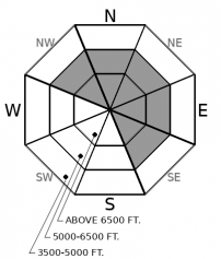
Recent mild and dry conditions have allowed our snowpack to gain strength. Yet, cracking, collapsing and triggered avalanches are still occurring in wind drifted areas. Test the snowpack beneath ridgelines and cross-loaded slopes.

2. Moderate
?
Above 6500 ft.
2. Moderate
?
5000-6500 ft.
1. Low
?
3500-5000 ft.
- 1. Low
- 2. Moderate
- 3. Considerable
- 4. High
- 5. Extreme
-
Type ?
-
Aspect/Elevation ?

-
Likelihood ?CertainVery LikelyLikelyPossible
 Unlikely
 -
Size ?HistoricVery LargeLargeSmall

Breezy conditions continue to drift snow increasing the thickness and distribution of slabs. Slabs are gaining strength but cracking in the surface snow is still being reported. Many slabs rest on weak snow which slows the strengthening process and is responsible for continued collapsing (whumphing). Yesterday, Clancy triggered a wind slab avalanche with a cornice fall in the Swan Range. Evaluate dense snow beneath ridgelines along with pillow features on steep slopes. Wind sheltered terrain offers safer and higher quality snow.
We are starting to sound like a broken record but today is another day of wind slab concerns. Breezy conditions are drifting our soft surface snow onto leeward and cross-loaded aspects. Wind slabs continue to thicken and are slow to heal due to the weak snow that they rest on. Locations of these slabs should not be a surprise due to the continued typical southwest flow.
Today is the calm before the storm. Light mixed precipitation enters our area before a much stronger system tonight. Expect dense snow at middle and upper elevations with a rain/snow mix at lower elevations. This will result in dangerous avalanche conditions developing. The new load will test our well advertised buried weak layers. Tomorrow, you will want to adjust your terrain choices to align with the changing conditions.
Our next Avalanche Awareness talk is Thursday, December 20th at Penco Power Products at 6:30 p.m.!
We are offering a Motorized Level 1- Avalanche Fundamentals course January 11-13
A weak storm system is currently moving into the Northern Rockies this morning. Light precipitation will fall as snow at middle and upper elevations with a rain/snow mix at lower elevations. A strong warm moist system enters our area tomorrow!
This forecast applies only to backcountry areas outside established ski area boundaries. The forecast describes general avalanche conditions and local variations always occur. This forecast expires at midnight on the posted day unless otherwise noted. The information in this forecast is provided by the USDA Forest Service who is solely responsible for its content.


