| Sunday | Sunday Night | Monday | |
|---|---|---|---|
| Cloud Cover: | Increasing Clouds | Mostly cloudy | Overcast |
| Temperatures: | 29 to 39 deg. F. | 25 to 35 deg. F. | 29 to 39 deg. F. |
| Wind Direction: | South | South | Southwest |
| Wind Speed: | 12 to 22mph, Gusting to 39mph | 15 to 25mph, Gusting to 40mph | Around 20mph, Gusting to 40mph |
| Snowfall: | 0 in. | 1 to 4 in. | 2 to 6 in. |
| Snow Line: | 5500 ft | 6000 ft | 5000 ft |
Whitefish Range
Swan Range
Flathead Range and Glacier National Park
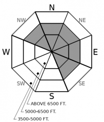
How to read the forecast
While the snowpack is slowly strengthening after this week’s storm, people continue to report cracking and collapsing in areas of drifted snow. Evaluate the snowpack carefully around leeward terrain, above terrain traps, and near rocky or open slopes steeper than about 30 degrees.

2. Moderate
?
Above 6500 ft.
2. Moderate
?
5000-6500 ft.
1. Low
?
3500-5000 ft.
- 1. Low
- 2. Moderate
- 3. Considerable
- 4. High
- 5. Extreme
-
Type ?
-
Aspect/Elevation ?

-
Likelihood ?CertainVery LikelyLikelyPossible
 Unlikely
 -
Size ?HistoricVery LargeLargeSmall

Several wind slabs failed naturally or were triggered on Thursday across the forecast area. Yesterday, observations from the southern Whitefish Range confirm what we saw earlier in the week in the Flathead Range. Collapses, cracking, and cornice failures point to heightened avalanche conditions in and near wind loaded terrain. Slabs can break up to several feet thick on buried weak layers that are slow to heal. Watch for cracking in denser snow and avoid round drifts or dunes below cornices and in gullies. Choose wind sheltered or lower angle terrain to avoid the problem.
The scales of stability have continued to teeter between strength and failure. Blowing snow at upper elevations, surface cracking, along with failure in snowpack tests were reported through Saturday. Observations like these show that drifting snow is still overloading weak layers in the snowpack. Unstable storm slabs are becoming less common as our weak and faceted snowpack gradually adjusts to storm snow from the past week. We expect wind stiffened snow, even on more sheltered slopes where the snowpack is shallower, to remain the most sensitive. Leeward rollovers and steep, open, downwind slopes harbor the highest risk. When faced with uncertainty give yourself a margin for error by choosing slopes of about 30 degrees or less. Temperatures will be warming again today with freezing level climbing into the middle elevations by tonight. Loose wet avalanches are not expected to be a significant hazard today, but any larger point releases late in the afternoon could trigger larger slab avalanches below. Thawing could continue to be a problem as warm moisture surges into the area later tonight.
Our next Avalanche Awareness talk is Thursday, December 20th at Penco Power Products at 6:30 p.m.!
Today is a transitional weather day. A wetter pattern is on the horizon. High pressure pushes eastward today before warm air and subtropical moisture produce a few inches of thick, wet snow overnight. Precipitation tonight and Monday will favor the Swan Range. Another, more significant surge of moisture follows early next week. The air associated with this next storm will be very warm and snow levels will be high.
This forecast applies only to backcountry areas outside established ski area boundaries. The forecast describes general avalanche conditions and local variations always occur. This forecast expires at midnight on the posted day unless otherwise noted. The information in this forecast is provided by the USDA Forest Service who is solely responsible for its content.


