| Saturday | Saturday Night | Sunday | |
|---|---|---|---|
| Cloud Cover: | Mostly cloudy | Partly cloudy | Partly cloudy |
| Temperatures: | 25 to 35 deg. F. | 15 to 25 deg. F. | 29 to 39 deg. F. |
| Wind Direction: | Southwest | South-Southwest | South-Southwest |
| Wind Speed: | 20 to 40mph, Gusting to 60mph | 15 to 25mph, Gusting to 40mph | 15 to 25mph, Gusting to 30mph |
| Snowfall: | 1 to 3 in. | 0 in. | 0 in. |
| Snow Line: | 3000 ft | 3000 ft | 5000 ft |
Whitefish Range
Swan Range
Flathead Range and Glacier National Park
How to read the forecast
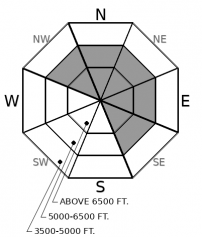
The snowpack is adjusting and the danger is trending down, but you can still trigger a large avalanche, especially in windloaded terrain at mid and upper elevations. Blustery Southwest winds continue to add weight to dense slabs near ridgelines and on crossloaded slopes. Use caution around leeward terrain, above terrain traps, and near steep, rocky, or open slopes.

2. Moderate
?
Above 6500 ft.
2. Moderate
?
5000-6500 ft.
1. Low
?
3500-5000 ft.
- 1. Low
- 2. Moderate
- 3. Considerable
- 4. High
- 5. Extreme
-
Type ?
-
Aspect/Elevation ?

-
Likelihood ?CertainVery LikelyLikelyPossible
 Unlikely
 -
Size ?HistoricVery LargeLargeSmall

The gusty southwest winds we saw yesterday will continue to drift and thicken slabs below ridgelines and in leeward terrain features. Observations from the Flathead Range yesterday reported collapses, cracking, and snowpack test failures in wind loaded terrain, and several thick, wind drifted slabs were triggered on Thursday in all 3 forecast areas. Use caution below leeward ridgelines and on cross-loaded slopes, especially where the surface snow feels thicker. Slabs can break up to several feet thick on buried weak layers that are slow to heal. Watch for cracking in denser snow and avoid thicker, pillowy drifts or dunes below cornices and in gullies. Choose wind sheltered or lower angle terrain to avoid the problem.
Stability continues to show signs of improvement after Tuesday night's storm and avalanche cycle, but it is possible to trigger a slide large enough to injure or kill you today. Blowing snow at upper elevations, cracking, collapses, and clean failures in snowpack tests were reported yesterday in wind loaded terrain of the Swan and Flathead ranges (Example 1, Example 2). Storm slab instabilities are becoming less common as our weak and faceted snowpack gradually adjusts to upwards of 2" of SWE, and the problem is becoming more specific to wind affected terrain. Slabs stiffened by wind remain the most sensitive. Although these are most common near ridgeline, strong winds this week have also formed denser slabs further down slope and in more sheltered terrain than you might expect. Wind-loaded terrain and steep or unsupported rollovers are typically the slowest to heal under these conditions. Hunt down the softest powder and you've likely found the best stability. When faced with uncertainty give yourself a bigger margin for error by choosing less steep or less consequential terrain.
Our next Avalanche Awareness talk is Thursday, December 20th at Penco Power Products at 6:30 p.m.!
Showery precipitation will continue through this morning with a few inches of new snow in the mountains. Gusty winds and warm temperatures will slowly trend downward into this evening.
This forecast applies only to backcountry areas outside established ski area boundaries. The forecast describes general avalanche conditions and local variations always occur. This forecast expires at midnight on the posted day unless otherwise noted. The information in this forecast is provided by the USDA Forest Service who is solely responsible for its content.


