| Thursday | Thursday Night | Friday | |
|---|---|---|---|
| Cloud Cover: | Mostly Cloudy | Decreasing clouds | Partly cloudy |
| Temperatures: | 28 to 33 deg. F. | 20 to 25 deg. F. | 31 to 36 deg. F. |
| Wind Direction: | Southwest | Southwest | South |
| Wind Speed: | 10-20 mph, gusting to 40 | 10-20 mph, gusting to 40 | 10-20 mph, gusting to 30 |
| Snowfall: | 1-3" in. | 0 in. | 0 in. |
| Snow Line: | 3000 ft | 2500 feet | 3500 ft |
Swan Range
How to read the forecast
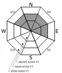
Winds continue to transport recent snow from Tuesday night's storm, and observers noted several natural avalanches breaking in windloaded terrain yesterday. Use caution below leeward ridges and in crossloaded gullies. Shooting cracks and blowing snow are signs of instability

2. Moderate
?
Above 6500 ft.
2. Moderate
?
5000-6500 ft.
1. Low
?
3500-5000 ft.
- 1. Low
- 2. Moderate
- 3. Considerable
- 4. High
- 5. Extreme
-
Type ?
-
Aspect/Elevation ?

-
Likelihood ?CertainVery LikelyLikelyPossible
 Unlikely
 -
Size ?HistoricVery LargeLargeSmall

Gusty Southwest winds continue to drift and thicken slabs below ridgelines and in leeward terrain features. Observers yesterday reported several natural slab avalanches that broke up to 2 feet thick in heavily windloaded terrain in the Swan Range. These avalanches are breaking on buried weak layers that may not heal quickly. Watch for cracking in denser snow and avoid thicker, lens-shaped drifts below cornices and in gullies. Choose wind sheltered or lower angle terrain to avoid the problem.
Tuesday night's storm dropped a quick hit on a fragile weak layer, resulting in widespread slab avalanche activity. The storm delivered bigger snow amounts to the northern half of our forecast area (the Stahl Peak and Flattop SNOTELS picked up 1.5" of SWE), creating dangerous avalanche conditions in the Whitefish Range and Northern parts of the Flathead and GNP. In the Whitefish Range, our forecasters reported dozens of natural slab avalanches breaking at the storm interface at mid and upper elevations, and easily triggered slides and shooting cracks. (Example A, Example B). Although natural activity is winding down, these slabs will remain tender to human triggers on slopes steeper than 35 degrees. Slabs are breaking about a foot deep and have potential to gouge into older snow layers once they get moving. The southern half of our forecast area, including the Swan Range and areas around Essex, saw smaller storm totals and fewer instabilities. Blase was in Noisy Basin yesterday and reported a few naturals localized to heavily wind drifted slopes. The avalanche danger is lower in these areas that saw lighter accumulations: slab instabilities are smaller and confined to wind loaded terrain features. Pay attention to new snow amounts in your travels and anticipate bigger, more widespread issues if you find more than 10" of snow over our recently buried facet layers.
The changing conditions make your observations even more valuable. If you get into the mountains, let us know what you see.
Our next Avalanche Awareness talk is Thursday, December 20th at Penco Power Products at 6:30 p.m.!
Another disturbance is moving onshore today and will bring a few more inches of snowfall, favoring the northern half of our advisory area. Blustery winds continue at upper elevations and temperatures will rise to near freezing.
This forecast applies only to backcountry areas outside established ski area boundaries. The forecast describes general avalanche conditions and local variations always occur. This forecast expires at midnight on the posted day unless otherwise noted. The information in this forecast is provided by the USDA Forest Service who is solely responsible for its content.


