| Tuesday | Tuesday Night | Wednesday | |
|---|---|---|---|
| Cloud Cover: | Overcast | Overcast | Mostly cloudy |
| Temperatures: | 26-30 deg. F. | 18-22 deg. F. | 23-27 deg. F. |
| Wind Direction: | Southwest -> West | West | West |
| Wind Speed: | 10-20, gusting to 30 | 15-25, gusting to 40 | 10-20, gusting to 30 |
| Snowfall: | 2-3 in. | 6-8 in. | 2-4 in. |
| Snow Line: | 2500 | 2000 | 2000 |
Whitefish Range
Swan Range
Flathead Range and Glacier National Park
How to read the forecast
AN AVALANCHE WATCH IS IN EFFECT until Wednesday at noon.
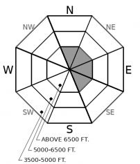
Ch-ch-changes. The avalanche danger is rising as new and drifted snow accumulates. Today you can trigger small avalanches on steep slopes, mostly near ridgelines. Step back and reconsider if you see shooting cracks or feel collapses near steep, open slopes at any elevation. With heavy snow and gusty winds forecast for tonight, dangerous conditions are likely to develop overnight.

2. Moderate
?
Above 6500 ft.
2. Moderate
?
5000-6500 ft.
1. Low
?
3500-5000 ft.
- 1. Low
- 2. Moderate
- 3. Considerable
- 4. High
- 5. Extreme
-
Type ?
-
Aspect/Elevation ?

-
Likelihood ?CertainVery LikelyLikelyPossible
 Unlikely
 -
Size ?HistoricVery LargeLargeSmall

Increasing wind speeds and a few inches of new snow over the past two days has left small, thin slabs scattered near ridgelines. With more snow and gusty winds forecast for today, these will become larger, more common, and more sensitive today. They can be dangerous where they've formed on slopes steeper than about 35 degrees and a foot or more thick. Look for drifts and dunes on the easterly sides of ridges, chutes, and prominent terrain features.
-
Type ?
-
Aspect/Elevation ?

-
Likelihood ?CertainVery LikelyLikelyPossible
 Unlikely
 -
Size ?HistoricVery LargeLargeSmall

As new and drifted snow accumulates, the danger of triggering small slabs on steep slopes will rise. These slabs can break on at the old snow/ new snow interface, or on a buffet of buried weak layers. These weak layers exist on both sunny and shady slopes. Look out for open slopes steeper than about 33 degrees where 8 inches or more of new and drifted snow has accumulated. The shallow snowpack means even a short ride in a small avalanche can rake you over stumps, rocks, and other things harder than your body.
Recently-formed wind slabs have been sensitive to a person's weight in isolated pockets near ridgelines (Example, Example). This danger will grow more widespread today as wind speeds tick up, veer west or west-northwest, and new snow is available for transport.
Cold, dry conditions have left the snowpack at mid and upper elevations weak and riddled with weak layers, including facets at the surface and near crusts, as well as surface hoar (Example). It won't take much of a slab for conditions to get dangerous. Snowfall the past few days is the start of that slab, and the continuing snowfall forecast for today and tonight may be enough to create widespread, stiff slabs on steep slopes at mid and upper elevations. The bottom line: don't misunderstimate the danger developing with this storm.
The changing conditions make your observations even more valuable. If you get into the mountains, let us know what you see.
Our next Avalanche Awareness talk is Thursday, December 20th at Penco Power Products at 6:30 p.m.!
Expect scattered snow and increasing winds today. A stronger storm is approaching from the coast; this system could bring heavy snow and gusty winds tonight.
This forecast applies only to backcountry areas outside established ski area boundaries. The forecast describes general avalanche conditions and local variations always occur. This forecast expires at midnight on the posted day unless otherwise noted. The information in this forecast is provided by the USDA Forest Service who is solely responsible for its content.


