| Sunday | Sunday Night | Monday | |
|---|---|---|---|
| Cloud Cover: | 50% | 55% | 65% |
| Temperatures: | 25-30 deg. F. | 15-20 deg. F. | 25-30 deg. F. |
| Wind Direction: | South/Southwest | South/Southwest | South/Southwest |
| Wind Speed: | 5-10 mph with gusts to 25 | 10-15 mph with gusts to 30 | 15-20 mph with gusts to 30 |
| Snowfall: | 0 in. | 0 in. | 0-2 in. |
| Snow Line: | 2500 | 2500 | 2500 |
Whitefish Range
Swan Range
Flathead Range and Glacier National Park
How to read the forecast
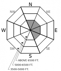
Recent winds have formed thin isolated slabs at upper elevations. Evaluate wind loaded terrain below ridgelines and in gulleys. Expect generally stable conditions on wind protected slopes. Sluffing is possible in very steep terrain. Early season obstacles can increase the consequences of an avalanche.

1. Low
?
Above 6500 ft.
1. Low
?
5000-6500 ft.
1. Low
?
3500-5000 ft.
- 1. Low
- 2. Moderate
- 3. Considerable
- 4. High
- 5. Extreme
-
Type ?
-
Aspect/Elevation ?

-
Likelihood ?CertainVery LikelyLikelyPossible
 Unlikely
 -
Size ?HistoricVery LargeLargeSmall

Several days of light southwest winds have formed thin soft slabs on leeward aspects. Slabs are resting on weak layers or crusts which may inhibit bonding. Getting caught in even a small slide can have bad consequences due to the exposed rocks and brush. At upper elevations, evaluate leeward and cross-loaded slopes before committing to them. Recognize drifts, pillows, and dense surface snow as wind loaded areas.
Following Wednesday's brief arctic intrusion our weather has returned to a west/southwest flow. Light winds have drifted the low-density surface snow into thin soft slabs at upper elevations. Slabs are isolated and found below ridgelines or in cross loaded gullies. Continued light winds today may add depth to existing slabs. Slabs are resting on facets, crusts, or powder and may be sensitive to human triggers (Example 1, Example 2). Wind-protected slopes offer generally stable conditions with the exception of sluffs in very steep terrain. Today, warming air temperatures and sun may start loose snow avalanches which is a good reminder to be aware of overhead hazards.
Today's avalanche problem is manageable but storms this week may rapidly raise the avalanche danger. Snow will fall on a variety of weak surfaces that have developed during our prolonged dry cold spell. Avalanches in the surface snow may step down into deeper weak layers in our pack. Now is a good time to get out and note the distribution of weak surface snow along with deeper instabilities. The Flathead River Basin is at 71% of normal snowpack. Thin snowpacks combined with cold temperatures tend to develop weak layers. Our snowpack is weaker than normal and we are anticipating avalanche activity if this weeks forecast verifies.
To find out more about our snowpack, weather and what's new with FAC check out Zach's recent blog post.
We appreciate the early season observations that have been submitted. If you get into the mountains, let us know what you see.
Our next Avalanche Awareness talk is Thursday, December 20th at Penco Power Products at 6:30 p.m.!
Overnight cloud cover combined with warmer air from the southwest has produced relatively mild conditions this morning. Another dry day with light southwest winds is on tap before a weak cold front and light moisture enters our area tonight. A more robust system enters Tuesday night into Wednesday.
This forecast applies only to backcountry areas outside established ski area boundaries. The forecast describes general avalanche conditions and local variations always occur. This forecast expires at midnight on the posted day unless otherwise noted. The information in this forecast is provided by the USDA Forest Service who is solely responsible for its content.


