| Sunday | Sunday Night | Monday | |
|---|---|---|---|
| Cloud Cover: | Precipitation developing | Precipitation tapering | Clearing and warming |
| Temperatures: | 36 to 41 deg. F. | 25 to 30 deg. F. | 40 to 45 deg. F. |
| Wind Direction: | W | W | SW |
| Wind Speed: | 5 to 10 mph, gusts 20 mph | 5 to 10 mph, gusts to 20 mph | 1 to 11 mph |
| Snowfall: | 2 to 4 in. | 0 to 2 in. | 0 to 1 in. |
| Snow Line: |
Whitefish Range
Swan Range
Flathead Range and Glacier National Park
How to read the forecast
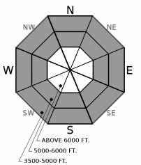
The avalanche danger remains elevated due to continued rain, dense snow, and winds. Sensitive slabs are thickening at higher elevations, while rain and wet snow are causing wet avalanche concerns lower in the terrain. Evaluate new snow totals and bonding with the underlying crust.

3. Considerable
?
Above 6500 ft.
2. Moderate
?
5000-6500 ft.
2. Moderate
?
3500-5000 ft.
- 1. Low
- 2. Moderate
- 3. Considerable
- 4. High
- 5. Extreme
-
Type ?
-
Aspect/Elevation ?

-
Likelihood ?CertainVery LikelyLikelyPossible
 Unlikely
 -
Size ?HistoricVery LargeLargeSmall

Up to 7" of dense snowfall yesterday and overnight are resting on up to 2' of less dense snow from earlier in the week. Continued dense snow and wind will form fresh slabs and add thickness to existing slabs. Observations from earlier in the week reported a poor bond between the surface snow and the underlying crust. Yesterday a rider triggered a slab avalanche which we assume ran on this crust. Evaluate new snow totals and the bond between the surface snow and the underlying crust. Cracking under your feet or machine is an obvious sign of an unstable slab. Wind-sheltered slopes less than 35 degrees offer the safest riding conditions.
-
Type ?
-
Aspect/Elevation ?

-
Likelihood ?CertainVery LikelyLikelyPossible
 Unlikely
 -
Size ?HistoricVery LargeLargeSmall

Yesterday morning air temperatures increased substantially which resulted in rollerballs and wet loose slides in the cold surface snow. A warm moist storm arrived in the afternoon depositing a rain/snow mix at lower elevations and dense snow above this. Observations were limited but we assume a small wet loose cycle occurred due to this moisture. Today, continued rain and dense snow will allow for the possibility of wet avalanches. Rollerballs and pinwheels are the first signs of instability. Use caution while riding above terrain traps and in long-running gullies.
The forecasted atmospheric river arrived as more of a babbling brook but still packed enough of a punch to elevate the avalanche danger. Yesterday morning/midday warm air ahead of the storm created a wet loose avalanche cycle in the relatively cold surface snow. The storm arrived in the afternoon slightly cooler than forecasted with the rain line remaining below 5000'. We assume the accompanying rain and dense snow resulted in an increase in natural wet loose and storm slab avalanche activity. The second round of precipitation will move into our area today with the rain line hovering around 4500'. Another 0.25 - 0.5" of precipitation will continue the threat of wet loose and storm slab avalanches. An inverted snow surface continues to form at mid and upper elevations with dense snow capping lower density snow from earlier in the week. Unfortunately, this snow is resting on a stout crust which will inhibit bonding.
The FAC will conclude daily advisories on April 8th. We will publish snowpack updates at 7 a.m. on Tuesday, Thursday, and Saturday mornings next week.
Another round of warm moisture will move into our area today. Precipitation tapers tonight with brief high-pressure building for Monday and Tuesday.
This advisory applies only to backcountry areas outside established ski area boundaries. This advisory describes general avalanche conditions and local variations always occur. This advisory expires at midnight on the posted day unless otherwise noted. The information in this advisory is provided by the USDA Forest Service who is solely responsible for its content.


