| Tuesday | Tuesday Night | Wednesday | |
|---|---|---|---|
| Cloud Cover: | Snow showers | Snow flurries | Snow showers increasing |
| Temperatures: | 32 to 37 deg. F. | 19 to 24 deg. F. | 35 to 40 deg. F. |
| Wind Direction: | SW | SW | SW |
| Wind Speed: | 0 to 10 mph | 0 to 10 mph | 0 to 10 mph |
| Snowfall: | 1 to 2 in. | 0 to 1 in. | 0 to 2 in. |
| Snow Line: |
Whitefish Range
Swan Range
Flathead Range and Glacier National Park
How to read the forecast
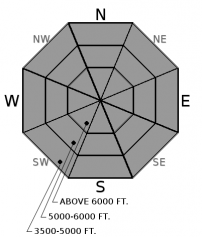
Yesterday, backcountry travelers easily triggered slab avalanches breaking in the new snow running on slick crusts. Expect more of the same today, especially in wind drifted areas or steep rollovers. Evaluate terrain consequences and bonding of the new snow carefully. Shooting cracks are a clear sign of unstable snow.

2. Moderate
?
Above 6500 ft.
2. Moderate
?
5000-6500 ft.
2. Moderate
?
3500-5000 ft.
- 1. Low
- 2. Moderate
- 3. Considerable
- 4. High
- 5. Extreme
-
Type ?
-
Aspect/Elevation ?

-
Likelihood ?CertainVery LikelyLikelyPossible
 Unlikely
 -
Size ?HistoricVery LargeLargeSmall

Monday's new snow is settling into cohesive storm slabs 6" to 18" thick over a variety of slick crusts. Observers yesterday reported poor bonding, shooting cracks, and easily triggered soft slabs and sluffs involving the storm snow. Watch for instabilities in leeward terrain and convexities at all elevations, especially in areas that saw favored snowfall. Use small test slopes and shear tests to assess storm totals and bonding before stepping out into consequential terrain. You can easily avoid the problem on slopes less than 35 degrees.
The April Fools storm wound down by yesterday afternoon, sending us strait back into winter. The storm delivered up to 20" in the Northern Whitefish Range, and 8" to 12" throughout the rest of the advisory area, ranging from .6" to 1.7" of SWE. Yesterday, observers reported the new snow was relatively low density and poorly bonded to underlying sun crusts and rain crusts. It sluffed easily in wind protected terrain and failed as soft slabs in wind affected terrain (see observation). Today, warming temperatures will consolidate the new snow into more cohesive and widespread storm slabs, while at the same time, bonding at the storm interface will gradually improve. This tug-of-war in the upper snowpack means that some slopes will stabilize and some can produce soft slab avalanches or loose dry avalanches in steep terrain. Areas that saw more snowfall or more windloading are capable of producing larger and more dangerous human triggered avalanches today. Pay close attention to storm totals, wind drifting patterns, and jump around on inconsequential steep slopes to gather data before traveling in larger terrain or above terrain traps.
Flow transitions to westerly for the next two days, bringing warmer temperatures and modest winds and snowfall. Mountain temperatures will climb from the low teens this morning into the upper 20s under light to moderate ridgetop winds. A few inches of snow is on tap for today and tomorrow.
This advisory applies only to backcountry areas outside established ski area boundaries. This advisory describes general avalanche conditions and local variations always occur. This advisory expires at midnight on the posted day unless otherwise noted. The information in this advisory is provided by the USDA Forest Service who is solely responsible for its content.


