| Thursday | Thursday Night | Friday | |
|---|---|---|---|
| Cloud Cover: | Clear to partly cloudy | Snow developing overnight | Snow |
| Temperatures: | 32 to 37 deg. F. | 23 to 28 deg. F. | 33 to 38 deg. F. |
| Wind Direction: | W | SW | W |
| Wind Speed: | 5 to 10 mph gusting to 25 mph | 10 to 15 mph gusting to 25 mph | 10 to 15 mph gusting to 25 |
| Snowfall: | 0 in. | 1 to 3 (N)/ 3 to 5 (S) in. | 2 to 4 in. |
| Snow Line: |
Whitefish Range
Swan Range
Flathead Range and Glacier National Park
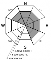
How to read the forecast
Thick wind slabs exist on leeward terrain features at mid and upper elevations. These slabs are more difficult to trigger today but are more extensive in distribution from unusually strong winds earlier in the week. Wind sheltered terrain offers the safest and best riding conditions today.

2. Moderate
?
Above 6500 ft.
2. Moderate
?
5000-6500 ft.
1. Low
?
3500-5000 ft.
- 1. Low
- 2. Moderate
- 3. Considerable
- 4. High
- 5. Extreme
-
Type ?
-
Aspect/Elevation ?

-
Likelihood ?CertainVery LikelyLikelyPossible
 Unlikely
 -
Size ?HistoricVery LargeLargeSmall

Strong to extreme southwest winds this week formed dense, thick wind slabs at mid and upper elevations. On Tuesday, several skier-triggered wind slabs were reported up to 2 ft thick along with shooting cracks traveling outward from the weight of a skier. Yesterday’s reprieve from snow and strong wind along with time are allowing these slabs to gain strength and become more stubborn to human triggering. Use caution when approaching wind-loaded terrain and anticipate slabs forming over larger areas. Look for lens-shaped pillows below ridgelines and on steep, convex or cross-loaded terrain. Surface cracking and shooting cracks are bulls-eye data of instability.
Yesterday’s winds eased off the gas pedal but a few mountain locations still observed strong gusts. The damage has already been done and dense, thick winds slabs are still the main problem today. A reprieve from significant loading yesterday combined with time is allowing newly formed wind slabs to gain strength and become more difficult to trigger. Anticipate these slabs to be found over larger areas and possibly further downslope after the prolonged period of strong winds and unusual drifting patterns. Use caution when approaching wind-loaded slopes and consider the consequences if traveling into bigger, more committing terrain. Stay alert for deeper drifts in terrain that is normally wind-sheltered while looking for lens-shaped pillows on steep convex or cross-loaded terrain. If the sun stays out for an extended period of time today, watch for rollerballs and pinwheels on steep, sunny aspects using that as a clue to move to shady aspects.
If you use our advisories, we encourage you to offer us feedback on this 5-minute survey. For those who participate, we are raffling off a pair of Zeal goggles on April 5th. Thanks!
Conditions dry out today across NW Montana with clearing skies this morning. Clouds will be on the increase this afternoon as our next storm system drops south out of Canada overnight. Winds should be light to moderate out of the west with a few strong gusts at upper elevations this afternoon. Temps will warm into the upper 20's to lower 30's above 5000 ft with no precipitation expected. Snowfall develops overnight initially favoring the Swan Range and continues through Friday. We can anticipate 5-10" of snow by Friday afternoon with locally higher amounts.
This advisory applies only to backcountry areas outside established ski area boundaries. This advisory describes general avalanche conditions and local variations always occur. This advisory expires at midnight on the posted day unless otherwise noted. The information in this advisory is provided by the USDA Forest Service who is solely responsible for its content.


