| Tuesday | Tuesday Night | Wednesday | |
|---|---|---|---|
| Cloud Cover: | Mix of rain and snow developing | Lingering showers | Partly cloudy |
| Temperatures: | 38 to 43 deg. F. | 23 to 28 deg. F. | 37 to 42 deg. F. |
| Wind Direction: | SW | W | W |
| Wind Speed: | 15 to 25 mph, gusting to 40 | 10 to 20 mph, gusting to 30 | 2 to 12 mph |
| Snowfall: | 0 to 2 in. | 0 to 2 in. | 0 in. |
| Snow Line: |
Whitefish Range
Swan Range
Flathead Range and Glacier National Park
How to read the forecast

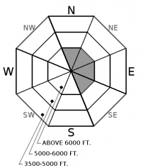
2. Moderate
?
Above 6500 ft.
1. Low
?
5000-6500 ft.
1. Low
?
3500-5000 ft.
- 1. Low
- 2. Moderate
- 3. Considerable
- 4. High
- 5. Extreme
-
Type ?
-
Aspect/Elevation ?

-
Likelihood ?CertainVery LikelyLikelyPossible
 Unlikely
 -
Size ?HistoricVery LargeLargeSmall

Strong to extreme west/southwest winds will accompany several inches of new snow in the forecast for today. Wind-drifted snow will form small, sensitive slabs below ridgelines, in gullies, or behind leeward terrain features. By this afternoon, these could become large enough to knock you off your feet and carry you into consequential terrain. Blowing snow or cracking underfoot are signs of fresh wind slab formation. You can easily avoid this problem by traveling in wind protected terrain.
Observations (or lack thereof) from the past few days highlight a stable snowpack coated by a mix of rain and sun crusts, windblown surfaces, and settled powder. A gusty weather system will bring changing conditions today. Weather models agree on a strong west to southwest wind component, which will transport any snow that is available for transport. A few inches of snowfall arrives later this afternoon, favoring Glacier Park and the Swan Range with up to 6". If your plans include the type of terrain where a small wind slab could have harsh consequences, pay attention to new snow amounts and watch for blowing and drifting snow to indicate fresh wind slab formation. Otherwise, enjoy another day of stable conditions in wind protected terrain.
If you use our advisories, we encourage you to offer us feedback on this 5-minute survey. For those who participate, we are raffling off a pair of Zeal goggles on April 5th. Thanks!
Northwesterly flow will continue to bring unsettled weather through the work week. A strong disturbance will bring snow showers and gusty winds today. Mountain temperatures are in the upper 20s this morning, and will rise through the day as freezing levels crest near 5,000'. Alpine wind will increase into the 20s and 30s, gusting to 50+ mph as the system brings light snowfall by midday. Quiet weather returns tomorrow under partly sunny skies.
This advisory applies only to backcountry areas outside established ski area boundaries. This advisory describes general avalanche conditions and local variations always occur. This advisory expires at midnight on the posted day unless otherwise noted. The information in this advisory is provided by the USDA Forest Service who is solely responsible for its content.


