| Monday | Monday Night | Tuesday | |
|---|---|---|---|
| Cloud Cover: | Clear with increasing clouds | Snow developing | Snow in the a.m. and again in the p.m. |
| Temperatures: | 32 to 37 deg. F. | 23 to 28 deg. F. | 35 to 40 deg. F. |
| Wind Direction: | SW | SW | SW |
| Wind Speed: | 5 to 15 mph gusting to 25 | 10 to 15 mph gusting to 30 | 10 to 20 mph gusting to 40 |
| Snowfall: | 0 in. | 1 to 2 in. | 1 to 3 in. |
| Snow Line: |
Whitefish Range
Swan Range
Flathead Range and Glacier National Park
How to read the forecast
The snowpack is generally stable. Watch for small pockets of unstable snow in leeward terrain. Continue to practice safe travel techniques.

1. Low
?
Above 6500 ft.
1. Low
?
5000-6500 ft.
1. Low
?
3500-5000 ft.
- 1. Low
- 2. Moderate
- 3. Considerable
- 4. High
- 5. Extreme
-
Type ?
-
Aspect/Elevation ?

-
Likelihood ?CertainVery LikelyLikelyPossible
 Unlikely
 -
Size ?HistoricVery LargeLargeSmall

Breezy conditions continue in the high country with Hornet reporting moderate winds with high gusts for the past 15 hours. However, wind slab development has ended due to limited snow available for transport. Yesterday's observations noted isolated wind slabs up to 18" thick and stubborn to triggering in central and southern Glacier Park. Today, watch for pockets of slabs on steep leeward terrain and convexities. Slabs may resemble lens-shaped drifts or pillow-like features. Hand pits easily identify bonding and reactivity of these slabs.
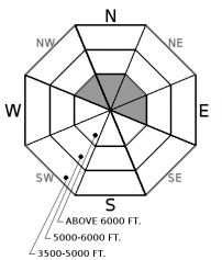
Limited observations confirm minimal new snow and nonreactive wind slabs. This is allowing us to drop the avalanche danger to LOW on upper elevation wind loaded (NW-E) slopes. Wind slabs exist at upper elevations and evaluating steep leeward terrain and convexities is recommended. The recent rain event formed a ~1" surface crust up to 6200' -7400' in the Whitefish and Flathead Range along with Glacier Park. On sunny aspects, solar input and warm temperatures formed a sun crust up to 10" thick. Unsettled weather returns this week with light snow tonight and Tuesday night. Concerns with the new snow will be the bond with the widespread crust. Even a brief appearance by the strong March sun may start wet avalanches in the new snow.
If you use our advisories, we encourage you to offer us feedback on this 5-minute survey. For those who participate, we're raffling off a pair of Zeal goggles with the drawing April 5th. Thanks!
A northwesterly flow pattern sets up later today and a more organized weather disturbance will move through impacting the northern Rockies this evening through Tuesday morning. Mountain passes may receive 3-5 inches of snow during this 24 hour period.
This advisory applies only to backcountry areas outside established ski area boundaries. This advisory describes general avalanche conditions and local variations always occur. This advisory expires at midnight on the posted day unless otherwise noted. The information in this advisory is provided by the USDA Forest Service who is solely responsible for its content.


