| Saturday | Saturday Night | Sunday | |
|---|---|---|---|
| Cloud Cover: | Snow developing | Snow tapering | Scattered snow showers |
| Temperatures: | 35 to 40 deg. F. | 18 to 23 deg. F. | 35 to 40 deg. F. |
| Wind Direction: | SW | S | SW |
| Wind Speed: | 10 to 15 mph gusting 25 mph | 5 to 15 mph gusting to 20 mph | 5 to 10 mph |
| Snowfall: | 2 to 4 in. | 0 to 2 in. | 0 to 1 in. |
| Snow Line: |
Whitefish Range
Swan Range
Flathead Range and Glacier National Park
How to read the forecast
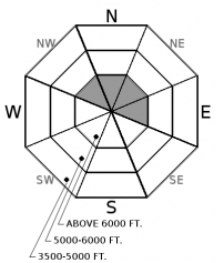
Instabilities within recently formed thin wind slabs exist at upper elevations. Wind and snow will add thickness to these slabs today. Generally, safe conditions exist in areas without wind loading. Evaluate all wind-loaded slopes especially in the alpine terrain. Surface cracking is a tell-tale sign of a slab.

2. Moderate
?
Above 6500 ft.
1. Low
?
5000-6500 ft.
1. Low
?
3500-5000 ft.
- 1. Low
- 2. Moderate
- 3. Considerable
- 4. High
- 5. Extreme
-
Type ?
-
Aspect/Elevation ?

-
Likelihood ?CertainVery LikelyLikelyPossible
 Unlikely
 -
Size ?HistoricVery LargeLargeSmall

Light snowfall Thursday night was limited to above 5500' with accumulations increasing with elevation. Southwest winds redistributed this snow forming thin slabs on a crust or settled snow. Today, light snow and moderate southwest winds will thicken these slabs. Slabs will be most reactive to a rider in locations where the bond with the underlying crust is poor. Yesterday, this crust was found on both sunny and shaded aspects at 6500' in the southern and northern Whitefish Range. Look for pillows of snow below ridgelines at upper elevations or on cross-loaded terrain. Cracking in the surface snow is an obvious sign of instability.
Yesterday, I toured in the southern Whitefish Range and found Thursday's cloudy warm humid weather formed a 1" melt-freeze crust on shady aspects at 6700'. We believe this is the first crust formed on upper elevation shady aspects from dry warm weather this season and truly a sign of spring. Chris was in the northern Whitefish Range where he noted a higher rain line with a rain crust at 6500'. We have not received any other observations and therefore have limited information on other areas. The storm forecast to affect us today does not have a lot of moisture associated with it but windy conditions could form fresh slabs and thicken existing slabs. In many locations, these slabs will rest on a crust adding to their instability.
Sunny aspects at all elevations have been affected by this month's sunny warm weather. This has lead to several wet loose avalanche cycles and a strong near-surface snowpack. Shady aspects at low and mid elevations have benefitted from warm air temperatures and rain which has strengthened the upper pack. At upper elevations, the near-surface is also consolidating but at a slower rate. Instabilities can still be found on this side of the compass. Yesterday, on a wind-loaded slope, I found a buried surface hoar layer 14" from the surface. This layer formed during a clear weather period prior to Monday's storm. In my Extended Column Test propagation occurred with easy force (ECTP6). This proves that the recent benign weather has not eliminated all weak layers buried below the surface and we still recommend digging to evaluate the near-surface snow.
If you use our advisories, we encourage you to offer us feedback on this 5-minute survey. For those who participate, we're raffling off a pair of Zeal goggles with the drawing April 5th. Thanks!
A weak storm moves into our area today depositing light snow with the freezing level at the valley floor. Unsettled weather continues tonight into tomorrow with scattered flurries and cool temperatures.
This advisory applies only to backcountry areas outside established ski area boundaries. This advisory describes general avalanche conditions and local variations always occur. This advisory expires at midnight on the posted day unless otherwise noted. The information in this advisory is provided by the USDA Forest Service who is solely responsible for its content.


