| Friday | Friday Night | Saturday | |
|---|---|---|---|
| Cloud Cover: | Mostly clear trending to partly cloudy by afternoon | Mostly cloudy | Snow developing in the morning |
| Temperatures: | 37 to 42 deg. F. | 20 to 25 deg. F. | 30 to 35 deg. F. |
| Wind Direction: | SW | S | SW |
| Wind Speed: | 10 to 15 mph gusting 25 mph | 5 to 10 mph | 10 to 15 mph gusting 30 mph |
| Snowfall: | 0 in. | 0 in. | 2 to 3 in. |
| Snow Line: |
Whitefish Range
Swan Range
Flathead Range and Glacier National Park
How to read the forecast

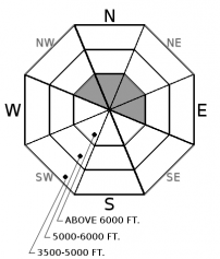
2. Moderate
?
Above 6500 ft.
1. Low
?
5000-6500 ft.
1. Low
?
3500-5000 ft.
- 1. Low
- 2. Moderate
- 3. Considerable
- 4. High
- 5. Extreme
-
Type ?
-
Aspect/Elevation ?

-
Likelihood ?CertainVery LikelyLikelyPossible
 Unlikely
 -
Size ?HistoricVery LargeLargeSmall

Moderate southwest winds with strong gusts accompanied the cold front passage overnight along with a transition from light rain to snow. Weather stations are reporting rain or a rain-snow mix up to 6000 ft with light snow accumulations (1 – 4”) throughout the advisory area. Thin, newly formed wind slabs may be reactive to the weight of a skier or rider at upper elevations. These slabs are most likely located below ridgelines and on steep convex or cross-loaded terrain. Look for cracks in the snow surface as a sign of instability and steer around lens-shaped drifts. This problem can be identified by hand pits and quickly test bonding of new snow. A small wind slab triggered in high consequence terrain can have a bad outcome.
Rain, snow, and moderate southwest winds describe the mountain weather over the past 24 hours. Weird weather can give way to weird avalanches, so remain diligent in your snowpack assessments despite light liquid and snow accumulations. Weather stations are reporting light rain (0.05 – 0.3”) up to 6000 ft yesterday with precipitation quickly changing to snow overnight. Snow accumulations range from 1 – 4” at upper elevations and lesser amounts at mid/ lower elevations. Wind can load slopes 10 times faster than snow falling from the sky, so anticipate deeper drifts of snow on leeward slopes from moderate southwest winds and strong gusts.
Mid/ lower elevations snow surfaces became wet from the rain yesterday but also experienced a short re-freeze overnight. This should make for challenging uphill and downhill travel today on a breakable surface crust. Cloud models are forecasting sunny skies today along with above freezing temps below 6000 ft. Combined with rain from yesterday, a small loose wet avalanche is unlikely but possible on sunny aspects that didn’t produce loose wet activity on Wednesday. Continue using caution around terrain traps, gullies, and cliffs with higher consequences.
If you use our advisories, we encourage you to offer us feedback on this 5-minute survey. For those who participate, we're raffling off a pair of Zeal goggles with the drawing April 5th. Thanks!
Today is a transition day before another cold front along with snow and wind arrive overnight. Clear skies today should allow temps to warm into the upper 20's F above 6000 ft and upper 30's to lower 40's F below. Winds will be light to moderate out of the southwest with occasional gusts of 30 mph above 6000 ft. Widespread snowfall develops overnight and tomorrow with new snow accumulations of 3-5" with locally higher amounts.
This advisory applies only to backcountry areas outside established ski area boundaries. This advisory describes general avalanche conditions and local variations always occur. This advisory expires at midnight on the posted day unless otherwise noted. The information in this advisory is provided by the USDA Forest Service who is solely responsible for its content.


