THIS AVALANCHE FORECAST EXPIRED ON March 22, 2018 @ 12:07 am
Avalanche Forecast published on March 21, 2018 @ 7:07 am
Issued by Zach Guy - Flathead Avalanche Center

Whitefish Range
Swan Range
Flathead Range and Glacier National Park

How to read the forecast

Recent storm snow continues to consolidate.  If the sun comes out today, watch for wet sluffs on sunny aspects and the danger to rise to MODERATE.  Use caution around gullies and terrain traps if you see rollerballs or pinwheels.

2. Moderate

?

Above 6500 ft.
Heightened avalanche conditions on specific terrain features. Evaluate snow and terrain carefully; identify features of concern.

2. Moderate

?

5000-6500 ft.
Heightened avalanche conditions on specific terrain features. Evaluate snow and terrain carefully; identify features of concern.

1. Low

?

3500-5000 ft.
Generally safe avalanche conditions. Watch for unstable snow on isolated terrain features.
    Heightened avalanche conditions on specific terrain features. Evaluate snow and terrain carefully; identify features of concern.
  • 1. Low
  • 2. Moderate
  • 3. Considerable
  • 4. High
  • 5. Extreme
Avalanche Problem 1: Loose Wet
  • Type ?
  • Aspect/Elevation ?
  • Likelihood ?
    Certain
    Very Likely
    Likely
    Possible
    Unlikely
  • Size ?
    Historic
    Very Large
    Large
    Small

The snow surface remains soft and vulnerable to loose wet avalanches if it moistens under strong solar radiation.   With sunshine in the forecast for this morning, watch for the recent snow to sluff off of steep, sunbaked slopes.    Pay attention to cloud cover and look for rollerballs, pinwheels, or point releases from rocky areas as signs of instability.  If the sun is out, use caution around gullies, cliffs, or other consequential terrain.  

Avalanche Problem 2: Storm Slab
  • Type ?
  • Aspect/Elevation ?
  • Likelihood ?
    Certain
    Very Likely
    Likely
    Possible
    Unlikely
  • Size ?
    Historic
    Very Large
    Large
    Small

The foot of snow that fell on Monday is generally consolidating and bonding well to underlying surfaces.  Watch for isolated instabilities, especially behind leeward terrain features or on convexities.  Look for cracking to identify unstable snow.  

Forecast discussion

Cloud cover over all but the Southern Swan Range prevented wet loose activity from developing yesterday. This preserved the dry and powdery snow surface at upper elevations, which remains vulnerable to wet loose avalanches if the sun comes out.  The accuracy of today's forecast teeters on another challenging cloud forecast.  It looks like we'll see a mix of sun breaking through patchy clouds this morning, before a thicker shield of clouds arrives this afternoon. Temperatures should be about 5 degrees warmer than yesterday.  If the forecast verifies, southeasterly aspects will catch the brunt of solar-induced wet loose action this morning before activity shuts off this afternoon.  The storm snow is consolidating and the expected size of wet loose activity is decreasing, but we could see some D2s sluffing out of longer running terrain if the snow surface warms up rapidly this morning.    

If we remain under good cloud cover, or on shaded aspects, your primary concern is watching for slabs or dry sluffs involving the new snow, which is generally 6" to 15" deep around our forecast area.  Observers are reporting good bonding with minimal signs of instability.  You may encounter some recent wind drifting near ridgelines or pockets of unstable snow in steep, variable terrain.  Remain vigilant in your snowpack assessments.  


Weather and CURRENT CONDITIONS
weather summary

Cloud cover will increase this morning ahead of the next Pacific system.  Mountain temperatures will rise from the mid 20s to mid 30s today under calm winds.  A mix of rain and snow kicks off on Thursday with freezing levels lowering through Thursday night.  

Two-Day Mountain Weather Forecast Produced in partnership with the Missoula NWS
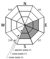
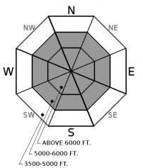
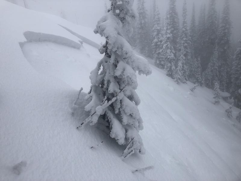
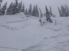
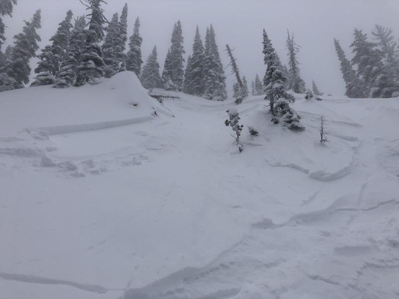
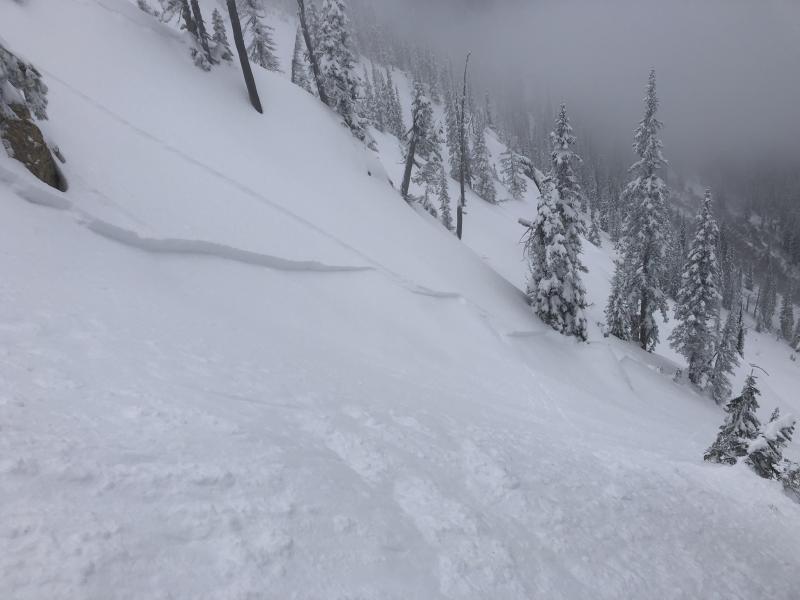
For 5000 ft. to 7000 ft.
Wednesday Wednesday Night Thursday
Cloud Cover: Increasing clouds Isolated showers Rain developing
Temperatures: 40 to 45 deg. F. 30 to 35 deg. F. 45 to 50 deg. F.
Wind Direction: SW S S
Wind Speed: 0 to 5 0 to 5 0 to 5
Snowfall: 0 in. 0 in. 0 in.
Snow Line:
Disclaimer

This advisory applies only to backcountry areas outside established ski area boundaries. This advisory describes general avalanche conditions and local variations always occur. This advisory expires at midnight on the posted day unless otherwise noted. The information in this advisory is provided by the USDA Forest Service who is solely responsible for its content.