| Tuesday | Tuesday Night | Wednesday | |
|---|---|---|---|
| Cloud Cover: | Decreasing clouds | Partly cloudy | Warming and partly cloudy |
| Temperatures: | 40 to 45 deg. F. | 19 to 24 deg. F. | 43 to 48 deg. F. |
| Wind Direction: | SW | SW | SW |
| Wind Speed: | 2 to 12 | 2 to 12 | 0 to 10 |
| Snowfall: | 0 in. | 0 in. | 0 in. |
| Snow Line: |
Whitefish Range
Swan Range
Flathead Range and Glacier National Park
How to read the forecast
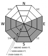
Over a foot of new snow will destabilize quickly if the sun makes a strong appearance. Anticipate large loose wet avalanches to release naturally on steep, sunny slopes. Monitor for fresh storm instabilities on all aspects.

3. Considerable
?
Above 6500 ft.
3. Considerable
?
5000-6500 ft.
2. Moderate
?
3500-5000 ft.
- 1. Low
- 2. Moderate
- 3. Considerable
- 4. High
- 5. Extreme
-
Type ?
-
Aspect/Elevation ?

-
Likelihood ?CertainVery LikelyLikelyPossible
 Unlikely
 -
Size ?HistoricVery LargeLargeSmall

Over a foot of new snow accumulated over a sun crust yesterday. On sunbaked slopes, the new snow will sluff easily as the snow surface warms. With a substantial amount of snow to entrain, these slides could become surprisingly powerful as they run downslope, or they could trigger slab avalanches. Rollerballs, pinwheels, or point release slides are obvious signs of instability. Pay attention to surface warming and move to shadier aspects if the sun comes out. Be mindful of overhead hazards, especially below long-running gullies.
-
Type ?
-
Aspect/Elevation ?

-
Likelihood ?CertainVery LikelyLikelyPossible
 Unlikely
 -
Size ?HistoricVery LargeLargeSmall

1 to 2 feet of new snow is settling into a cohesive storm slab on a variety of surfaces. An observer yesterday reported easily triggered soft slabs breaking in the new snow. The sensitivity of storm slabs will vary from slope to slope, depending on bonding, storm totals, wind loading, and solar input. Carefully monitor for storm instabilities and consider terrain consequences before traveling on slopes steeper than 35 degrees. You can gather information from smaller test slopes, hand pits, or by looking for cracking in the new snow.
The last official day of winter exited triumphantly, dropping significant storm totals around all three ranges. Stations or observers reported 10" to 15" in the Whitefish Range (Up to 2.3" SWE), over 16" in the Swan Range (2.4" SWE), and 6" to 12" in the Flathead and GNP (1.4" SWE). Winds were generally light to moderate out of the southwest during the storm, which ended yesterday evening. Despite this impressive loading event, the new snow displayed a mix of storm slab concerns yesterday: Observers found good bonding or incohesive snow in some areas, while others noted propagating stability tests or easily triggered soft slabs. Today, you are most likely to encounter storm slab instabilities on convex rollovers, leeward terrain features, or on slopes where the sun rapidly settles the new snow.
Today's avalanche danger hinges on whether the sun strikes hard. There is now an impressive volume of new, unconsolidated snow waiting to peel off of the most recently buried sun crust. If the sun initiates a loose wet avalanche cycle, we can expect numerous D2s and dangerous avalanche conditions to develop today. Cloud forecasts are suggesting a clearing mid-day as temperatures reach near freezing up high. Pay attention to cloud cover and surface warming, and plan your routes to avoid going beneath steep southerly-facing slopes when and if the new snow starts to shed.
The spring equinox brings a mix of warming temperatures and partly cloudy skies. Clouds are forecasted to break apart by mid day and temperatures will rise from the upper 20s to low 30s under light to moderate winds. Tomorrow brings a similar, but warmer pattern.
This advisory applies only to backcountry areas outside established ski area boundaries. This advisory describes general avalanche conditions and local variations always occur. This advisory expires at midnight on the posted day unless otherwise noted. The information in this advisory is provided by the USDA Forest Service who is solely responsible for its content.


