| Saturday | Saturday Night | Sunday | |
|---|---|---|---|
| Cloud Cover: | Increasing clouds | Light snow | Mostly cloudy with snow decreasing |
| Temperatures: | 40 to 45 deg. F. | 20 to 25 deg. F. | 35 to 40 deg. F. |
| Wind Direction: | E | NE | NE |
| Wind Speed: | 0 to 5 mph | 0 to 5 mph | 5 to 10 mph |
| Snowfall: | 0 in. | 0 to 2 in. | 0 to 1 in. |
| Snow Line: |
Whitefish Range
Swan Range
Flathead Range and Glacier National Park
How to read the forecast
The avalanche danger is LOW this morning. The danger will rise to MODERATE above 5000' with warm and sunny weather creating thin wet avalanches. Move to a shady aspect as the snow surface softens. Lingering shallow storm instabilities exist at mid and upper elevations.

2. Moderate
?
Above 6500 ft.
2. Moderate
?
5000-6500 ft.
1. Low
?
3500-5000 ft.
- 1. Low
- 2. Moderate
- 3. Considerable
- 4. High
- 5. Extreme
-
Type ?
-
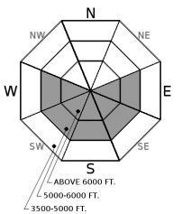
Aspect/Elevation ?

-
Likelihood ?CertainVery LikelyLikelyPossible
 Unlikely
 -
Size ?HistoricVery LargeLargeSmall

Our recent storm favored Glacier Park and the Swan Range where up to 8" of new snow fell above 5000'. Yesterday's solar input and warm weather triggered a small wet loose cycle on sunny aspects at mid and upper elevations. The stout sun crust formed earlier in the week acted as a slippery bed surface for these slides. With sunshine and warming today small wet loose activity is expected particularly in areas favored by the recent storm. The deterioration of the surface crust and accompanying sloppy conditions are a sign you have lingered too long and need to move to a shadier aspect. Avoid traveling above terrain traps and long-running gullies after they soften.
-
Type ?
-
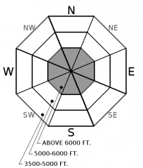
Aspect/Elevation ?

-
Likelihood ?CertainVery LikelyLikelyPossible
 Unlikely
 -
Size ?HistoricVery LargeLargeSmall

A small shallow storm slab cycle occurred during our recent storm. Up to 8" of dense snow fell on a stout sun crust on sunny aspects and consolidated powder or an isolated surface hoar layer on shady aspects. This problem is healing quickly but be aware of lingering instabilities particularly on leeward aspects where the slab will be thicker. This is a thin surface problem that can be identified by hand pits and signs of instability such as cracking. Evaluate areas with new snow before committing to steeper and larger terrain.
The recent storm was fickle and appeared to have favored the Swan and west central Glacier Park. A thin storm slab and wet loose cycle were noted in Glacier Park yesterday (observation). Accompanying debris was small and D1-1.5 in size. I was outside of Essex yesterday and found just 2" of new snow at 7400' with no new snow below 5700'. Today there is a storm system to our south that will spread clouds into our area as the day progresses. Our loose wet problem will be determined by the extent of cloud cover. With continued clear skies the danger will rise to MODERATE as warming and solar input increase the threat of shallow wet avalanches. Our storm slab problem will be confined to isolated upper elevation slopes that received the most snow Thursday night. The dense nature of this snow along with yesterdays warming is allowing this problem to heal quickly.
There is a storm system to our south that will send clouds and eventually a little precipitation our way. Precipitation should start later this evening and end by Sunday morning with just minimal accumulations. Cooler and cloudier weather is expected tomorrow.
This advisory applies only to backcountry areas outside established ski area boundaries. This advisory describes general avalanche conditions and local variations always occur. This advisory expires at midnight on the posted day unless otherwise noted. The information in this advisory is provided by the USDA Forest Service who is solely responsible for its content.


