| Friday | Friday Night | Saturday | |
|---|---|---|---|
| Cloud Cover: | Snow | Snow decreasing by evening | Clear to partly cloudy |
| Temperatures: | 32 to 37 deg. F. | 15 to 20 deg. F. | 32 to 37 deg. F. |
| Wind Direction: | SW | W | SW |
| Wind Speed: | 15 to 20 mph gusting to 40 mph | 10 to 15 mph gusting to 35 mph | 0 to 5 mph |
| Snowfall: | 2 to 4 in. | 0 to 1 in. | 0 in. |
| Snow Line: |
Whitefish Range
How to read the forecast
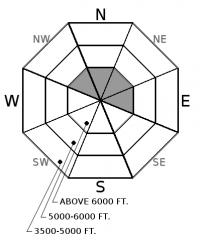
Heavy, dense snow and moderate southwest winds formed sensitive storm slabs at mid/ upper elevations. Slabs will thicken through the day especially at upper elevations on leeward slopes. A human triggered avalanche is likely on slopes steeper than 35 degrees. Look for cracking in the snow surface as a sign of instability. Safer riding conditions exist in lower elevation, wind-sheltered terrain.

3. Considerable
?
Above 6500 ft.
3. Considerable
?
5000-6500 ft.
2. Moderate
?
3500-5000 ft.
- 1. Low
- 2. Moderate
- 3. Considerable
- 4. High
- 5. Extreme
-
Type ?
-
Aspect/Elevation ?

-
Likelihood ?CertainVery LikelyLikelyPossible
 Unlikely
 -
Size ?HistoricVery LargeLargeSmall

24-hour snowfall totals approaching a foot and over an inch of SWE formed sensitive storm slabs at mid and upper elevations. Sunny aspect harboring a sun crust will act as a slippery bed surface for storm slabs to run fast and far. Storm slabs are easily triggered by the weight of a skier or rider, can fail naturally, and become thicker and more widespread throughout the day. Shady aspects with consolidated powder will allow better bonding with the new snow and can be evaluated with hand pits. Evaluate storm totals and test small slopes before going into steeper terrain while looking for cracks in new snow as a sign of instability.
-
Type ?
-
Aspect/Elevation ?

-
Likelihood ?CertainVery LikelyLikelyPossible
 Unlikely
 -
Size ?HistoricVery LargeLargeSmall

Dense snow combined with moderate southwest winds gusting over 30 mph formed wind slabs at upper elevations. Skiers in the Flathead Range yesterday found 2-6” wind slabs reactive on leeward slopes and running several hundred feet downslope. These slabs will become thicker and more widespread today with additional snow and wind. Avoid lens-shaped pillows below ridgelines and on steep convex or cross-loaded terrain. Cracking in the snow is a sign of instability. A small wind slab triggered in high consequence terrain can have a bad outcome.
Snow started falling yesterday morning with observations hinting at 2-4” throughout our forecast area with a lull in snowfall yesterday afternoon. Snow and moderate southwest winds arrived overnight with 24-hour snowfall totals range from around one foot in the Whitefish Range, 3” at Noisy Basin, 3-4” in the Flathead Range, and 8” at Flattop in GNP. New, dense snow is adding an additional 0.5-1.25” SWE to our snowpack forming sensitive storm slabs making human triggering likely on slopes steeper than 35 degrees. Wind slabs will be overlapping these storm slabs on leeward slopes at upper elevations.
Observations continue to point at a strong upper snowpack structure (ob 1, ob 2) with the 2/8 rain crust and 2/14 facets being our closest weak layer to the surface. This layer hasn’t produced an avalanche in several weeks and facets are showing signs of rounding. With an additional 3-5” and near 0.5” SWE today, I don’t expect this new load to reactivate the buried crust/ facet combo. Today’s avalanche problems are most likely confined to the upper snowpack but shouldn’t be treated as any less significant. Evaluate storm totals with quick pits and test small slopes before going into bigger terrain. A small, human triggered storm or wind slab in high consequence terrain could have a bad outcome. Have situational awareness around terrain traps and gullies and anticipate changing conditions throughout the day and with elevation.
Deep slab instabilities have been dormant for nearly a month. Continue to give cornices a wide berth; they have grown to dangerously large sizes this season and can also act as triggers for larger avalanches (photo). Cornices are more sensitive to human or natural failures during heavy loading and warmer temperatures like today.
Don't miss out on our final two avalanche education lectures this season at Penco Power Products in Kalispell and Whistling Andy Distillery in Bigfork. Thanks to all who participated in our avalanche education program this season and we're already planning next years line-up!
At 4 am, a cold front is positioned north to south in central Washington with an associated low-pressure system in south-central British Columbia. Widespread precipitation is being observed ahead of the cold front across ID and northwest MT. Snow levels today will start out between 4000-5000 ft and will drop with the cold front passage. Highest precipitation rates are expected between 9-12 pm today with a shift to showery precipitation this afternoon and evening. Winds are forecasted to remain moderate to strong out of the W-SW through this evening with an additional 3-5" of snow by tonight. High pressure sets up Saturday through Monday with sunny and dry conditions on tap.
This advisory applies only to backcountry areas outside established ski area boundaries. This advisory describes general avalanche conditions and local variations always occur. This advisory expires at midnight on the posted day unless otherwise noted. The information in this advisory is provided by the USDA Forest Service who is solely responsible for its content.


