| Wednesday | Wednesday Night | Thursday | |
|---|---|---|---|
| Cloud Cover: | Mostly clear and warm | Increasing clouds | Light snow |
| Temperatures: | 35 to 40 deg. F. | 20 to 25 deg. F. | 35 to 40 deg. F. |
| Wind Direction: | SW | SW | SW |
| Wind Speed: | 0 to 10 | 0 to 10 | 0 to 10 |
| Snowfall: | 0 in. | 0 in. | 0 to 2 in. |
| Snow Line: |
Whitefish Range
Swan Range
Flathead Range and Glacier National Park
How to read the forecast
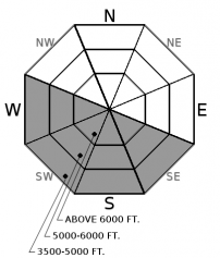
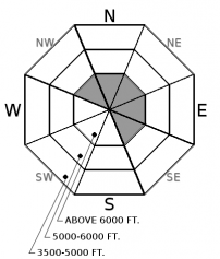
Warming temperatures and sunshine will increase the avalanche danger to MODERATE. Be cautious of small loose wet avalanches running from steep, sunlit faces and gullies. Shaded aspects offer better stability and snow quality, but watch for isolated wind drifts at higher elevations and give massive cornices their due space.

2. Moderate
?
Above 6500 ft.
2. Moderate
?
5000-6500 ft.
1. Low
?
3500-5000 ft.
- 1. Low
- 2. Moderate
- 3. Considerable
- 4. High
- 5. Extreme
-
Type ?
-
Aspect/Elevation ?

-
Likelihood ?CertainVery LikelyLikelyPossible
 Unlikely
 -
Size ?HistoricVery LargeLargeSmall

Direct sunshine and warming temperatures will moisten the snow surface, causing it to sluff naturally on some steep, sunny slopes. Today's wet loose avalanches should entrain only the top few inches of new snow, but they could be hazardous above cliff bands or in long-running gullies that funnel debris (See video). Rollerballs and point-releases from rocky areas signal changing conditions. You can avoid this problem on cold, shady aspects.
-
Type ?
-
Aspect/Elevation ?

-
Likelihood ?CertainVery LikelyLikelyPossible
 Unlikely
 -
Size ?HistoricVery LargeLargeSmall

Gusty southwest winds accompanied a few inches of snow on Monday. This formed shallow pockets of wind drifted snow behind leeward terrain features at high elevations. Yesterday, a skier triggered a small wind slab in the Flathead Range. These slabs are isolated and gaining strength, but pay attention to recent or active drifting patterns and look for cracking if you are traveling in consequential terrain.
Up to five inches of new snow has accumulated since Monday morning, On sunny aspects, the new snow will readily sluff off in steep terrain as it moistens above a buried sun crust. This will start this morning on east or southeasterly aspects and work its way around to south and west aspects as the day goes on. Many slopes don't have enough snow over the buried sun crust to pose a significant threat, but use caution around terrain traps and couloirs, where small wet loose avalanches can pack a punch. Pay attention to how much recent snow you find and how quickly the surface is warming while minding your overhead hazards. Or simply ride in the shade where you'll find better powder.
On shady aspects, instabilities are more isolated. Our forecasters were in the Swan Range yesterday and Northern Whitefish on Monday and couldn't find signs instability in the new snow. However, a skier in the Middle Fork triggered a shallow wind slab yesterday. Keep a sharp eye for pockets of unstable snow lingering from Monday's snow squalls and gusty winds. We could see enough wind today to cause snow transport off of the high peaks.
Deep slab instabilities have been dormant for nearly a month. Continue to give cornices a wide berth; they have grown to dangerously large sizes this season and can also act as triggers for larger avalanches (photo). Cornices are more sensitive to human or natural failures during warm weather like today.
Skies are mostly clear this morning under light to moderate winds, and mountain temperatures are in the low 20s. Temperatures will rise near or above freezing under sunny skies today, offering a nice preview of the warm, sunny weather on tap for the weekend and beyond. Before then, a disturbance will bring gusty winds and snowfall on Thursday and Friday.
This advisory applies only to backcountry areas outside established ski area boundaries. This advisory describes general avalanche conditions and local variations always occur. This advisory expires at midnight on the posted day unless otherwise noted. The information in this advisory is provided by the USDA Forest Service who is solely responsible for its content.


