| Tuesday | Tuesday Night | Wednesday | |
|---|---|---|---|
| Cloud Cover: | Convective snow showers | Partly cloudy | Clearing skies |
| Temperatures: | 29 to 34 deg. F. | 5 to 10 deg. F. | 33 to 38 deg. F. |
| Wind Direction: | SW | SW | SW |
| Wind Speed: | 0 to 10 | 0 to 10 | 0 to 10 |
| Snowfall: | 1 to 2 in. | 0 in. | 0 in. |
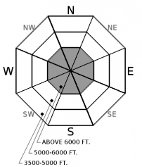
| Snow Line: |
Whitefish Range
Swan Range
Flathead Range and Glacier National Park
How to read the forecast
The snowpack is generally stable. Watch for small pockets of unstable snow in high consequence terrain. Continue to practice safe travel techniques.

1. Low
?
Above 6500 ft.
1. Low
?
5000-6500 ft.
1. Low
?
3500-5000 ft.
- 1. Low
- 2. Moderate
- 3. Considerable
- 4. High
- 5. Extreme
-
Type ?
-
Aspect/Elevation ?

-
Likelihood ?CertainVery LikelyLikelyPossible
 Unlikely
 -
Size ?HistoricVery LargeLargeSmall

Gusty southwest winds accompanied up to 4" of dense snow yesterday. This formed shallow lenses of wind drifted snow below ridgelines or in steep gullies at high elevations. Instabilities are most likely to be found where wind drifting overlaps with slick sun crusts that formed earlier in the week (See video). Pay attention to drifting patterns on the surface of the snow and look for cracking to identify the problem. A small slide can have bad consequences if it drags you down a couloir, over rock bands, or into trees.
Yesterday's intense but short-lived snow bands favored the Swan Range and brought a few inches of snow to the rest of the forecast area. Noisy Basin picked up 4" (.6" SWE), with smaller totals elsewhere. Some weather stations showed strong southwest wind gusts yesterday which eased overnight. A couple observations from yesterday pointed towards stable conditions, but I suspect there were small wind slabs forming somewhere in the alpine. Any instabilities should be fairly short-lived, but something to watch for if you are riding or climbing in high consequence terrain. Today's weather brings continued convective showers under calm winds, with only a couple inches in the forecast. Spring weather is fickle. Watch for localized heavy snowfall rates interrupted by periods of sun, which could cause small sluffs.
Deep slab instabilities have been dormant for nearly a month. Continue to give cornices a wide berth; they have grown to dangerously large sizes this season and can also act as triggers for larger avalanches (photo).
<
A low-pressure system is making its exit towards the Midwest with high pressure in its wake. We will see continued bands of short-lived, but intense convective snow showers today. Clearing skies tonight will drop the mercury close to single digits, but temperatures will be spring-like tomorrow.
This advisory applies only to backcountry areas outside established ski area boundaries. This advisory describes general avalanche conditions and local variations always occur. This advisory expires at midnight on the posted day unless otherwise noted. The information in this advisory is provided by the USDA Forest Service who is solely responsible for its content.


