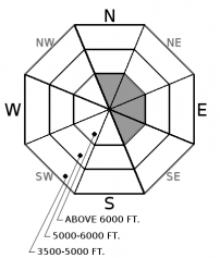
| Sunday | Sunday Night | Monday | |
|---|---|---|---|
| Cloud Cover: | Increasing clouds and cooler | Light snow developing | Light snow |
| Temperatures: | 23 to 28 deg. F. | 13 to 18 deg. F. | 25 to 30 deg. F. |
| Wind Direction: | N | SW | SW |
| Wind Speed: | 1 to 11 mph | 1 to 11 mph | 5 to 10 mph, gusts to 20 |
| Snowfall: | 0 to 1 in. | 0 to 2 in. | 2 to 4 in. |
| Snow Line: |
Whitefish Range
Swan Range
Flathead Range and Glacier National Park
How to read the forecast
The combination of yesterday's sunny warm weather and this morning's cold dry conditions has allowed the surface snowpack to gain strength. The avalanche danger is LOW. Watch for thin wind slabs on leeward aspects at upper elevations. Stay well away from cornices weakened during Saturday's warming. Continue to practice safe travel techniques.

1. Low
?
Above 6500 ft.
1. Low
?
5000-6500 ft.
1. Low
?
3500-5000 ft.
- 1. Low
- 2. Moderate
- 3. Considerable
- 4. High
- 5. Extreme
-
Type ?
-
Aspect/Elevation ?

-
Likelihood ?CertainVery LikelyLikelyPossible
 Unlikely
 -
Size ?HistoricVery LargeLargeSmall

Light southwest winds transported Friday's snowfall forming thin wind slabs at upper elevations. Slabs will be thickest in the Whitefish and the Swan Range where up to 10" of snow was recorded. Yesterday's warm weather has allowed these slabs to gain strength but remain cognizant of lingering instabilities. Today's forecasted light winds should limit wind slab formation but note wind transport in areas you are riding. Cracking in the snow surface is a sign of instability. Use small test slopes before committing to bigger, more aggressive terrain.
Yesterday, the Flathead experienced a warm bluebird day for the first time in what seems to be "forever". West Glacier was the warm spot with a balmy 48 while most upper elevation stations reported below freezing temperatures. Overcast skies broke mid-morning initiating a small wet loose avalanche cycle on sunny aspects at all elevations. Observations were sparse but activity appears to be widespread. Warming temperatures allowed trees to shed snow resulting in tree bombs that initiated rollerballs/pinwheels or loose avalanches. Solar input warmed rock outcroppings leading to similar results. Efficient radiational cooling overnight formed a surface crust on slopes moistened yesterday. Cooler temperatures and increasing cloud cover will limit the wet loose problem today.
Wind slabs are the only avalanche problem that we are listing in today's advisory. These formed Friday night/Saturday morning and have gained strength due to yesterday's warm weather. Yesterday, our forecasters traveled to high elevations in the Whitefish Range and the Flathead Range and noted previous light snow transport with isolated wind drifts just below alpine ridgelines. If you recreate in true alpine terrain today please let us know what you see. Observations can be easily submitted here: http://www.flatheadavalanche.org/node/add/observation
Due to a sharp decline in local deep slab avalanche activity, supplemented by a lack of explosive results at a regional scale, suggests deep instabilities are dormant under our current weather patterns. We have removed the problem for now but will bring it back when we see another big loading event or spring thaw. Forecasting for deep slabs carries a large amount of uncertainty. We remain uneasy about the potential for a cornice-fall triggered deep slab in the alpine terrain of the Flathead Range and Glacier Park. This blog post provides more insight into the problem.
Yesterday's warm sunny day lead to a cold clear night. Today a cooler day with increasing clouds should be expected. Light snowfall returns tonight into tomorrow.
This advisory applies only to backcountry areas outside established ski area boundaries. This advisory describes general avalanche conditions and local variations always occur. This advisory expires at midnight on the posted day unless otherwise noted. The information in this advisory is provided by the USDA Forest Service who is solely responsible for its content.


