| Saturday | Saturday Night | Sunday | |
|---|---|---|---|
| Cloud Cover: | Partly cloudy | Cold and dry | Partly cloudy and cool |
| Temperatures: | 25 to 30 deg. F. | 5 to 10 deg. F. | 22 to 27 deg. F. |
| Wind Direction: | SW | E | E |
| Wind Speed: | 1 to 11 mph | 0 to 10 mph | 0 to 10 mph |
| Snowfall: | 0 in. | 0 in. | 0 in. |
| Snow Line: |
Whitefish Range
Swan Range
Flathead Range and Glacier National Park
How to read the forecast
Yesterday's storm was intense but short-lived. Thin storm slabs formed on all aspects but will be thickest below ridgelines. Loose snow slides may be human triggered on steep slopes or initiate naturally with prolonged solar input. Evaluate the bonding of new snow to the old snow surface. Cracking under your feet or machine is an obvious sign of instability.

2. Moderate
?
Above 6500 ft.
2. Moderate
?
5000-6500 ft.
2. Moderate
?
3500-5000 ft.
- 1. Low
- 2. Moderate
- 3. Considerable
- 4. High
- 5. Extreme
-
Type ?
-
Aspect/Elevation ?

-
Likelihood ?CertainVery LikelyLikelyPossible
 Unlikely
 -
Size ?HistoricVery LargeLargeSmall

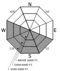
Up to 10" of snow fell during yesterday's storm favoring the Whitefish Range and Noisy Basin. Thin storm slabs formed on generally soft surfaces which will promote a faster healing process. Light to moderate winds shifted from the northeast to southwest during the storm resulting in loading on both east and west leeward slopes. Slabs will be thickest below ridgelines and in gulley features. Utilize hand pits to determine new snow bonding. Cracking in the snow surface is a sign of instability. Use small test slopes before committing to bigger, more aggressive terrain.
-
Type ?
-
Aspect/Elevation ?

-
Likelihood ?CertainVery LikelyLikelyPossible
 Unlikely
 -
Size ?HistoricVery LargeLargeSmall

Upwards of 6" of snow fell at lower elevations and 10" at upper elevations last night. The new snow has potential to sluff in steep terrain, especially if it moistens from solar input. Tree bombs and rollerballs will be the first signs that the snow surface is becoming unstable. Pay attention to cloud cover; prolonged solar input could initiate a loose wet avalanche cycle. Use caution above terrain traps and below gullies.
Yesterday's storm was intense but short-lived. Favored areas were the Whitefish Range and Noisy Basin reporting up to 10" of new snow with most other stations reporting just a couple of inches. This snow fell on soft surfaces at mid and upper elevations and a sun crust on lower elevation sunny aspects. Avalanche danger peaked during the storm which ended between 8 p.m. and midnight. Thin storm slabs should be anticipated on all aspects but will be thickest below ridgelines due to light to moderate southwest winds.
New snow and a possibility of solar input will potentially form a wet loose avalanche problem. If we see clearing skies, the snow surface will warm and could initiate tree bombs and roller balls. This may lead to a small wet loose avalanche cycle on sunny aspects at all elevations. If the snow surface remains dry and cold under overcast skies, or on shady aspects, stay alert for loose dry sluffs in steep terrain. Both of these problems are most consquential in terrain traps such as long-running gullies or above cliffs.
A sharp decline in local deep slab avalanche activity, supplemented by a lack of explosive results at a regional scale, suggests deep instabilities are dormant under our current weather patterns. We have removed the problem for now but will bring it back when we see another big loading event or spring thaw. Forecasting for deep slabs carries a large amount of uncertainty. We remain uneasy about the potential for a cornice-fall triggered deep slab in the alpine terrain of the Flathead Range and Glacier Park. This blog post provides more insight into the problem.
A strong but short-lived storm entered our area yesterday afternoon/evening depositing up to 10" of snow. Snow ended late last night as yesterday's system continues to rotate north in Alberta. As such, today should be a fairly calm and quiet weather day across the entire Northern Rockies sector.
This advisory applies only to backcountry areas outside established ski area boundaries. This advisory describes general avalanche conditions and local variations always occur. This advisory expires at midnight on the posted day unless otherwise noted. The information in this advisory is provided by the USDA Forest Service who is solely responsible for its content.


