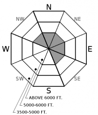
Tuesday | Tuesday Night | Wednesday | |
---|---|---|---|
Cloud Cover: | Light snowfall | Light snowfall | Flurries lingering |
Temperatures: | 22 to 27 deg. F. | 12 to 17 deg. F. | 26 to 31 deg. F. |
Wind Direction: | W | W | SW |
Wind Speed: | 5 to 15 mph | 5 to 15 mph | 0 to 10 mph |
Snowfall: | 1 to 3 in. | 2 to 5 in. | 0 to 1 in. |
Snow Line: |
Whitefish Range
Swan Range
How to read the forecast
The recent snow is most problematic on steep, wind loaded slopes. Be wary of thicker slabs in leeward terrain.
![](/sites/all/themes/responsive_sac/img/advisory-mountain.png)
2. Moderate
?
Above 6500 ft.![](/sites/all/themes/responsive_sac/img/dli/2.png)
1. Low
?
5000-6500 ft.![](/sites/all/themes/responsive_sac/img/dli/1.png)
1. Low
?
3500-5000 ft.![](/sites/all/themes/responsive_sac/img/dli/1.png)
- 1. Low
- 2. Moderate
- 3. Considerable
- 4. High
- 5. Extreme
-
Type ?
-
Aspect/Elevation ?
-
Likelihood ?CertainVery LikelyLikelyPossibleUnlikely
-
Size ?HistoricVery LargeLargeSmall
Gusty southwest winds drifted the foot of recent snow into thicker slabs at higher elevations. Several human triggered and natural wind slabs, up to 2 feet thick, failed during the storm. These are now more stubborn to human triggers. Lingering instabilities are most likely to be found below corniced ridgelines or in cross-loaded terrain features. New snow and wind today could form shallow but more sensitive drifts. Avoid these problems by steering away from thicker, denser pillows of snow. Shooting cracks, collapses, and blowing snow are signs of instability.
Sunday's storm brought up to 13" of new snow and gusty southwest winds. Backcountry travelers triggered numerous thin storm slabs and larger wind slabs during the peak of the storm (observation). These slides failed on low density precipitation layers that are generally quick to heal. Yesterday, observers in the Northern Whitefish Range and Apgar Range found mending storm slab issues but noted cracking and propagating test results in wind drifted slopes. Now 36 hours out from the brunt of the storm, we are trending the danger down and dropped storm slabs off the list. In wind sheltered terrain, the snowpack is generally safe, but watch for isolated exceptions and shallow sluffing.
Today's new snow and increased wind speeds should be benign, except for shallow sluffing or small pockets of drifted snow. If today's weather surprises us with more than 6" of new snow, expect more widespread or hazardous new snow instabilities.
Northwest flow will bring light snowfall to the mountains today. We should see 2" to 4" of new snow, with a few favored pockets wringing out half a foot. Moderate westerly winds accompany this system. Snowfall continues tonight, favoring the Swan Range and fizzles out tomorrow.
This advisory applies only to backcountry areas outside established ski area boundaries. This advisory describes general avalanche conditions and local variations always occur. This advisory expires at midnight on the posted day unless otherwise noted. The information in this advisory is provided by the USDA Forest Service who is solely responsible for its content.