| Monday | Monday Night | Tuesday | |
|---|---|---|---|
| Cloud Cover: | Cold temperatures with decreasing winds | COLD! | Slightly warmer with calm winds |
| Temperatures: | 5 to 10 deg. F. | -15 to -10 deg. F. | 10 to 15 deg. F. |
| Wind Direction: | NE | NE | SW |
| Wind Speed: | 5 to 10 mph, gusting to 20 mph | 1 to 11 mph | 1 to 11 mph |
| Snowfall: | 0 in. | 0 in. | 0 in. |
| Snow Line: |
Whitefish Range
Swan Range
Flathead Range and Glacier National Park
How to read the forecast
The blizzard ended leaving thick wind slabs on atypical aspects. Storm slabs exist at all elevations but are becoming stubborn to trigger. The avalanche danger is trending down but it remains important to carefully assess recent wind slabs and storm slabs before committing to a slope.

3. Considerable
?
Above 6500 ft.
2. Moderate
?
5000-6500 ft.
2. Moderate
?
3500-5000 ft.
- 1. Low
- 2. Moderate
- 3. Considerable
- 4. High
- 5. Extreme
-
Type ?
-
Aspect/Elevation ?
-
Likelihood ?CertainVery LikelyLikelyPossible
 Unlikely
 -
Size ?HistoricVery LargeLargeSmall

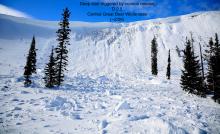
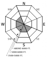
36 hours of the north through east winds formed wind slabs several feet thick on atypical aspects. Slabs formed on low-density snow which may produce collapsing (observation). Slabs also formed on scoured surfaces which will act as a slick bed surface. Look for drifts and pillows of snow below ridgelines and in gullies. At mid-elevations cross-loaded features may harbor fresh slabs. Surface cracking, hollow sounds, and whumpfing are all signs of instability. The safest and most enjoyable areas to recreate will be in sheltered locations.
-
Type ?
-
Aspect/Elevation ?
-
Likelihood ?CertainVery LikelyLikelyPossible
 Unlikely
 -
Size ?HistoricVery LargeLargeSmall

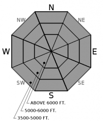
At low and mid elevations a natural avalanche cycle occurred Wednesday night with storm slabs sliding on an underlying rain crust capped with a thin layer of facets (video). Recent snowfall ended Saturday evening depositing up to 22" of snow at all elevations. Observations have been limited but we assume another avalanche cycle occurred during this storm. Storm slabs are becoming more stubborn to trigger but resulting slides will be 2-3" thick and entrain substantial snow. Slabs will be deeper below ridgelines and in gulleys. Low-density snow found in the trees is great until it isn't. Don't be lulled into complacency at low and mid elevations.
-
Type ?
-
Aspect/Elevation ?
-
Likelihood ?CertainVery LikelyLikelyPossible
 Unlikely
 -
Size ?HistoricVery LargeLargeSmall

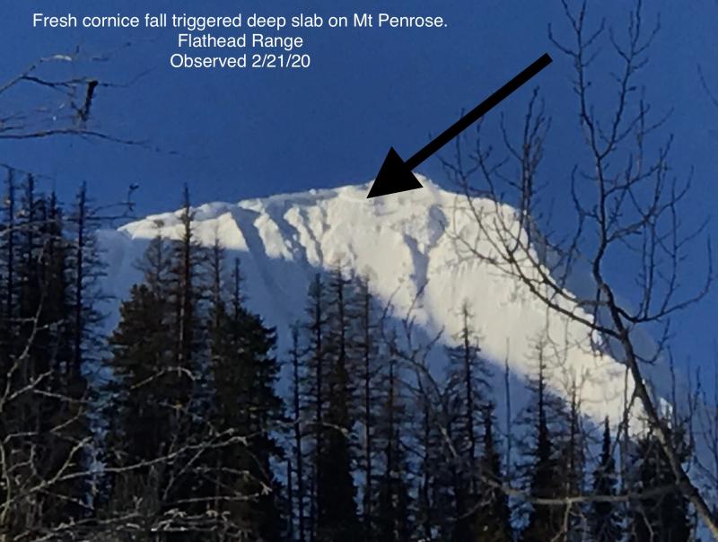
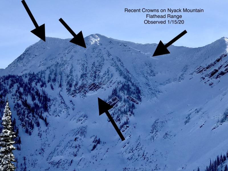
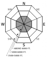
Due to limited observations, we don't know if our recent storm affected the crust/weak snow combo near the ground. Deep slab avalanche activity has been associated with every heavy loading event this season and produced several deep, hard slab avalanches within the past 2 weeks (observation 1, observation 2, observation3). The terrain where these slides occur is steep upper elevations where the slab is not of uniform thickness due to rock outcrops. Terrain management entails well-supported slopes with a deep and uniform snow cover.
Unfortunately, the north through east winds continued overnight exacerbating our wind slab problem. Observations from WMR snow safety yesterday morning reported wind transport that has not been seen in quite some time. BNSF snow safety reported numerous impressive wind features throughout John F. Stevens Canyon. Prior to the wind event 2-3' of low-density snow rested on the surface. Expect the unexpected with a blizzard like this with unique loading patterns and avalanche concerns.
Limited precipitation occurred over the past 24 hours allowing our storm slab to gain a bit of strength. This slab is resting on a rain crust capped with facets at low and mid elevations. In sheltered areas expect to find low-density snow with good riding conditions but stay on guard for changes in the texture of the surface snow. With a great sliding surface capped by a weak layer, even very soft slabs could be reactive, run far and entrain substantial snow.
To find out more about our deep slab problem, please visit our forecaster’s corner blog post: http://www.flatheadavalanche.org/forecast-corner
Cold arctic air has settled into our region producing very cold temperatures this morning. Fortunately, winds will decrease through the day with wind chill advisories expiring by 1 p.m. Some of the seasons coldest temperatures are expected tonight into tomorrow morning. Slightly warmer temperatures are on tap for tomorrow with calm winds. Dry air with no precipitation is expected either day.
This advisory applies only to backcountry areas outside established ski area boundaries. This advisory describes general avalanche conditions and local variations always occur. This advisory expires at midnight on the posted day unless otherwise noted. The information in this advisory is provided by the USDA Forest Service who is solely responsible for its content.


