| Wednesday | Wednesday Night | Thursday | |
|---|---|---|---|
| Cloud Cover: | Snow showers | Snow showers | Snow showers |
| Temperatures: | deg. F. | deg. F. | deg. F. |
| Wind Direction: | West | West | West |
| Wind Speed: | 0 to 10 mph | 0 to 10 mph | 0 to 10 mph |
| Snowfall: | 1 to 3 in. | 1 to 3 in. | 1 to 2 in. |
| Snow Line: |
Swan Range
How to read the forecast
The snowpack continues to gradually stabilize following last week's storm and avalanche cycle. Heightened avalanche conditions exist at upper elevations, where recent wind loading overlaps with stubborn but consequential persistent slab concerns.

2. Moderate
?
Above 6500 ft.
1. Low
?
5000-6500 ft.
1. Low
?
3500-5000 ft.
- 1. Low
- 2. Moderate
- 3. Considerable
- 4. High
- 5. Extreme
-
Type ?
-
Aspect/Elevation ?

-
Likelihood ?CertainVery LikelyLikelyPossible
 Unlikely
 -
Size ?HistoricVery LargeLargeSmall

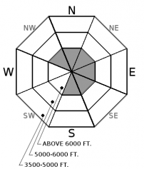
Yesterday's wind event left shallow but dense drifts of snow on leeward and cross-loaded slopes at upper elevations. These stiff wind slabs are the type that don't give great feedback but could break above you and take you for an unpleasant ride. Give them another day or two to heal. Avoid consequential slopes with smooth, rounded texture or hard, hollow-sounding snow.
-
Type ?
-
Aspect/Elevation ?

-
Likelihood ?CertainVery LikelyLikelyPossible
 Unlikely
 -
Size ?HistoricVery LargeLargeSmall

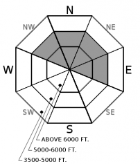
A few slopes harbor surface hoar or faceted crusts 2 to 4 feet deep. Several destructive avalanches that ran last week in the Flathead Range exemplify the problem. We have found propagating test results on buried weak layers in all 3 ranges, but the distribution is spotty and feedback has been scarce. Persistent slabs are becoming isolated and harder to trigger as the snowpack settles. You can reduce your risk by avoiding steep, open convexities and opting for well-supported terrain.
Observers in Southern GNP and Flathead Range noted large plumes and active wind loading at higher elevations yesterday, where there is still some dry snow available for transport. WMR Ski patrol reported stiff but stubborn wind slabs from explosive mitigation after Monday night's wind event. The wind slab problem appears to be shallow but the type you don't want to tangle with in bigger terrain. If you are traveling at higher elevations, pay close attention to the snow surface texture and avoid lenses of hard wind slab. The riding quality will be better away from the wind slabs anyway.
We've lowered the likelihood of persistent slabs today now that the major loading event and warmup are over. Fortunately, this is becoming an isolated concern, but unfortunately, the consequences remain severe if you find the wrong slope. Digging down 3 or 4 feet to look for surface hoar or faceted crusts is a wise choice before heading into more complex terrain.
Keep an eye on snow accumulations today. If snow totals exceed our forecasted numbers, we could have fresh storm instabilities to deal with as well.
Cool, northwest flow will bring snow showers and light to moderate winds for the next two days. A warmer and wetter system arrives on Friday. Look for several bands of snow showers today favoring the Swan Range with up to 5" by tonight. Temperatures should remain parked in the 20s.
This advisory applies only to backcountry areas outside established ski area boundaries. This advisory describes general avalanche conditions and local variations always occur. This advisory expires at midnight on the posted day unless otherwise noted. The information in this advisory is provided by the USDA Forest Service who is solely responsible for its content.


