| Wednesday | Wednesday Night | Thursday | |
|---|---|---|---|
| Cloud Cover: | Increased clouds and wind | Snow/rain mix starting | Mix of rain and snow |
| Temperatures: | 32 to 37 deg. F. | 29 to 34 deg. F. | 32 to 37 deg. F. |
| Wind Direction: | SW | SW | SW |
| Wind Speed: | 5 to 15, G30 | 5 to 15, G30 | 10 to 20, G40 |
| Snowfall: | 0 in. | 0 in. | 1 to 3 in. |
| Snow Line: |
Whitefish Range
How to read the forecast
The avalanche danger is gradually trending down following a significant storm and noteworthy deep slab avalanche cycle. Buried weak layers are slow to adjust though; a very destructive deep slab released naturally in the vicinity of Monday night. Heightened avalanche conditions warrant careful terrain selection and snowpack assessments; expect the danger to rise again tomorrow.

2. Moderate
?
Above 6500 ft.
2. Moderate
?
5000-6500 ft.
1. Low
?
3500-5000 ft.
- 1. Low
- 2. Moderate
- 3. Considerable
- 4. High
- 5. Extreme
-
Type ?
-
Aspect/Elevation ?
-
Likelihood ?CertainVery LikelyLikelyPossible
 Unlikely
 -
Size ?HistoricVery LargeLargeSmall

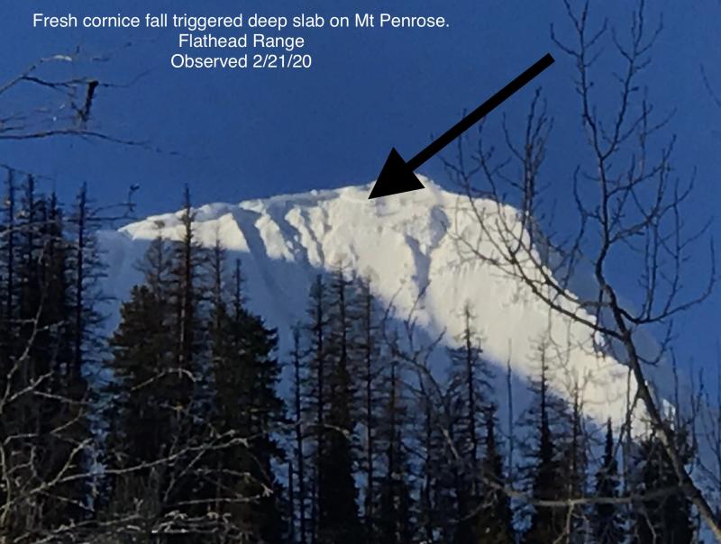
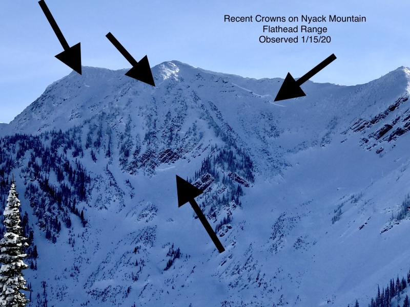
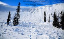
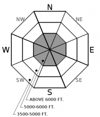
Deep slabs breaking on weak facets near the ground remain a high consequence concern in the Whitefish Range. Last week's storm reactivated deep weak layers and we observed several hard slab avalanches that broke up to 4+ feet deep and ran long distances, and one ran as recently as Monday night in the Flathead Range. Deep slabs are most likely to be triggered on upper elevation slopes with variable and thin snow coverage, especially around rocky terrain. Snowpack assessments for deep weak layers are challenging; careful terrain selection is your best weapon.
-
Type ?
-
Aspect/Elevation ?

-
Likelihood ?CertainVery LikelyLikelyPossible
 Unlikely
 -
Size ?HistoricVery LargeLargeSmall

Last week's storm favored the Southern Ranges and formed 1 to 2 foot soft slabs at mid to upper elevations. These slabs could be sensitive to human triggers on slopes where the slabs buried surface hoar layers (see video) or thin, faceted rain crusts (see observation). Shooting cracks or collapses are warning signs, but assess the snowpack on each slope to identify weak layers. Opt for less consequential terrain or lower angled slopes if in doubt.
-
Type ?
-
Aspect/Elevation ?
-
Likelihood ?CertainVery LikelyLikelyPossible
 Unlikely
 -
Size ?HistoricVery LargeLargeSmall

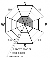
Winds increased overnight, gusting into the 40's and 50's out of the southwest. There is still dry snow available for transport on northerly aspects, so watch for freshly forming wind slabs in shaded basins where the winds are swirling around or crossloading slopes. Avoid consequential rollovers or gullies if you see evidence of drifting snow.
Let's compare today's avalanche conditions to a high stakes poker game. Conditions are slowly improving, and the odds are in your favor that you'll take the hand. But with deep slab problems, you are betting the house, the car, the wife, the kids, and the dog. There is zero room for error, so the best strategy is to choose your terrain carefully. We have a growing gallery of recent deep slab avalanches on our observervation page, and there is a pattern to the type of terrain that these are failing on. So you can hedge your bets by steering clear of that type of terrain for now. That leaves plenty of other terrain options to choose from today. But with our newly formed persistent slabs (buried surface hoar/ rain crust), you don't want to go all in just yet. Watch the hand unfold by digging into the snow numerous times to see if those layers are present and reactive where you are traveling, and stay observant for signs of instability. There is a lot of terrain where you can recreate safely today, but there are some slopes that can end the game abruptly. Stay alert out there.
Southwest winds are increasing ahead of the next system which looks to arrive under southwest flow tonight. Mountain temperatures are in the 20's this morning, but will gradually rise over the next 24 hours, with the freezing level reaching to around 5,500 feet. Snowfall kicks off tomorrow, and a cold front on Thursday evening will amplify snowfall and lower the freezing level.
This advisory applies only to backcountry areas outside established ski area boundaries. This advisory describes general avalanche conditions and local variations always occur. This advisory expires at midnight on the posted day unless otherwise noted. The information in this advisory is provided by the USDA Forest Service who is solely responsible for its content.


