| Tuesday | Tuesday Night | Wednesday | |
|---|---|---|---|
| Cloud Cover: | Valley fog burning off through the day | Snow flurries | Mostly cloudy and breezy |
| Temperatures: | 34 to 39 deg. F. | 18 to 23 deg. F. | 30 to 35 deg. F. |
| Wind Direction: | SW | SW | SW |
| Wind Speed: | 0 to 10 | 5 to 15 | 5 to 15, gusting to 30 |
| Snowfall: | 0 in. | 0 to 2 in. | 0 in. |
| Snow Line: |
Swan Range
How to read the forecast
Stability is improving, but a complicated snowpack with potential for suprising buried weak layers makes for heightened avalanche conditions today. Carefully assess the snowpack before venturing into steeper terrain above 5,000 ft.

2. Moderate
?
Above 6500 ft.
2. Moderate
?
5000-6500 ft.
1. Low
?
3500-5000 ft.
- 1. Low
- 2. Moderate
- 3. Considerable
- 4. High
- 5. Extreme
-
Type ?
-
Aspect/Elevation ?

-
Likelihood ?CertainVery LikelyLikelyPossible
 Unlikely
 -
Size ?HistoricVery LargeLargeSmall

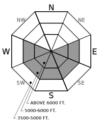
Last week's storm favored the Southern Ranges and formed 2 to 3 foot soft slabs at mid to upper elevations. These slabs remain sensitive to human triggers on some slopes where the slabs buried surface hoar layers (see video) or thin, faceted rain crusts (see observation). Shooting cracks or collapses are warning signs, but you need to assess the snowpack on a slope by slope basis to handle the potential for lurking weak layers. Opt for smaller, less consequential terrain or lower angled slopes if in doubt.
-
Type ?
-
Aspect/Elevation ?

-
Likelihood ?CertainVery LikelyLikelyPossible
 Unlikely
 -
Size ?HistoricVery LargeLargeSmall

Yesterday's sunny warmup produced wet loose avalanches on steep, sunny slopes. These slides are generally small, but could be large enough to bury you in a terrain trap or long running terrain, and they can act as triggers for larger avalanche problems. Monitor for changing conditions through the day by observing how wet the snow surface is and being wary of sunnier, warmer slopes above you. Rollerballs and pinwheels are indicators of changing conditions.
This snowpack is the type that I lose sleep over. Stability is generally improving and the weather is empowering, but there are some slopes today capable of producing a deadly avalanche, and they won't be blatantly obvious. Read on...
There are two potential weak interfaces in our snowpack. The most prominent is the December 15th facet layer/Thanksgiving Crust, which lurks at the bottom of our snowpack. At upper elevations, this layer is roughly 6 feet deep in the Swan Range, 5 feet deep in the Middle Fork, 4 feet deep in Southern GNP and Southern Whitefish Range, and 3 feet deep in the Northern Whitefish Range. This layer is weaker and more susceptible to human triggers in geographic areas where the snowpack is shallower and on specific slopes where the snowdepths are variable and rockier (See this video). We have transitioned this problem over to deep slab travel advice, with a higher likelihood in the Whitefish Range.
The other layer(s) of concern is the buried surface hoar and faceted rain crust layers below our most recent storm snow. These layers are generally buried 1 to 2 feet in the Whitefish Range and 2 to 3 feet in the Swan and Flathead Ranges; ideal depths for human triggering. The surface hoar layer has been spotty in distribution, but observers recently noted propagating test results on buried surface hoar near Skyland, in the Middle Fork, and Whitefish Range. We have limited data on the Swan Range. The rain crust is fairly widespread up to 6,000 feet, but we have only found it paired with facets and a substantial slab in a few places so far. We have been describing these problems as a storm slab up until now, but the travel advice is changing towards persisent slabs as these slabs settle and non-persistent weak layers heal up. Lingering instabilities are becoming specific to those slopes holding a thick enough slab over a persistent facet or surface hoar layer. Persistent slabs have more erratic/unpredictable behavior, require more digging on your part, and require avoidance of suspect steeper terrain when in doubt. Surface hoar is especially worrisome and commonly catches people off guard becuase of how variable it can be from slope to slope or basin to basin. We are still gathering data on how widespread and where in the terrain this problem is most concerning, but anticipate a changing snowpack as you cross through different elevation bands or move from wind sheltered to wind protected terrain. Keep your eyes open for shooting cracks and ears tuned in for collapses, and let us know what you find so we can build a more accurate picture.
A weak disturbance will move across our high pressure ridge later today and tonight, causing an increase in upper level clouds this afternoon and some snow showers tonight. Temperatures will rise from the 20s this morning to near or above freezing, with valley fog slowly burning off through the day. Wednesday looks dry, but winds pick up tomorrow in advance of a more potent snow producer that moves in later this week.
This advisory applies only to backcountry areas outside established ski area boundaries. This advisory describes general avalanche conditions and local variations always occur. This advisory expires at midnight on the posted day unless otherwise noted. The information in this advisory is provided by the USDA Forest Service who is solely responsible for its content.


