| Wednesday | Wednesday Night | Thursday | |
|---|---|---|---|
| Cloud Cover: | Cooling temps and moderate snowfall | Light snowfall | Heavy Snowfall |
| Temperatures: | 18 to 23 West, 0 to 5 East deg. F. | 12 to 17 deg. F. | 25 to 30 deg. F. |
| Wind Direction: | W | SW | W |
| Wind Speed: | 0 to 10, Gusting to 20 | 0 to 10 | 0 to 10, Gusting to 20 |
| Snowfall: | 3 to 5 in. | 1 to 3 in. | 6 to 9 in. |
| Snow Line: |
Whitefish Range
Flathead Range and Glacier National Park
How to read the forecast
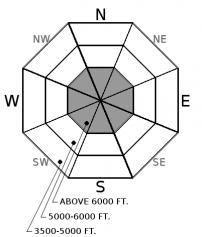
Continued snowfall at higher elevations is making for dangerous avalanche conditions. Storm slabs will be sensitive to human triggers on slopes steeper than 35 degrees, and persistent weak layers near the bottom of the snowpack are being tested by this warming and loading event. You can find improving stability at lower elevations while being wary of the threat of natural releases from above.

3. Considerable
?
Above 6500 ft.
2. Moderate
?
5000-6500 ft.
2. Moderate
?
3500-5000 ft.
- 1. Low
- 2. Moderate
- 3. Considerable
- 4. High
- 5. Extreme
-
Type ?
-
Aspect/Elevation ?

-
Likelihood ?CertainVery LikelyLikelyPossible
 Unlikely
 -
Size ?HistoricVery LargeLargeSmall

In the past 24 hours, up to a foot of dense snow has accumulated at higher elevations (up to 1.8" of SWE), and we will see continued snowfall today. This new snow, along with gusty winds, has formed soft slabs that will be sensitive to human triggers, like this skier triggered avalanche yesterday. Storm slabs are largest and most widespread above 6,000 feet. As you gain elevation, look for cracking snow, drifted snow, or cohesive slabs overlying crusts or low density layers to clue you into the problem. Be especially cautious around terrain traps, steep rollovers, or windloaded slopes.
-
Type ?
-
Aspect/Elevation ?

-
Likelihood ?CertainVery LikelyLikelyPossible
 Unlikely
 -
Size ?HistoricVery LargeLargeSmall

Dense persistent slabs remain a concern on some slopes. Our active warming/wet weather continues to stress the facets or faceted crusts that are now 2 to 4 feet deep in the Whitefish and Flathead Range. These weak layers have been most reactive in areas where the snow depth is shallower (generally less than 4 feet deep). This video is a great example of the problem. The best way to handle the potential for triggering a large and destructive avalanche problem is conservative terrain choices. Default to simpler terrain and avoid steep rollovers if you have uncertainty about the snowpack structure.
Yesterday's rain event reached as high as 5,500 to 6,000 feet yesterday, which may have spoiled the snow surface but has also reduced the distribution of storm slabs to mostly higher elevations. Temperatures finally started dropping the last few hours of dawn, so any new snow that accumulates today at lower elevations will be coming in on top of a refreezing crust. Monitor how much snow is above that crust and how well it is bonding at the mid and lower elevations. Once you climb above that rain crust, it is a whole different ball game. Snow totals will be significantly deeper and storm slabs will be more reactive. 24 hour snow totals at our higher elevation stations range from 11" (1.5" SWE) at Flattop to 9" (1.8" SWE) at Noisy Basin to 1.4" of SWE at Stahl Peak. Observers in the Flattop Range noted significant wind loading yesterday, and wind speeds have been gusting into the 30's at some stations. Storm slabs could break within this new snow or on a variety of crusts or low density layers that were buried earlier this week.
Although we have yet to find local evidence of our persistent slab structure "waking up" during this loading and warming event, it is worth noting that the mountains around Fernie, just north of our advisory area, saw a widespread D3 cycle yesterday on their mid December dry spell layers. Our Canadian neighbors have been dealing with thinner and more reactive persistent slabs recently, but we also know that poor structures exist in our forecast area. I'd be especially nervous about this problem in the Northern Whitefish Range which has held the shallowest snowpack structure this season, or anywhere that the snowpack is less than 4 feet deep. Under our current loading pattern, allow for a large margin of error in your stability assessments for this larger and less predictable problem.
An arctic airmass is slowly advancing eastward over the Continental Divide this morning, while moisture continues to stream in from the Pacific, making for a complicated picture of current and forecasted conditions. Near John F Stevens Canyon, valley winds are gusting up to 40 mph out of the east and temperatures are near 0F. Elsewhere, mountain temperatures are in the mid 20's up high and low 30's down low, and will continue with a cooling trend, the significance of which will be dictated by the cold frontal boundary. Snowfall continues under light to moderate winds today, and ramps up again tomorrow as another subtropical moisture blast makes landfall on Montana.
This advisory applies only to backcountry areas outside established ski area boundaries. This advisory describes general avalanche conditions and local variations always occur. This advisory expires at midnight on the posted day unless otherwise noted. The information in this advisory is provided by the USDA Forest Service who is solely responsible for its content.


