| Sunday | Sunday Night | Monday | |
|---|---|---|---|
| Cloud Cover: | Light snow and windy | Light snow and breezy conditions | Clearing |
| Temperatures: | 29 to 34 deg. F. | 23 to 28 deg. F. | 31 to 36 deg. F. |
| Wind Direction: | Southwest | Southwest | Southwest |
| Wind Speed: | 5 to 15 with gusts to 25 | 5 to 15 with gusts to 25 | 1 to 11 |
| Snowfall: | 0 to 2 in. | 0 to 1 in. | 0 in. |
| Snow Line: |
Whitefish Range
Flathead Range and Glacier National Park
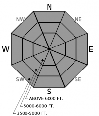
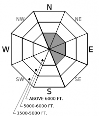
How to read the forecast
The current warming trend is consolidating the surface snow into a slab that is susceptible to human triggering in locations with a poor snowpack structure resulting in a very large destructive avalanche. Recent and current winds have formed thin slabs on leeward aspects at upper elevations. Continue to practice safe travel techniques, recognize bulls eye data such as cracking and collapsing and evaluate the snowpack before committing to a steep slope.

2. Moderate
?
Above 6500 ft.
2. Moderate
?
5000-6500 ft.
2. Moderate
?
3500-5000 ft.
- 1. Low
- 2. Moderate
- 3. Considerable
- 4. High
- 5. Extreme
-
Type ?
-
Aspect/Elevation ?

-
Likelihood ?CertainVery LikelyLikelyPossible
 Unlikely
 -
Size ?HistoricVery LargeLargeSmall

The weather system affecting our area this weekend has warmed the snowpack at all elevations and consolidated the surface snow into more of a slab than what we had just a couple days ago. This slab is 2-4' thick in the Whitefish Range, the Flathead Range along with southern Glacier Park. Observations confirm that weak faceted snow beneath this slab exists at some locations producing a poor snowpack structure. Where this slab is thinnest is where you and/or your machine have the best chance of triggering a very large destructive slide. Our persistent slab problem is spatially variable, and digging is the best way to identify or test for poor structure. It is best to default to lower angle terrain, well anchored terrain and areas free of convexities (rollovers) to manage this problem.
-
Type ?
-
Aspect/Elevation ?

-
Likelihood ?CertainVery LikelyLikelyPossible
 Unlikely
 -
Size ?HistoricVery LargeLargeSmall

Despite rain in the valley floor, snow at upper elevations is still dry enough to be transported. Light to moderate southwest winds yesterday and overnight formed thin wind slabs on a variety of surfaces including new snow, a freezing rain crust, sun crusts from earlier in the week and recently formed faceted snow. Yesterday, cracking and collapsing were associated with fresh wind slabs in southern Glacier Park providing bulls eye data of instability. Look for these thin slabs on leeward sides of ridges and crossloaded terrain features and evaluate the surface snowpack before committing to a wind loaded slope.
Holy warm up! Most valley floor weather stations are slightly above freezing and several upper elevation stations hovering around the freezing mark. Precipitation associated with yesterdays "storm" was light and only deposited 2-3" of snow at upper elevations. Flattop picked up 0.8" of precipitation but only 1" of snow. Observations were limited yesterday but observers in the southern Whitefish Range noted little rain and limited loose snow slides at low elevations with similar conditions in the northern Swan Range. The Middle Fork corridor was a different story with more rain and higher freezing levels leading to a wet loose cycle at low elevations. With continued warming today, low and mid elevation areas not affected by yesterdays warm up may become moist leading to rollerball/pinwheel development and potentially small wet loose slides. Associated loose slides will be small but could be troublesome if you are above a terrain trap or cliff band.
The persistent slab problem is not something we deal with on an annual basis in Northwest Montana and complacency to this problem is something we all need to fight. The partial burial of a snowmobiler in the usually strong snowpack of the Whitefish Range should be a good wake up call to all (see observation). There were two avalanche fatalities this week from northern Wyoming (article) and Southwestern Montana (article) where this is a more common problem. The recent avalanche outside of Fenie, BC that injured several skiers (article) is a good reminder of how unpredictable our current snowpack is.
A warm disturbance remains with us today with light precipitation and windy conditions. Cold pools of air in valley bottoms have been scoured out resulting in relatively warm air at all elevations. Light precipitation overnight in the form of rain in the valley floors and snow at upper elevations. A short lived high pressure will build later today before another system impacts our area on Tuesday.
This advisory applies only to backcountry areas outside established ski area boundaries. This advisory describes general avalanche conditions and local variations always occur. This advisory expires at midnight on the posted day unless otherwise noted. The information in this advisory is provided by the USDA Forest Service who is solely responsible for its content.


