| Friday | Friday Night | Saturday | |
|---|---|---|---|
| Cloud Cover: | Snow. | Heavy snow, wind, and cold temps. | Snow gradually tapering during the day. |
| Temperatures: | 8 to 13 deg. F. | -10 to -5 deg. F. | 15 to 20 deg. F. |
| Wind Direction: | E | E | NW |
| Wind Speed: | 5 to 15 mph with gusts of 30 mph | 10 to 20 mph with gusts of 35 mph | 10 to 15 mph with gusts of 30 mph |
| Snowfall: | 3 to 6 in. | 6 to 9 in. | 3 to 5 in. |
| Snow Line: |
Whitefish Range
How to read the forecast
Heavy snowfall and gusty winds have teamed up to create dangerous avalanche conditions and the avalanche danger is CONSIDERABLE. Storm instabilities will be easily triggered and could fail naturally, and very destructive persistent slab avalanches have potential to fail and run full track. Today is a great day to default to conservative, low angle terrain to manage for storm slabs and lurking deeper instabilities. Give yourself a wide buffer in decision making and route selection.

3. Considerable
?
Above 6500 ft.
3. Considerable
?
5000-6500 ft.
3. Considerable
?
3500-5000 ft.
- 1. Low
- 2. Moderate
- 3. Considerable
- 4. High
- 5. Extreme
-
Type ?
-
Aspect/Elevation ?

-
Likelihood ?CertainVery LikelyLikelyPossible
 Unlikely
 -
Size ?HistoricVery LargeLargeSmall

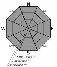
Over a foot of new snow (up to 1.1" of SWE) in the past 48 hours has formed storm slabs on all aspects and elevations that will be easily triggered or could fail naturally. These are largest and most dangerous on higher elevation, windloaded slopes. Touchy storm slabs were observed yesterday (see video) and will be large enough to bury or kill you today. Cracking under your feet or fresh avalanche activity are signs to avoid steep terrain, especially over terrain traps such as trees and gullies.
-
Type ?
-
Aspect/Elevation ?

-
Likelihood ?CertainVery LikelyLikelyPossible
 Unlikely
 -
Size ?HistoricVery LargeLargeSmall

Significant storm totals are adding stress to persistent slabs up 3 to 6 feet thick, overly weak, faceted snow. Natural and human-triggered persistent slabs may become reactive today from substantial loading onto a poor snowpack structure. Avalanches of this size could run full track; we recommend reducing your exposure to overhead hazards.
Once again, we find ourselves in the midst of a major winter storm. Storm totals over the last 24 hours: 10"/ 0.5" snow water equivalent (SWE) in Southern Whitefish Range and 1.1" of SWE at Stahl Peak in the Northern Whitefish Range. The last 2 days of snowfall has buried low density snow, surface hoar layers, and near surface facets. Observations of shooting cracks near the ski resort boundary yesterday indicate that storm slabs will be sensitive, and overnight, they have grown significantly in size.
Rapid loading is adding additional stress to a poor snowpack structure with weak, faceted snow now buried 3 to 5 feet deep. This persistent slab problem is becoming more complex with additional loading and adding to uncertainty about its spatial distribution. We had a major natural avalanche cycle throughout our forecast area ending on 12/20 that flushed some but not all of our buried weak layers. Stability test have shown a strengthening snowpack on some slopes while others are still producing propagating results. During a loading event like this and uncertainty surrounding larger, deeper avalanche problems, its best to notch back your terrain choices to more conservative terrain until the dust settles.
Arctic cold front moved through the Flathead Valley overnight, surface flow has shifted to the East, and we can anticipate gusty winds to develop during the day on Friday. Temperatures steadily dropped behind frontal passage with coldest readings being observed in the John F. Stevens Canyon. For today, dump truck of Pacific moisture will continue to move into northwest Montana with a lull in snowfall expected this afternoon before enhancing overnight. Intense snowfall is expected Friday night into Saturday as trough and associated low pressure begin to move inland and transition over northwest Montana. Expect gradually tapering snowfall for Saturday as northwest flow sets up with continued off and on light snow through Sunday.
This advisory applies only to backcountry areas outside established ski area boundaries. This advisory describes general avalanche conditions and local variations always occur. This advisory expires at midnight on the posted day unless otherwise noted. The information in this advisory is provided by the USDA Forest Service who is solely responsible for its content.


