| Saturday | Saturday Night | Sunday | |
|---|---|---|---|
| Cloud Cover: | Clear and cold. | Clear and cold. | Clear and cold. |
| Temperatures: | 5 to 10 deg. F. | -10 to -5 deg. F. | 5 to 10 deg. F. |
| Wind Direction: | West | Southwest | West |
| Wind Speed: | 0 to 10 mph with gusts to 20 | 5 to 15 mph | 0 to 10 mph |
| Snowfall: | 0 in. | 0 in. | 0 in. |
| Snow Line: |
Whitefish Range
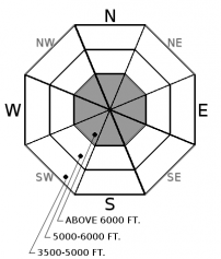
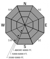
How to read the forecast
Storms over the past week have deposited substantial snow onto a weak fragile snowpack creating dangerous avalanche conditions. Large and destructive human triggered slab avalanches are a serious concern on slopes greater than 30 degrees. Fresh windslabs have returned and have the potential of triggering larger persistent slabs.

3. Considerable
?
Above 6500 ft.
2. Moderate
?
5000-6500 ft.
2. Moderate
?
3500-5000 ft.
- 1. Low
- 2. Moderate
- 3. Considerable
- 4. High
- 5. Extreme
-
Type ?
-
Aspect/Elevation ?

-
Likelihood ?CertainVery LikelyLikelyPossible
 Unlikely
 -
Size ?HistoricVery LargeLargeSmall

Atypical easterly winds yesterday and overnight redistributed 6-11” of low density snow onto leeward and crossloaded slopes in wind loaded slabs. Todays northwesterly winds will form slabs on the other side of the compass. These slabs are forming on weak snow or wind scoured surfaces and will be sensitive to human triggering. A wind slab avalanche has the ability to step down into the snowpack triggering a larger persistent slab. These fresh slabs are easy to detect by the cracking in the snow surface beneath your skis or machine. Look for pillows of snow below ridgelines and in gullies.
-
Type ?
-
Aspect/Elevation ?

-
Likelihood ?CertainVery LikelyLikelyPossible
 Unlikely
 -
Size ?HistoricVery LargeLargeSmall

This weeks bountiful snowfall has formed persistent slabs on all aspects at all elevations throughout our advisory area. Unlike the rest of our forecast area these 2 to 4 foot slabs formed on a freezing rain crust above weak layers such as facets, surface hoar and low density snow in the Whitefish Range. This crust is currently "bridging" the weak layers and triggering these slabs is becoming stubborn but still possible. Current cold weather is prohibiting prohibiting rapid strengthening of the snowpack. Observations throughout the week of triggered slides, collapsing, and shooting cracks are clear evidence that these dangerous slabs should influence your terrain choices. The persistent slab problem can be identified by digging into the snowpack but choosing lower angle less complex terrain is the easiest way to manage this problem.
Relatively dry conditions yesterday and overnight have given our weak snowpack a reprieve from this weeks substantial snowfall. However, the return of cold weather will not help strengthen the weak layers that are now buried under 2 to 4 foot cohesive slabs (photo 1, photo 2). With a slow start to our season of winter recreation this weeks bountiful snowfall appears even more inviting but triggering a large destructive slide remains likely on slopes that haven’t recently avalanched. Wind slabs have returned to our list of problems, and while relatively small in size, they have the ability to trigger a larger persistent slab. We will be dealing with our weak snowpack for the foreseeable future so practicing careful snowpack evaluation, cautious route-finding and conservative decision making is essential. Our current weak snowpack structure is not something we are used to in northwest Montana and requires respect, patience and discipline.
Join us at Stumptown Snowboards in Whitefish on January 3 at 7:00 pm for a free, engaging, and entertaining 1 hour avalanche awareness presentation. Details here.
A cold dry airmass is currently moving into our area bringing some of the coldest temperatures of the season. This morning winds are slowly shifting from yesterday’s east flow to northwesterly and are currently calm to light. Snowfall tapered off yesterday but light snow will return Christmas Eve. Light snow and slightly moderating temperatures can be expected Christmas Day.
This advisory applies only to backcountry areas outside established ski area boundaries. This advisory describes general avalanche conditions and local variations always occur. This advisory expires at midnight on the posted day unless otherwise noted. The information in this advisory is provided by the USDA Forest Service who is solely responsible for its content.


