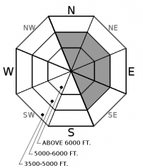
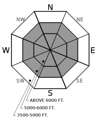
Saturday | Saturday Night | Sunday | |
---|---|---|---|
Cloud Cover: | Cloudy with scattered flurries and light winds. | Partial clearing, cool with calm winds. | Snow and winds increasing throughout the day. |
Temperatures: | 22-27 deg. F. | 15-20 deg. F. | 24-29 deg. F. |
Wind Direction: | West | West | West |
Wind Speed: | 0-10 mph | 0-10 mph | 5-15 with gusts to 25 mph |
Snowfall: | 0-1 in. | 0 in. | 1-2 in. |
Snow Line: |
Whitefish Range
Swan Range
Flathead Range and Glacier National Park
How to read the forecast
The return of snow and wind has increased the avalanche hazard. The avalanche danger is MODERATE above 5000' where wind loaded slabs exist in leeward and crossloaded terrain and relatively dense snow was deposited on weak surface snow in sheltered areas. Human triggered avalanches are possible and may entrain substantial snow and travel long distances. Look for tell tale cracking and collapsing in the surface snow to identify slabs and noting areas with substantial loose snow above a crust.

2. Moderate
?
Above 6500 ft.
2. Moderate
?
5000-6500 ft.
1. Low
?
3500-5000 ft.
- 1. Low
- 2. Moderate
- 3. Considerable
- 4. High
- 5. Extreme
-
Type ?
-
Aspect/Elevation ?
-
Likelihood ?CertainVery LikelyLikelyPossibleUnlikely
-
Size ?HistoricVery LargeLargeSmall
Light snow returned to our area yesterday afternoon accompanied by several hours of moderate winds which formed thin wind loaded slabs on leeward and crossloaded slopes. These slabs were deposited on sun crusts on sunny aspects and wind crusts in exposed areas. Getting caught in even a small slide could have significant consequences due to the thin snowpack and numerous exposed hazards. Slabs can be identified by cracking or collapsing in the snow surface beneath your skis or machine and resemble pillow or lens shaped features below ridgelines and in gullies. Evaluate all wind loaded terrain before committing to a slope.
-
Type ?
-
Aspect/Elevation ?
-
Likelihood ?CertainVery LikelyLikelyPossibleUnlikely
-
Size ?HistoricVery LargeLargeSmall
Yesterday's snow arrived warm and dense and was deposited on a 6-12" layer of low density snow in sheltered locations. Observations from the past week have confirmed that this surface snow is not bonding well to the underlying crust and yesterday's addition of several inches of new snow has increased the hazard of human triggered loose snow slides. These slides will be confined to steep terrain greater than 35º but have the ability to entrain substantial surface snow and travel long distances. Use small test slopes to evaluate the ease of initiating a loose dry avalanche where weak, sugary snow sits on top of a slick rain crust before committing to bigger terrain.
After a two week absence, precipitation returned to our area yesterday afternoon with light snow recorded at all elevations. Several hours of moderate winds formed thin wind slabs which may have a difficult time bonding to the surface crust found at most exposed upper elevation locations. The new dense snow will also increase the loose dry hazard on sheltered steeper terrain where up to 12" of cohesionless, mostly faceted, snow exists. Fortunately/unfortunately this storm is not the heart punch that our weak snow pack is primed for and we will have to wait another couple days before widespread avalanche activity occurs when a warm moist storm arrives Sunday evening. The thick layer of weak surface snow should be a thing of the past if the forecasted storm materializes.
Today is a great day to get out and look at the surface snowpack before the hazard ramps up early this week. It is still early season and there is no better time than now to get into the habit of practicing safe travel techniques while enjoying a little bit of new snow.
Thanks to everyone for submitting observations as this helps us to produce a better product.
A weak system moved into our area yesterday afternoon depositing light snow throughout the advisory area with Noisy Basin, in the Swan Range, favored with 5". Several hours of moderate winds accompanied the arrival of the storm but wind speeds and snowfall diminished early evening. Expect a few scattered flurries today with light winds and temperatures topping out in the low 20's. A relatively warm moist system will move into our area Sunday and will intesify during the evening hours into Monday with a mix of precipitation in the valleys and moderate snow in the mountains.
This advisory applies only to backcountry areas outside established ski area boundaries. This advisory describes general avalanche conditions and local variations always occur. This advisory expires at midnight on the posted day unless otherwise noted. The information in this advisory is provided by the USDA Forest Service who is solely responsible for its content.