


For 5000 ft. to 7000 ft.
| Monday | Monday Night | Tuesday | |
|---|---|---|---|
| Cloud Cover: | Continued cloudy conditions with cool air trapped below the cloud deck | Mostly cloudy with no precipitation and little fluctuation in temperatures. | Continued cloudy conditions with cool air trapped below the cloud deck |
| Temperatures: | 25 to 30 deg. F. | 23 to 28 deg. F. | 25 to 30 deg. F. |
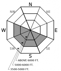
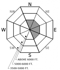
| Wind Direction: | West | West | Southwest |
| Wind Speed: | 1 to 11 mph | 1 to 11 mph | 1 to 11 mph |
| Snowfall: | 0 in. | 0 in. | 0 in. |
| Snow Line: |


