

THIS AVALANCHE FORECAST EXPIRED ON December 2, 2017 @ 8:41 amAvalanche Forecast published on November 29, 2017 @ 8:41 am
Issued by
Chris Bilbrey - Flathead Avalanche Center
Whitefish Range
Swan Range
Flathead Range and Glacier National Park
How to read the forecast
Last night's storm produced new snow with moderate wind speeds and strong gusts. Over the next few days, winds will continue so anticipate wind slab formation to increase in our higher elevation terrain. Wind slabs are more sensitive to human triggering shortly after formation especially in steeper terrain. Wind slabs are now sitting on top of our Thanksgiving rain crust so use small test slopes to assess the depth and sensitivity before committing to slopes steeper than 35 degrees.

No Rating
?
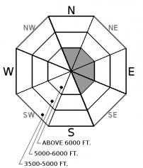
Above 6500 ft.
No Rating
?
5000-6500 ft.
No Rating
?
3500-5000 ft.
Avalanche Problem 1: Wind Slab
-
Type ?

-
Aspect/Elevation ?
-
Likelihood ?CertainVery LikelyLikelyPossible
 Unlikely
 -
Size ?HistoricVery LargeLargeSmall

Newly formed wind slabs in higher elevation terrain are now sitting on top of the Thanksgiving rain crust and will be found on leeward side of ridgelines and favored cross loaded slopes that benefit from a WSW wind flow. Micro terrain features can contribute to quickly changing slab depths so anticipate deeper wind loaded pockets to exist. Pay attention to changing slab depths and distribution as you travel up through mid-elevation terrain into higher elevations. Due to our low and variable snow cover, consider the consequences of triggering even a small wind slab and taking a slide for life on our Thanksgiving rain crust with numerous natural obstacles near the surface.


Forecast discussion
The weather over the last week has been a roller coaster with a mix bag of conditions. The heavy rain event over Thanksgiving that produced over 2" of rainfall and freezing levels around 10,000 feet was followed by colder temps and light snowfall. Last weeks rain event produced numerous loose wet avalanches that gouged the existing snow cover in higher elevation terrain and ran down into mid-elevations. Recent colder temps helped eliminate the potential for loose wet avalanches but also formed a stout rain crust varying from 2 to 8 inches thick depending on elevation and location. This rain crust is a perfect sliding surface for newly formed wind slabs that developed from last nights snowfall accompanied by moderate winds and gust exceeding 25 mph in many higher elevation locations. Wind slabs are more sensitive to human triggering in steeper terrain and shortly after formation and will be found on the leeward side of ridgelines and gully features that benefit from WSW wind flow. Pay attention to changing slab depths and distribution of wind slabs as you travel up through mid-elevation terrain into higher elevations. Evaluate the sensitivity and depth of wind slabs on small test slopes before committing to steeper, bigger terrain. Triggering even a small wind slab and taking a ride could give way to a bad outcome due to our low snow cover and numerous natural hazards.
Our snowpack observations are limited so if your out and about in the mountains, send us your observations. A picture is worth a thousand words so any information can help us improve our product.
Weather and CURRENT CONDITIONS
weather summary
Last night's storm deposited 1-4" throughout our advisory area. Snowfall was accompanied by moderate winds and strong wind gusts. Today expect snowfall to taper throughout the day with a drying trend overnight and into Thursday. Another shot of moisture will arrive Thursday night lasting into Friday. Breezy conditions and seasonable temperatures will continue through this period.
Disclaimer
This advisory applies only to backcountry areas outside established ski area boundaries. This advisory describes general avalanche conditions and local variations always occur. This advisory expires at midnight on the posted day unless otherwise noted. The information in this advisory is provided by the USDA Forest Service who is solely responsible for its content.
Search
Follow or Subscribe


In Partnership With

In Partnership With
