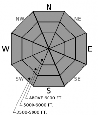
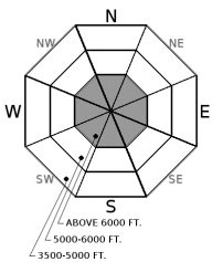
Saturday | Saturday Night | Sunday | |
---|---|---|---|
Cloud Cover: | Partly cloudy and cooler. | Moderate snow. | Snow tapering late. |
Temperatures: | 35-47 deg. F. | 19-30 deg. F. | 30-44 deg. F. |
Wind Direction: | West-southwest | West | West-southwest |
Wind Speed: | 8-10 gusts to 21 | 7-9 | 7-10 |
Snowfall: | 0-1 in. | 4-9 in. | 2-3 in. |
Snow Line: |
Whitefish Range
Swan Range
Flathead Range and Glacier National Park
How to read the forecast
Cool overnight temperatures have formed a thin surface crust at all elevations. This crust will weaken throughout the day as temperatures warm and especially if forecasted precipitation enters our area sooner than expected. At upper elevations there exists a layer of unconsolidated surface snow that is susceptible to triggering a larger wet loose avalanche. The avalanche danger is LOW. Pay attention to changing snow surface and weather conditions today while continuing to practice safe backcountry travel techniques.

1. Low
?
Above 6500 ft.
1. Low
?
5000-6500 ft.
1. Low
?
3500-5000 ft.
- 1. Low
- 2. Moderate
- 3. Considerable
- 4. High
- 5. Extreme
-
Type ?
-
Aspect/Elevation ?
-
Likelihood ?CertainVery LikelyLikelyPossibleUnlikely
-
Size ?HistoricVery LargeLargeSmall
Temperatures dropped below freezing at most locations overnight which has formed a surface crust of variable strength. As temperatures warm throughout the day this crust will break down, particularly at low and mid elevations. These 2 elevation bands have been worked over by recent warm wet weather and triggered wet loose activity will be of small size. At upper elevations there exists a layer of unconsolidated snow, up to 12" thick, resting on a stout crust. The potential for a larger triggered loose wet avalanche remains, especially in areas sheltered from the wind. Keep in mind that the effects of small, loose, wet avalanches can be amplified by terrain traps like narrow gullies, trees, and cliffs.
-
Type ?
-
Aspect/Elevation ?
-
Likelihood ?CertainVery LikelyLikelyPossibleUnlikely
-
Size ?HistoricVery LargeLargeSmall
Cooler temperatures overnight and through today will strengthen the large cornices thoughout our area "a little bit". Due to extended warming a fair amount of cornice fall has occured over the past few weeks, with some of these backcountry bombs triggering wind slab avalanches. Natural cornice fall today will be minimal but these large wind features deserve respect and it is best to give them a wide berth. Be aware that cornices can break farther back on the ridge than you might expect. Avoid traveling on slopes underneath cornices.
Friday: FAC staff traveled to Noisy Basin in the Swan Range where they observed recent wet loose avalanche activity from Tuesday's warm sunny weather along with older cornice debris and one glide crack. At all elevations the surface was moist except on exposed upper elevation windward slopes that harbored a breakable crust. Going to the Sun Road avalanche program noted evidence of wet loose activity from 4/4, several glide cracks along with wet surface conditions.
Thursday: Going to the Sun Avalanche Program toured on Mount Cannon in Glacier National Park. They found generally wet snow conditions and 5 cm of recent, wet snow above 5800 feet. They noted evidence of small, loose, wet avalanche activity likely to have occurred due to warm temperatures on Tuesday (4/4). Skiers east of the advisory in southern Glacier National Park noted above freezing temperatures and variable surface conditions. They observed debris from a recent slab avalanche triggered by cornice fall.
Tuesday: FAC Staff toured the Skookaleel Ridge area in the Southern Whitefish Range. Sunshine was abundant and warming the 1 to 2 inches of new snow above the crust on solar aspects. The surface snow in shaded areas and non-solar aspects was not impacted. The crust at the surface varied considerably in strength and thickness. Stronger and thicker on slopes exposed to the sun and thinner and weaker on non-solar aspects. Skiers on Gunsight Mountain in Glacier National Park (outside the advisory area) reported 1 to 10 inches of new snow from Monday and small but sensitive wind slabs.
See below for all observations this season.
Yesterday was a wild spring weather day with rain, graupel, moderate to strong sustained winds with extreme gusts and a bit of lightning to top it off. Currently, mountain temperatures range from 25-34º F with winds out of the southwest at 7-20 mph. Today should bring partly cloudy skies with temperatures in the low to upper 30s. Precipitation will return to our area tonight into tomorrow with lowering snow levels.
0600 temperature: | 25-34 deg. F. |
Max. temperature in the last 24 hours: | 35-46 deg. F. |
Average wind direction during the last 24 hours: | Southwest |
Average wind speed during the last 24 hours: | 3-36 mph |
Maximum wind gust in the last 24 hours: | 37-55 mph |
New snowfall in the last 24 hours: | 0 inches |
Total snow depth: | 82-121 inches |
This advisory applies only to backcountry areas outside established ski area boundaries. This advisory describes general avalanche conditions and local variations always occur. This advisory expires at midnight on the posted day unless otherwise noted. The information in this advisory is provided by the USDA Forest Service who is solely responsible for its content.