


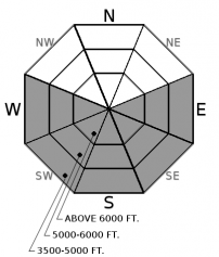


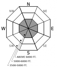


For 5000 ft. to 7000 ft.
| Tuesday | Tuesday Night | Wednesday | |
|---|---|---|---|
| Cloud Cover: | Mostly sunny, warming temperatures | Partly cloudy | Warming but with increasing clouds |
| Temperatures: | 32 to 46 deg. F. | 17 to 27 deg. F. | 37 to 51 deg. F. |
| Wind Direction: | south-southwest | southwest | south-southwest |
| Wind Speed: | 4-5 mph | 5-6 with gusts to 17 mph | 7-10 with gusts to 21 mph |
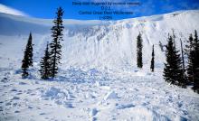
| Snowfall: | 0 in. | 0 in. | 0 in. |
| Snow Line: |


