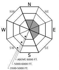
Wednesday | Wednesday Night | Thursday | |
---|---|---|---|
Cloud Cover: | Mostly cloudy with light/moderate rain/snow. | Light snow and cooling. | Light snow. |
Temperatures: | 33-47 deg. F. | 24-34 deg. F. | 34-49 deg. F. |
Wind Direction: | South-Southwest | Southwest | West-Southwest |
Wind Speed: | 10-14 gusts 21-28 | 10-14 gusts 21-28 | 7-8 gusts 20 |
Snowfall: | 0-4 in. | 0-3 in. | 0-2 in. |
Snow Line: |
Whitefish Range
Swan Range
Flathead Range and Glacier National Park
How to read the forecast
Recently formed wind slabs will be slow to strengthen due to the smooth crust (sliding surface) they were formed on. A few inches of snow and continued wind today will thicken these slabs. The avalanche danger is MODERATE above 6000 feet. Carefully evaluate wind loaded terrain before committing to a slope. Below 6000 feet the danger is LOW, but will rise if we get rain to assist in breaking down the surface crust.

2. Moderate
?
Above 6500 ft.
1. Low
?
5000-6500 ft.
1. Low
?
3500-5000 ft.
- 1. Low
- 2. Moderate
- 3. Considerable
- 4. High
- 5. Extreme
-
Type ?
-
Aspect/Elevation ?
-
Likelihood ?CertainVery LikelyLikelyPossibleUnlikely
-
Size ?HistoricVery LargeLargeSmall
Incremental snow and moderate to strong winds over the past few days continue to thicken slabs that were formed on a smooth near surface crust. Expect lingering instability in recent wind slabs that are up to 1.5 feet thick. Carefully evaluate all potentially wind loaded terrain before committing to a slope today. Look for smooth, rounded features on the snow surface and pay attention to obvious signs of instability like cracking and collapsing while traveling along a ridgeline.
-
Type ?
-
Aspect/Elevation ?
-
Likelihood ?CertainVery LikelyLikelyPossibleUnlikely
-
Size ?HistoricVery LargeLargeSmall
With the cool temperatures over the past 24 hours loose, wet avalanches won't be a problem early. There is some uncertainty in the snow level today and the potential for rain at low to mid elevation that can loosen the frozen snow surface pretty quickly. Avoid steep slopes and terrain traps when you notice the surface crust becoming less supportable.
The wet slab cycle we saw in mid-March due to high rain levels was impressive, but I don't think we have seen the last of them. Most of these avalanches occurred in the mid-elevation band. Though we did see some storm slab activity in the high elevations the upper snow pack absorbed most of the free-water before it could pool on deeper crusts. With the fickle and often surprising weather events that Spring in northwest Montana brings it's important to pay attention to conditions that could weaken these deep layers again. Like extended periods of warm and sunny weather and rain that soaks the snow at higher elevations.
Massive cornices exist along many of the ridgelines across the advisory area. Pay attention to changing weather conditions that could weaken these features like warming temperatures, sun exposure, additional wind-loading, and rain. It's important to pay attention to what is suspended above you given the unusual size and how overhung many of these cornices are. Keep a good distance from these while traveling along ridge lines as they can pull out further back than expected, even behind the solid ground. When a large cornice falls it has the potential to trigger deep instabilities that would otherwise remain dormant resulting in a large avalanche.
Glide cracks have also been observed opening up in many locations. The first reported glide avalanche this season was March 25 and occurred west of the WMR ski area in the southern Whitefish Range. There is a large amount of uncertainty associated with glide avalanches, so the best way to manage them is to avoid slopes where they are present.
Monday: Todd and Zach ventured to the Red Meadow area of the northern Whitefish Range. The depth of snow on top of the firm crust varied depending on elevation and apect, but they found up to 8 inches of snow above it at upper elevations. Rollerballs and small loose wet avalanches were easily triggered on top of the crust. We also received a report of a cornice triggered wind slab from outside the advisory area in Glacier National Park near St. Mary.
Sunday: FAC staff toured in the backcountry north of Canyon Creek in the southern Whitefish Range. Prolonged sun weakened the snow surface and allowed for small skier triggered loose wet avalanches on our descent at both upper and mid elevations. At upper elevations a 18" thick crust sat beneath the 2-3" of new snow.
See below for all observations this season.
In the past 24 hours temperatures stayed cool and we picked up 1-3 inches of new snow. Currently, temperatures above 6000 feet range from 24-30º F, and winds are out of the southwest at 6 mph up to 21mph with gusts from 8-35 mph. Today, should see light snow/rain that will increase tonight. Temperatures are expected to climb to the mid-30s, and southwest winds will continue at 5-15 mph with stronger gusts along the ridgelines.
0600 temperature: | 24-30 deg. F. |
Max. temperature in the last 24 hours: | 26-33 deg. F. |
Average wind direction during the last 24 hours: | Southwest |
Average wind speed during the last 24 hours: | 5-15 mph |
Maximum wind gust in the last 24 hours: | 17-45 mph |
New snowfall in the last 24 hours: | 0-3 inches |
Total snow depth: | 87-122 inches |
This advisory applies only to backcountry areas outside established ski area boundaries. This advisory describes general avalanche conditions and local variations always occur. This advisory expires at midnight on the posted day unless otherwise noted. The information in this advisory is provided by the USDA Forest Service who is solely responsible for its content.