| Monday | Monday Night | Tuesday | |
|---|---|---|---|
| Cloud Cover: | Light precipitation with breezy conditions. | Precipitation ending with continued breezy conditions. | Light precipitation enters our area with seasonal temperatures. |
| Temperatures: | 30-47 deg. F. | 18-28 deg. F. | 31-46 deg. F. |
| Wind Direction: | Southwest | West-southwest | Southwest |
| Wind Speed: | 13-14 mph with gusts to 31 | 10-12 mph with gusts to 25 | 7-9 mph with gusts to 21 |
| Snowfall: | 0-3 in. | 0 in. | 0-1 in. |
| Snow Line: |
Whitefish Range
Swan Range
Flathead Range and Glacier National Park
How to read the forecast
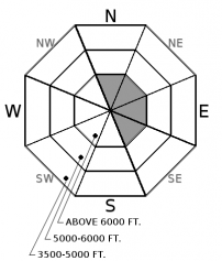
Overnight snow, combined with wind, has formed fresh wind slabs on top of a surface crust. These slabs will continue to form through the day with expected light precipitation and continued wind. Lingering instabilities remain with the wind slabs formed earlier in the weekend. The avalanche danger is MODERATE above 6000' on wind loaded terrain and LOW below 6000' where rain and a moist snow surface have resulted in a loose wet avalanche problem.

2. Moderate
?
Above 6500 ft.
1. Low
?
5000-6500 ft.
1. Low
?
3500-5000 ft.
- 1. Low
- 2. Moderate
- 3. Considerable
- 4. High
- 5. Extreme
-
Type ?
-
Aspect/Elevation ?

-
Likelihood ?CertainVery LikelyLikelyPossible
 Unlikely
 -
Size ?HistoricVery LargeLargeSmall

New snow overnight, combined with breezy conditions, has formed fresh wind slabs on top of a surface crust. These thin wind slabs will cotinue to form through the day today due to expected light precipitation and wind. Wind slabs that formed Friday night through Sunday morning have strengthened a bit but they also were deposited onto a crust and lingering instabilities remain with these. Due to the current southwest winds these slabs will be confined to the typical leeward aspects at upper elevations. Evaluate all wind loaded terrain before committing to a slope today. Wind slabs can be identified by cracking in the snow beneath your skis or machine along with smooth rounded pillows of snow on the leeward sides of ridgelines.
-
Type ?
-
Aspect/Elevation ?

-
Likelihood ?CertainVery LikelyLikelyPossible
 Unlikely
 -
Size ?HistoricVery LargeLargeSmall

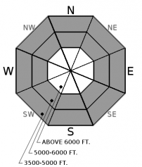
Yesterdays bluebird skies and warm temperatures weakened and moistened the surface snow at all elevations. Cloud cover overnight has not allowed this surface to refreeze at low elevations and probabley left us with a weak refreeze at mid elevations. Precipitation overnight fell as rain at low elevations and a rain/snow mix at mid elevations which has further weakened the surface snow. A tell tale sign of a loose wet avalanche problem is your skis or machine sinking through the surface into the unconsolidated snow beneath.
Giant cornices exist along most ridgelines across the advisory area. It's important to pay attention to what is looming above you given the unusual size and how overhung many of these cornices are. Keep a good distance from these while traveling along ridge lines as they can pull out further back than expected, even behind the solid ground. When a large cornice falls it has the potential to trigger deep instabilities that would otherwise remain dormant resulting in a large avalanche.
Glide cracks have also been observed opening up in many locations. The first reported glide avalanche this season was March 25 and occured west of the WMR ski area in the southern Whitefish Range. There is a large amount of uncertainty associated with glide avalanches, so the best way to manage them is to avoid slopes where they are present.
Sunday: FAC staff toured in the backcountry north of Canyon Creek in the southern Whitefish Range. Prolonged sun weakened the snow surface and allowed for small skier triggered loose wet avalanches on our descent at both upper and mid elevations. At upper elevations a 18" thick crust sat beneath the 2-3" of new snow.
Saturday: FAC staff traveled to Elk Mountain, in southern Glacier Park, where they noted active wind loading throughout the day with fresh wind slab development. Skiers in Marion Lake, in the Flathead Range, were able to intentionally trigger a wind slab avalanche that travelled 2000'. Skiers in the southern Whitefish Range observed small wind slabs that were reactive to skis and noted a glide avalanche failure.
Friday: FAC staff were in the Skyland area of the Flathead Range where a supportable surface crust existed throughout the day. Limited signs of avalanche activity were noted from the March 15 rain event. Skiers in the southern Whitefish Range noted glide cracks forming in several locations.
See below for all observations this season.
Yesterday was a warm bluebird day with temperatures climbing above freezing at all upper elevation weather stations. Clouds entered back into our area overnight limiting the cooling at all elevations. Currently, temperatures above 6000 feet range from 27-32ºF and winds are out of the southwest at 4-9 mph with gusts to 19. Light precipitation entered our area late last night and will continue through the day. Note: SNOTEL stations have not reported since midnight.
| 0600 temperature: | 27-32 deg. F. |
| Max. temperature in the last 24 hours: | 36-42 deg. F. |
| Average wind direction during the last 24 hours: | Southwest |
| Average wind speed during the last 24 hours: | 5-15 mph |
| Maximum wind gust in the last 24 hours: | 15-31 mph |
| New snowfall in the last 24 hours: | 0-2 inches |
| Total snow depth: | 86-121 inches |
This advisory applies only to backcountry areas outside established ski area boundaries. This advisory describes general avalanche conditions and local variations always occur. This advisory expires at midnight on the posted day unless otherwise noted. The information in this advisory is provided by the USDA Forest Service who is solely responsible for its content.


