| Wednesday | Wednesday Night | Thursday | |
|---|---|---|---|
| Cloud Cover: | Rain/snow mix with above normal temperatures. Snow levels up to 7000 feet. | Rain continues with unseasonable warm temperatures. | Temperatures cooling slightly and little precipitation. |
| Temperatures: | 43 to 50 deg. F. | 24 to 33 deg. F. | 32 to 44 deg. F. |
| Wind Direction: | southwest | southwest | west-southwest |
| Wind Speed: | 11-12 with gusts to 28 mph | 12-13 with gusts to 35 mph | 21-24 with gusts to 53 |
| Snowfall: | 0 in. | 0-4 in. | 0-2 in. |
| Snow Line: |
Whitefish Range
Swan Range
Flathead Range and Glacier National Park
How to read the forecast
The avalanche danger is CONSIDERABLE at all elevations today. Unseasonably warm temperatures and rain will create dangerous avalanche conditions. All weather stations reported above freezing temperatures overnight and rain over 7000 feet. Natural avalanches are possible and human triggered avalanches are likely. Pay attention to changing conditions and make conservative terrain choices.

3. Considerable
?
Above 6500 ft.
3. Considerable
?
5000-6500 ft.
3. Considerable
?
3500-5000 ft.
- 1. Low
- 2. Moderate
- 3. Considerable
- 4. High
- 5. Extreme
-
Type ?
-
Aspect/Elevation ?
-
Likelihood ?CertainVery LikelyLikelyPossible
 Unlikely
 -
Size ?HistoricVery LargeLargeSmall

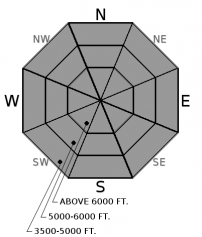
All weather stations reported temperatures above freezing overnight. This will be the first day without freezing at upper elevations overnight. In addition, the rain (.6 inch to 1 inch in 24 hours) has added weight and further weakened the snow surface at all elevations. Temperatures will reach into the 40s ºF by this afternoon, even at upper elevations. These unseasonably warm conditions combined with rain (up to and over 7000 feet elevation) will make wet loose avalanches a problem at all elevations and aspects today. The snowpack is becoming saturated at the upper layers and even deeper, allowing more snow available to be entrained and with the possibility of triggering a deeper instability. Avoid travelling on, or directly beneath slopes where you see signs of wet loose avalanches, such as rollerballs, pin-wheels, and sluffing in the surface snow.
-
Type ?
-
Aspect/Elevation ?
-
Likelihood ?CertainVery LikelyLikelyPossible
 Unlikely
 -
Size ?HistoricVery LargeLargeSmall

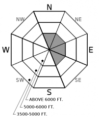
Little transport is likely to have happened yesterday, but previous slabs are still sensitive. For the most part these slabs can be found on easterly aspects due to the recent west-southwest winds. In some locations these wind slabs have been reactive, while in others they have not. However, above-freezing temperatures and rain will likely make any slab more unstable. Carefully evaluate any terrain where you find a cohesive slab and retreat to lower angled terrain if you see the tell-tale signs of instability such as shooting cracks or recent avalanche activity.
-
Type ?
-
Aspect/Elevation ?
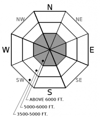
-
Likelihood ?CertainVery LikelyLikelyPossible
 Unlikely
 -
Size ?HistoricVery LargeLargeSmall

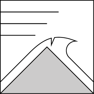
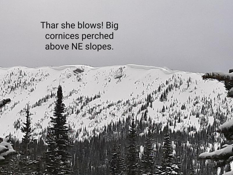
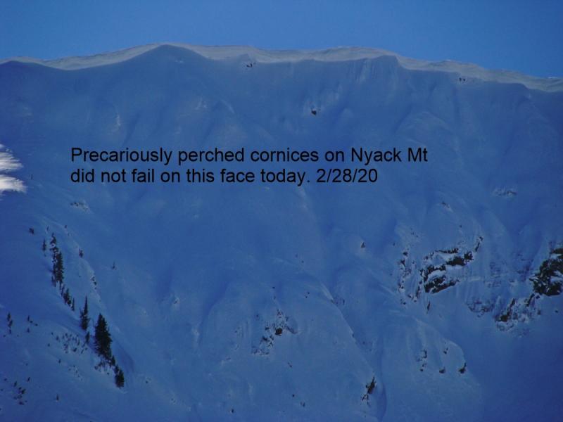
Winds and snowfall from the extended storm cycle earlier this month have formed large cornices across our advisory area. Recent warming temperatures and rain have weakened these features and it is best to give them a wide berth. BNSF Avalanche Safety observed cornice failures Monday and over the weekend in John F. Stevens Canyon in southern Glacier Park. Also keep in mind that falling cornices can trigger avalanches on the slopes beneath them. Avoid travelling on slopes underneath cornices.
Abundant snow over the last several weeks has formed a hefty slab on top of the February 10 rain crust that is now getting rain and settling. In isolated locations a layer of weak sugary snow (facets) sitting on top of this crust is fracturing and propagating across the column in stability tests. This was observed last week in southern Glacier Park and Monday in the Swan Range (Video). No avalanches have been reported or observed on this layer recently. BUT it is still important to do some hazard assessment and dig a snow pit and perform a stability test. This is the best way to tell how unstable this layer may be. In most locations the Feb. 10 crust is buried 2.5 to 4 feet from the snow surface. So, take a few extra minutes during your day and dig into the snow.
Spring can bring a mixed bag of weather conditions to northwest Montana. It can surprise us with intense snow squalls, warm temperatures, and rain-on-snow events (even in the same day). This makes it increasingly important to closely monitor changing conditions. With longer days and a higher sun angle, conditions can rapidly change.
Wednesday: BNSF avalanche safety reported two natural avalanches in the John F. Stevens Canyon very early in the morning that carried some debris to the valley floor. Due to darkness and poor visibility they were unable to see the start zones but believe the avalanches were approximately size D2 (could bury, injure or kill a person) and the debris was moist.
Tuesday: Seth, Todd and Jenny were in the Southern Whitefish Range near Ghoulie Point/Canyon Creek. Snow levels had reached over 6800 feet by the end of the day, rain was plentiful and the upper layers of the snowpack were becoming saturated. Rollerball and pinwheel activity was widespread and there was some cracking in the surface snow. Pits identified some weaknesses in the new snow, but no propagation occurred and no natural activity was observed. By afternoon, the warming and additional liquid precipitation was making it possible to trigger very small, wet loose avalanches on steep terrain.
Monday: Guy and Zachtern were in the Sixmile area in the Swan Range. In exposed terrain above 5500 feet they found widespread wind slabs. The snow/rain line was at about 5000 feet elevation when precipitation picked up in the early afternoon. In two different snow pits they had propagation with hard force in their extended column tests. One of these failures occurred on top of the Feb. 10 rain crust (Observation). BNSF Avalanche Safety toured in John F. Stevens Canyon in southern Glacier Park. West-southwest winds were actively loading easterly aspects above 6000 feet throughout the day. They also observed a recent cornice fall avalanche in the Shed 7 West path and small wet loose avalanches on steep slopes below 5500 feet. Skiers in John F. Stevens Canyon observed strong west winds that were loading easterly aspects above 6000 feet. They also noted the snow/rain line was at about 5000 feet and observed some small wet loose slides on southerly aspects below this elevation. Riders in the Stryker/Olney area in the Whitefish Range noted the warming conditions and found a wet, heavy snowpack and observed a few small wet loose avalanches.
Sunday: Mark toured in the Marion Lake area of the Flathead Range where the rain/snow line was at approximately 5400 feet Below 5400 feet the surface snow was saturated from recent heavy rain with up to 4" of new snow noted at upper elevations. Moderate winds transported snow at both mid and upper elevations throughout their tour. Cracking in the new dense snow and wind affected snow was frequent but propagation was limited. Skiers on Peak 6996 in southern Glacier Park reported snow, not rain, falling at the trailhead at 4500'. They also observed wind transporting the surface snow at upper elevations and new wind slab development. Near the summit they observed 8" of new snow and found the surface wind slab, and in sheltered areas the new snow, to be reactive but propagation was not observed.
See below for all observations this season.
Currently, temperatures above 6000 feet range from 33-39º F with light west to southwest winds at 3-7 mph with gusts 5-12 mph. Temperatures have remained above freezing overnight at all elevations. Today, we can expect mountain temperatures to warm into the low to mid-40s ºF with freezing levels reaching up to 7000 feet elevation or even higher. Yesterday our area received up to 1 inch of rain to over 7000 feet. Rain has continued through the night with more expected today, although tapering. The unseasonably warm weather with high elevation rain is predicted to last through tonight.
| 0600 temperature: | 33 to 39 deg. F. |
| Max. temperature in the last 24 hours: | 34 to 40 deg. F. |
| Average wind direction during the last 24 hours: | west-southwest |
| Average wind speed during the last 24 hours: | 2-21 mph |
| Maximum wind gust in the last 24 hours: | 2-35 mph |
| New snowfall in the last 24 hours: | 0-1 inches |
| Total snow depth: | 92-128 inches |
This advisory applies only to backcountry areas outside established ski area boundaries. This advisory describes general avalanche conditions and local variations always occur. This advisory expires at midnight on the posted day unless otherwise noted. The information in this advisory is provided by the USDA Forest Service who is solely responsible for its content.


