| Saturday | Saturday Night | Sunday | |
|---|---|---|---|
| Cloud Cover: | Dry conditions with light winds and seasonal temperatures. | Light snow/with windy conditions. | Snow tapers with windy conditions continuing. |
| Temperatures: | 34-43 deg. F. | 23-31 deg. F. | 32-41 deg. F. |
| Wind Direction: | Southwest | Southwest | West - southwest |
| Wind Speed: | 8-10 mph with gusts to 25 | 14-17 mph with gusts to 37 | 11-17 mph with gusts to 33 |
| Snowfall: | 0 in. | 3-5 in. | 0-2 in. |
| Snow Line: |
Whitefish Range
Swan Range
Flathead Range and Glacier National Park
How to read the forecast
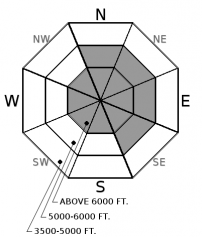
Yesterday, a widespread natural avalanche cycle occurred due to dense snow being deposited onto lower density snow combined with warming temperatures. Continued moderate to strong winds overnight have formed fresh wind slabs in favored windy locations. The avalanche danger is CONSIDERABLE above 5000 feet where a human triggered avalanche is likely. Carefully evaluate recent storm and wind deposited snow before committing to a slope. Below 5000 feet the danger is MODERATE where heightened avalanche conditions exist.

3. Considerable
?
Above 6500 ft.
3. Considerable
?
5000-6500 ft.
2. Moderate
?
3500-5000 ft.
- 1. Low
- 2. Moderate
- 3. Considerable
- 4. High
- 5. Extreme
-
Type ?
-
Aspect/Elevation ?

-
Likelihood ?CertainVery LikelyLikelyPossible
 Unlikely
 -
Size ?HistoricVery LargeLargeSmall

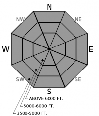
Yesterday, the arctic air mass retreated to the east allowing our typical southwest winds to return to all locations of our advisory area. Wind speeds throughout the day and overnight were impressive with sustained moderate winds and strong gusts recorded in favored locations. The Snowslip weather station in John F. Stevens Canyon recorded sustained winds of 21 mph and gusts to 43 while the Hornet weather station in the northern Whitefish Range recorded sustained winds up to 26 mph with gusts to 40. Today, expect to find fresh windslabs on typical leeward aspects but be alert for wind slabs formed by recent easterly winds on atypical slopes. Human triggered avalanches are likely on wind loaded terrain today.
Winds and snowfall from the bountiful 2 week storm cycle have formed large cornices across our advisory area. With warming temperatures today, it is best to give them a wide berth and avoid traveling underneath them.
-
Type ?
-
Aspect/Elevation ?

-
Likelihood ?CertainVery LikelyLikelyPossible
 Unlikely
 -
Size ?HistoricVery LargeLargeSmall

The heavy dense snow that fell Thursday night/Friday day was deposited onto lower density surface snow forming an "upside down" snow surface structure which resulted in a widespread natural avalanche cycle . FAC staff visited Noisy Basin in the Swan Range where they observed numerous thin (5-6") storm slab avalanches on all aspects at all elevations. BNSF avalanche safety noted a number of storm slabs that occurred during the day yesterday after the cold arctic air retreated to the east and was replaced by a warm air mass. The natural avalanche activity associated with this storm is mostly over but it remains likely that you could trigger a storm slab avalanche today.
-
Type ?
-
Aspect/Elevation ?

-
Likelihood ?CertainVery LikelyLikelyPossible
 Unlikely
 -
Size ?HistoricVery LargeLargeSmall

Precipitation Thursday night and Friday deposited rain at low and mid elevations along heavy dense snow at mid and upper elevations. Temperatures this morning are at or just below freezing at many locations with temperatures expected to rise above freezing at most locations today. Therefore, natural and human triggered wet loose avalanches are possible at all elevations as the day progresses. These slides will start out small but, with the copious amounts of unconsolidated snow at the snow surface, have the potential to entrain a fair amount of snow.
91 inches of snow accumulated across the advisory area in the past 13 days. Wind speeds ranged from calm to strong over this time as well. However, large cornices formed across the advisory area due to recent strong winds and abundant snow. These cornices loom over exposed leeward slopes in most areas. Minimize the time you spend on the slopes below these beasts and give them a wide margin of safety while traveling above them as they can release further behind the ridge line than expected.
All of this new snow also formed a hefty slab on top of the February 10 rain crust. In isolated locations (closer to the Continental Divide) a layer of weak sugary snow (facets) sitting on top of this crust fractured and propagated across the column in stability tests. Collapsing on this layer was also reported yesterday in southern GNP. No avalanches have been reported or observed on this layer recently, BUT it is important to assess this layer by digging into the snow. That is the only way you are going to know how a layer this deep is behaving. In most locations this layer existst 2.5 to 4 feet from the snow surface. So, do your homework, and dig into the snow.
If you have been in the mountains recently it doesn't look like Spring now, but it is rapidly approaching. Spring can bring a mixed bag of weather conditions to northwest Montana. It can surprise us with intense snow squalls, warm temperatures, and rain-on-snow events (even in the same day). This makes it increasingly important to closely monitor changing conditions. With longer days and higher sun angle conditions can rapidly change.
Friday: Guy and Mark traveled into Noisy Basin in the Swan Range where they observed numerous thin storm slab avalanches at all elevations and on all aspects. The dense 5-6" of new snow overnight had created an upside down snow surface structure and was responsible for these slides. They had failure at several locations in their pit due to density changes in the recent snow. In John F. Stevens Canyon, in southern Glacier Park, BNSF avalanche safety reported a number of storm slab avalanches as the arctic air retreated to the east and the day warmed.
Thursday: Skiers on Paola Ridge in the Flathead Range yesterday observed multiple recent avalanche crowns and witnessed one natural avalanche near the head of Dickey Creek. They suspected these were wind-slab related avalanches. They found deep stable snow conditions and noticed no propagation in their stability tests.
Wednesday: We rode into the Red Meadow area in the northern Whitefish Range on Wednesday. The moderate/strong winds created large plumes of snow blowing off of upper-elevation ridgelines. We also noted large cornice growth along leeward ridgelines. While skiing along the ridge we saw isolated cracking in the wind drifted snow. We dug a snow pit and did stability tests on a windloaded, north-facing slope and found a series of recent wind slabs. The most recent were 12-14 inches thick and still reactive. In several Extended Column Tests these slabs fractured and propagated with easy force (ECTP 3, 5). BNSF Avalanche Safety reported heavy wind loading on east aspects in the John F Stevens Canyon. Above 5000 feet they found widespread thin, reactive wind slabs. Another notable observation in this area was a reactive layer of facets above the Feb 10 crust that is now 80-90 cm from the surface (video).
See below for all observations this season.
Precipitation tapered through the day yesterday and exited our area late last night/early this morning. Temperatures overnight remained relatively warm and at or just below freezing above 6000 feet. Today, expect dry conditions with temperatures rising above freezing at most locations with light southwest winds and occasional moderate gusts. Precipitation returns to our area tonight accompanied by moderate to strong winds.
| 0600 temperature: | 26-33 deg. F. |
| Max. temperature in the last 24 hours: | 28-37 deg. F. |
| Average wind direction during the last 24 hours: | West - southwest |
| Average wind speed during the last 24 hours: | 5-26 mph |
| Maximum wind gust in the last 24 hours: | 24-43 mph |
| New snowfall in the last 24 hours: | 0-3 inches |
| Total snow depth: | 99-131 inches |
This advisory applies only to backcountry areas outside established ski area boundaries. This advisory describes general avalanche conditions and local variations always occur. This advisory expires at midnight on the posted day unless otherwise noted. The information in this advisory is provided by the USDA Forest Service who is solely responsible for its content.


