| Sunday | Sunday Night | Monday | |
|---|---|---|---|
| Cloud Cover: | Snow showers. | Decreasing temperatures and cooler air moving into our area. | Cooler with light snow. |
| Temperatures: | 24-35 deg. F. | 8-18 deg. F. | 21-30 deg. F. |
| Wind Direction: | South-southwest | Southwest | Southwest |
| Wind Speed: | 8-9 mph | 7-8 mph with gusts to 17 | 11-12 mph with gusts to 35 |
| Snowfall: | 3-5 in. | 0-1 in. | 2-5 in. |
| Snow Line: |
Whitefish Range
Swan Range
Flathead Range and Glacier National Park
How to read the forecast
New snow overnight and continued windy conditions have kept the avalanche danger elevated. Natural and human triggered avalanches have been observed for each of the past 3 days. Above 5000 feet the avalanche danger is CONSIDERABLE and human triggered avalanches are likely. Dangerous avalanche conditions exist with cautious route-finding and conservative decision making essential. Below 5000 feet the hazard is MODERATE due to the wet loose problem.

3. Considerable
?
Above 6500 ft.
3. Considerable
?
5000-6500 ft.
2. Moderate
?
3500-5000 ft.
- 1. Low
- 2. Moderate
- 3. Considerable
- 4. High
- 5. Extreme
-
Type ?
-
Aspect/Elevation ?

-
Likelihood ?CertainVery LikelyLikelyPossible
 Unlikely
 -
Size ?HistoricVery LargeLargeSmall

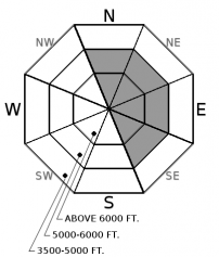
Last weeks abundant snowfall arrived with virtually no wind and therefore we enjoyed minimal wind slab problems. However, the winds have returned for the past 72 hours and have redistributed this low density snow and the recently fallen dense snow. Yesterday, the Hornet weather station in the northern Whitefish Range reported sustained winds of up to 34 mph with gusts up to 48. Snowslip weather station in southern Glacier Park reported peak gusts up to 43 mph. Expect to find thick slabs in favored windy locations across our area, especially in the alpine. In more protected areas expect to find thinner slabs. Regardless, these slabs need time to settle and strengthen. In exposed areas expect to find these slabs on cross-loaded mid slope features like spur ridges, tree islands, and rock out crops. Identify wind loaded terrain by looking for smooth, rounded features on the snow surface.
In many locations the wind and abundant snow formed large cornices. Because these are recently formed keep a safe distance back from these while traveling above and avoid traveling below them. Yesterday, skiers in the Apgar Range accidentally triggered a cornice failure. This shows the sensitivity that these wind features currently possess.
-
Type ?
-
Aspect/Elevation ?

-
Likelihood ?CertainVery LikelyLikelyPossible
 Unlikely
 -
Size ?HistoricVery LargeLargeSmall

Generally, storm slab problems are confined to the duration of the storm and perhaps a day or two following the end of the storm. Last weeks unusual storm created unusual conditions and therefore our storm slab problem has been prolonged. The storm deposited abundant low density snow which, combined with cold temperatures, left us without much of a storm slab problem. However, following the storm, we have seen a spike in temperatures along with a couple of warm storms that deposited thin layers of dense snow. This has created a bit of an "upside down" snowpack and a storm slab problem. A good example of this problem is the snowboarder triggered large storm slab avalanche Friday in the Skook Chutes of the southern Whitefish Range (observation). We continue to stress choosing conservative terrain to recreate in until the new snow has had an opportunity to settle out and gain strength. Pay attention to obvious signs of instability like recent avalanches, shooting cracks, and collapsing in the snow pack.
-
Type ?
-
Aspect/Elevation ?

-
Likelihood ?CertainVery LikelyLikelyPossible
 Unlikely
 -
Size ?HistoricVery LargeLargeSmall

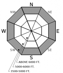
Following 2 days of above freezing temperatures at most low elevation locations the temperature dropped below freezing last evening. This has helped to strengthen the surface snow and minimize the wet loose hazard for today. However, I am keeping this problem for one more day because the refreezing of the snow surface was weak and the snow below this is moist from recent rain and warm temperatures. Loose wet avalanches can move fast and entrain a lot of snow. Avoid terrain traps like narrow gullies, trees, and cliffs that can amplify the effect of even a small loose wet avalanche.
Conditions can rapidly deteriorate during these warming trends so is important to pay attention to changing conditions. Additional heavy, wet snow, prolonged sun exposure, or rain-on snow will increase the danger. The abundant, low density snow that fell early in the week is becoming less stable as recent rising temperatures and increased winds contribute to slab formation.
Thanks to everyone who joined us yesterday for an afternoon of companion rescue at Bonsai Brewing Project. Thanks to Jesco Marine and Power Sports and Bonsai Brewing Project for the great raffle prizes.
Saturday: Riders in the Swan Range reported a rider triggered avalanche 4-5 feet deep and 300 yards wide. It appears to have occured on a north to northeast aspect at 6500'. Fortunately the 2 riders were able to ride out of the slide and were uninjured. Skiers in the Nyack area of the Flathead Range reported large slides in both Cascadilla and Wahoo Creeks. Skiers in the southern Apgar Range of Glacier Park reported large cornices and a skier triggered cornice failure.
Friday: A snowboarder triggered a 3-4' deep avalanche in the Skook Chutes, in the southern Whitefish Range, but fortunately was uninjured (observation). FAC staff were in the Apgar Range yesterday and experienced multiple collapses (whumpfs) and shooting cracks between 4000 and 5200 feet (summit of Apgar Mt.). Guy and Mark traveled into Cascade Creek, in the Flathead Range, where they found moist snow at low elevations that resulted in numerous rollerballs on their descent. At upper elevations they noted nearly 50" of settled snow on top of the February 16 rain crust. Active wind transport was observed and a recent slab avalanche was evident in Rescue Creek.
Thursday: A snowboarder triggered a storm slab avalanche in an area known as Chicken Bones in the southern Whitefish Range (observation). BNSF Avalanche Safety Team reported 3 natural wind slab avalanches that occurred in the John F Stevens Canyon. 2 were reported in the Shed 7 slide path, and 1 in the Infinity Path. All were estimated at 1 foot deep and propagated about 50 meters wide. Skiers on Paola Ridge in the Flathead Range experienced collapsing in the snowpack at low elevations (between 3500-5000 feet). They dug a pit and performed stability tests and found instability near the Feb. 10 rain crust. At 7000 feet they dug another pit and with hard force in an Extended Column Test found a layer that was 20 cm above the rain crust that fractured and propagated. This party also noted rain below 4000 feet on their egress. Skiers on Peak 6996 in southern Glacier National Park had consitent results in Extended Column Tests. A layer within last weeks storm snow fractured and propagated nearly 2 feet deep with moderate force (ECTP 16).
Wednesday: Skiers in the Flathead Range reported unstable storm and wind slabs. They noted cracking and remote triggering avalanches while traveling along a ridgeline. Winds were in excess of 50 mph and they found wind slabs that were 2.5 feet thick.
See below for all observations this season.
Yesterday was another mild day with partial clearing before precipitation moved back into our area last evening. Weather stations are reporting up to 6" of new snow overnight with the Swan and Flathead Ranges favored. Winds were out of the southwest at 1-34 mph with gusts from 12-48 mph. Currently, temperatures above 6000 feet range from 18-27ºF with winds out of the southwest at 3-8 mph with gusts of 7-12. Today should see temperatures reaching the mid to upper 20s with light southwest winds with an additonal few inches of new snow possible. Showers are expected to decrease later this afternoon and overnight.
| 0600 temperature: | 18-27 deg. F. |
| Max. temperature in the last 24 hours: | 26-36 deg. F. |
| Average wind direction during the last 24 hours: | West-southwest |
| Average wind speed during the last 24 hours: | 1-34 mph |
| Maximum wind gust in the last 24 hours: | 12-48 mph |
| New snowfall in the last 24 hours: | 1-6 inches |
| Total snow depth: | 98-125 inches |
This advisory applies only to backcountry areas outside established ski area boundaries. This advisory describes general avalanche conditions and local variations always occur. This advisory expires at midnight on the posted day unless otherwise noted. The information in this advisory is provided by the USDA Forest Service who is solely responsible for its content.


